
Mount Nabewari
鍋割山
Okutama, Tokyo / Ōme, Tokyo · Elevation 1,084 m
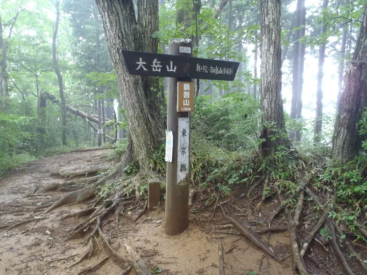
A 1,084 m peak on the boundary between Ōme City and Okutama Town in western Tokyo, set midway along the ridge linking Mount Mitake and Mount Ōdake. Its name comes from the silhouette of a pot split in half, and it is also known as Akuba-no-Kashira. Lying within Chichibu-Tama-Kai National Park, the wooded summit serves as a clearing on the popular Mitake-cable-Mitake-Okuno-in-Nabewari-Ōdake traverse and is featured each autumn on the official Mitake-yama Trail Run course.
Mount Nabewari at a glance
- Weather: The most settled day in the next 7 days is Wed, November 4: cloudy, gusts up to 4 m/s.
- Route: The shortest is Mount Mitake, Okunoin Peak and Mount Nabewari Circuit from Takimoto Station: about 4 h 10 min, 10.6 km, about 820 m of climbing.
Mount Nabewari weather (hourly, 14 days)
Sunrise today 06:07, sunset 16:47
| Tue, 11/3 | Wed, 11/4 | Thu, 11/5 | Fri, 11/6 | Sat, 11/7 | Sun, 11/8 | Mon, 11/9 | Tue, 11/10 | Wed, 11/11 | Thu, 11/12 | Fri, 11/13 | Sat, 11/14 | Sun, 11/15 | Mon, 11/16 | Tue, 11/17 | |||||||||||||||||||||||||||||||||||||||||||||||||||||||||||||||||||||||
|---|---|---|---|---|---|---|---|---|---|---|---|---|---|---|---|---|---|---|---|---|---|---|---|---|---|---|---|---|---|---|---|---|---|---|---|---|---|---|---|---|---|---|---|---|---|---|---|---|---|---|---|---|---|---|---|---|---|---|---|---|---|---|---|---|---|---|---|---|---|---|---|---|---|---|---|---|---|---|---|---|---|---|---|---|---|
| Japan time | 15 | 17 | 19 | 21 | 23 | 1 | 3 | 5 | 7 | 9 | 11 | 13 | 15 | 18 | 21 | 0 | 3 | 6 | 9 | 12 | 15 | 18 | 21 | 0 | 3 | 6 | 9 | 12 | 15 | 18 | 21 | 0 | 3 | 6 | 9 | 12 | 15 | 18 | 21 | 0 | 3 | 6 | 9 | 12 | 15 | 18 | 21 | 0 | 3 | 6 | 9 | 15 | 21 | 3 | 9 | 15 | 21 | 3 | 9 | 15 | 21 | 3 | 9 | 15 | 21 | 3 | 9 | 15 | 21 | 3 | 9 | 15 | 21 | 3 | 9 | 15 | 21 | 3 | 9 | 15 | 21 | 3 | 9 | 15 | |
  |   |   | | | | |   |   | | |   | | | | | | | |   | |   |   |  | | |  | | | | | | | | | | | | | | | | | | | | | | | | | | | | | | | | | |   |  | |   | | | | | | | | | | | | | | | |   | | | | | ||
| Temperature | °C | 11° | 10° | 9° | 8° | 8° | 7° | 7° | 7° | 7° | 7° | 8° | 8° | 7° | 7° | 7° | 7° | 7° | 8° | 11° | 16° | 12° | 10° | 9° | 8° | 7° | 7° | 14° | 17° | 15° | 11° | 8° | 7° | 6° | 5° | 10° | 11° | 9° | 5° | 3° | 3° | 2° | 1° | 8° | 10° | 9° | 7° | 6° | 5° | 4° | 4° | 5° | 7° | 5° | 3° | 5° | 6° | 3° | 1° | 8° | 9° | 0° | -2° | 6° | 6° | 5° | 1° | 9° | 10° | 0° | 0° | 4° | 6° | 1° | 1° | 7° | 9° | 8° | 7° | 13° | 16° | 6° | 5° | 3° | 5° |
| Precipitation | mm | 0.1 | 1.1 | 1.0 | 0.4 | 0.2 | 0.3 | 1.3 | 6 | 13 | 13 | 3.4 | 0.7 | 3.1 | 0.4 | 0.5 | 0.4 | 2.7 | 13 | 0.5 | |||||||||||||||||||||||||||||||||||||||||||||||||||||||||||||||||
| New snow | cm | ||||||||||||||||||||||||||||||||||||||||||||||||||||||||||||||||||||||||||||||||||||
| Snow depth | cm | 0 | 0 | 0 | 0 | 0 | 0 | 0 | 0 | 0 | 0 | 0 | 0 | 0 | 0 | 0 | 0 | 0 | 0 | 0 | 0 | 0 | 0 | 0 | 0 | 0 | 0 | 0 | 0 | 0 | 0 | 0 | 0 | 0 | 0 | 0 | 0 | 0 | 0 | 0 | 0 | 0 | 0 | 0 | 0 | 0 | 0 | 0 | 0 | 0 | 0 | 0 | 0 | 0 | 0 | 0 | 0 | 0 | 0 | 0 | 0 | 0 | 0 | 0 | 0 | 0 | 0 | 0 | 0 | 0 | 0 | 0 | 0 | 0 | 0 | 0 | 0 | 0 | 0 | 0 | 0 | 0 | 0 | 0 | 0 |
| Wind | m/s | 2 | 0 | 0 | 0 | 0 | 0 | 0 | 0 | 1 | 1 | 1 | 1 | 0 | 1 | 1 | 1 | 3 | 2 | 2 | 2 | 2 | 1 | 0 | 0 | 1 | 1 | 0 | 3 | 2 | 1 | 1 | 1 | 0 | 0 | 2 | 3 | 3 | 1 | 1 | 1 | 1 | 1 | 1 | 3 | 2 | 0 | 1 | 0 | 1 | 1 | 1 | 2 | 1 | 2 | 1 | 2 | 1 | 2 | 5 | 4 | 2 | 1 | 1 | 2 | 1 | 1 | 0 | 4 | 1 | 0 | 1 | 2 | 1 | 0 | 1 | 1 | 0 | 1 | 0 | 4 | 2 | 1 | 1 | 2 |
| Wind gusts | m/s | 5 | 5 | 1 | 1 | 1 | 2 | 2 | 1 | 3 | 4 | 4 | 4 | 4 | 2 | 3 | 4 | 6 | 6 | 7 | 7 | 6 | 5 | 2 | 2 | 2 | 3 | 3 | 8 | 8 | 5 | 4 | 4 | 3 | 2 | 5 | 8 | 9 | 7 | 3 | 3 | 3 | 4 | 4 | 9 | 9 | 5 | 2 | 3 | 2 | 2 | 4 | 7 | 5 | 4 | 5 | 7 | 6 | 4 | 13 | 18 | 10 | 6 | 5 | 9 | 5 | 3 | 5 | 11 | 9 | 3 | 5 | 7 | 6 | 2 | 4 | 7 | 4 | 4 | 4 | 11 | 15 | 5 | 4 | 7 |
| Wind dir. | ↓ | ↓ | ↓ | ↓ | ↓ | ↓ | ↓ | ↓ | ↓ | ↓ | ↓ | ↓ | ↓ | ↓ | ↓ | ↓ | ↓ | ↓ | ↓ | ↓ | ↓ | ↓ | ↓ | ↓ | ↓ | ↓ | ↓ | ↓ | ↓ | ↓ | ↓ | ↓ | ↓ | ↓ | ↓ | ↓ | ↓ | ↓ | ↓ | ↓ | ↓ | ↓ | ↓ | ↓ | ↓ | ↓ | ↓ | ↓ | ↓ | ↓ | ↓ | ↓ | ↓ | ↓ | ↓ | ↓ | ↓ | ↓ | ↓ | ↓ | ↓ | ↓ | ↓ | ↓ | ↓ | ↓ | ↓ | ↓ | ↓ | ↓ | ↓ | ↓ | ↓ | ↓ | ↓ | ↓ | ↓ | ↓ | ↓ | ↓ | ↓ | ↓ | ↓ | ↓ | |
Mount Nabewari hiking routes
- Mount Mitake, Okunoin Peak and Mount Nabewari Circuit from Takimoto Station 10.6 km · Ascent 816 m Takimoto (Station), 滝本駅 (Aerialway station), ケーブル下バス停 (Bus stop), ケーブル下 (Bus stop), Times
- Mount Odake, Mount Nabewari and Okunoin Peak Loop from Mount Mitake 10.4 km · Ascent 935 m Mount Mitake (Station), 御岳平駅 (Aerialway station), 大展望台駅 (Aerialway station)
- Okutama–Mitake Traverse via Nokogiriyama and Odakesan 12.2 km · Ascent 1,464 m Okutama Station (Bus stop), Oku-Tama (Station), 南一丁目 (Bus stop), 下栃久保 (Bus stop), Times → Mount Mitake (Station), 御岳平駅 (Aerialway station), 大展望台駅 (Aerialway station)
Hiking times are estimates calculated from the terrain.
Huts, campsites and lodging near Mount Nabewari
Mountain huts
- Shinonome-sanso
Campsites
- 大岳鍾乳洞 大岳キャンプ場
- アメリカキャンプ村
- 鳩ノ巣バンガロー
- 奥多摩福音の家
- Kawai Campsite
Lodging
- Komadori Sanso
- Machiya
- Sankoso
- Kuraya
- Ryoso Utsuboya
Mount Nabewari facts
- Also known as
- 芥場ノ頭
- Elevation
- 1,084 m
- Location
- Okutama, Tokyo / Ōme, Tokyo
35.778093, 139.137109 - National Park
- 秩父多摩甲斐国立公園
- Website
- www.kankyo1.metro.tokyo.lg.jp
- Access Information
- www.kankyo1.metro.tokyo.lg.jp
- Wikipedia
- ja.wikipedia.org