
Mt. Abearakuradake
安倍荒倉岳
Ina, Nagano · Elevation 2,693 m
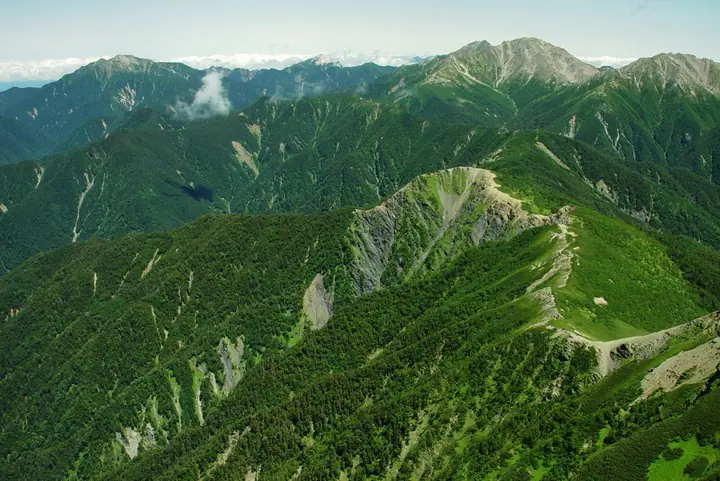
Abearakuradake is a 2,693 m peak straddling Ina City (Nagano) and Aoi Ward of Shizuoka City, sitting on the Senshio Ridge of the Akaishi Mountains (Southern Japanese Alps) that connects Mt. Senjō and Mt. Shiomi. It lies within Minami Alps National Park and is selected as one of Japan's 100 Highest Peaks (日本百高山). The summit is a quiet, conifer-clad point on the long ridge traverse linking Shiomi to Senjō.
Mt. Abearakuradake at a glance
- Weather: The most settled day in the next 7 days is Sun, November 8: clear, gusts up to 10 m/s. Sat, Nov 7: strong wind (gusts up to 16 m/s).
Mt. Abearakuradake weather (hourly, 14 days)
Sunrise today 06:10, sunset 16:51
| Tue, 11/3 | Wed, 11/4 | Thu, 11/5 | Fri, 11/6 | Sat, 11/7 | Sun, 11/8 | Mon, 11/9 | Tue, 11/10 | Wed, 11/11 | Thu, 11/12 | Fri, 11/13 | Sat, 11/14 | Sun, 11/15 | Mon, 11/16 | Tue, 11/17 | |||||||||||||||||||||||||||||||||||||||||||||||||||||||||||||||||||||||
|---|---|---|---|---|---|---|---|---|---|---|---|---|---|---|---|---|---|---|---|---|---|---|---|---|---|---|---|---|---|---|---|---|---|---|---|---|---|---|---|---|---|---|---|---|---|---|---|---|---|---|---|---|---|---|---|---|---|---|---|---|---|---|---|---|---|---|---|---|---|---|---|---|---|---|---|---|---|---|---|---|---|---|---|---|---|
| Japan time | 15 | 17 | 19 | 21 | 23 | 1 | 3 | 5 | 7 | 9 | 11 | 13 | 15 | 18 | 21 | 0 | 3 | 6 | 9 | 12 | 15 | 18 | 21 | 0 | 3 | 6 | 9 | 12 | 15 | 18 | 21 | 0 | 3 | 6 | 9 | 12 | 15 | 18 | 21 | 0 | 3 | 6 | 9 | 12 | 15 | 18 | 21 | 0 | 3 | 6 | 9 | 15 | 21 | 3 | 9 | 15 | 21 | 3 | 9 | 15 | 21 | 3 | 9 | 15 | 21 | 3 | 9 | 15 | 21 | 3 | 9 | 15 | 21 | 3 | 9 | 15 | 21 | 3 | 9 | 15 | 21 | 3 | 9 | 15 | |
 |   | |   | | | | |   |   | |   |   |   | | | | | | |   |   | | |   |   | | | |  | | | | | | | | | | | | | | | | | |   | | | | | |   | | | | | | |   |  | | | | | | | | | | | | | | | | |   | | | | | | ||
| Temperature | °C | 4° | -2° | -4° | -5° | -6° | -5° | -4° | -3° | -1° | 3° | 5° | 6° | 3° | 1° | 1° | 1° | 2° | 3° | 6° | 9° | 5° | 3° | 1° | 1° | 2° | 2° | 5° | 9° | 7° | 0° | -2° | -4° | -6° | -8° | -2° | 2° | 1° | -6° | -7° | -6° | -5° | -5° | 3° | 4° | 2° | -4° | -3° | -3° | -3° | -3° | 0° | 2° | -5° | -8° | -1° | -1° | -4° | -7° | -4° | -1° | -6° | -5° | 0° | 0° | -5° | -5° | 0° | 1° | -5° | -4° | 2° | 2° | -5° | -4° | 3° | 3° | 2° | 1° | 5° | 6° | -3° | -3° | 1° | 1° |
| Precipitation | mm | 0.3 | 0.9 | 0.3 | 6 | 11 | 6 | 0.1 | 1.3 | 0.1 | 0.7 | 0.1 | 0.1 | 10 | 16 | 0.3 | |||||||||||||||||||||||||||||||||||||||||||||||||||||||||||||||||||||
| New snow | cm | <.1 | <.1 | <.1 | <.1 | ||||||||||||||||||||||||||||||||||||||||||||||||||||||||||||||||||||||||||||||||
| Snow depth | cm | 0 | 0 | 0 | 0 | 0 | 0 | 0 | 0 | 0 | 0 | 0 | 0 | 0 | 0 | 0 | 0 | 0 | 0 | 0 | 0 | 0 | 0 | 0 | 0 | 0 | 0 | 0 | 0 | 0 | 0 | 0 | 0 | 0 | 0 | 0 | 0 | 0 | 0 | 0 | 0 | 0 | 0 | 0 | 0 | 0 | 0 | 0 | 0 | 0 | 0 | 0 | 0 | 0 | 0 | 0 | 0 | 0 | 0 | 0 | 0 | 0 | 0 | 0 | 0 | 0 | 0 | 0 | 0 | 0 | 0 | 0 | 0 | 0 | 0 | 0 | 0 | 0 | 0 | 0 | 0 | 0 | 0 | 0 | 0 |
| Wind | m/s | 1 | 0 | 1 | 1 | 1 | 1 | 1 | 1 | 1 | 1 | 1 | 1 | 1 | 2 | 2 | 2 | 2 | 1 | 0 | 1 | 2 | 1 | 1 | 1 | 2 | 1 | 2 | 2 | 2 | 2 | 2 | 2 | 3 | 2 | 3 | 2 | 2 | 1 | 1 | 1 | 1 | 1 | 1 | 1 | 1 | 0 | 1 | 2 | 1 | 1 | 2 | 1 | 0 | 1 | 1 | 2 | 2 | 3 | 3 | 1 | 0 | 1 | 2 | 2 | 0 | 1 | 1 | 0 | 1 | 1 | 1 | 1 | 1 | 1 | 2 | 2 | 2 | 2 | 2 | 2 | 1 | 1 | 1 | 1 |
| Wind gusts | m/s | 9 | 8 | 7 | 8 | 8 | 9 | 8 | 8 | 8 | 8 | 9 | 8 | 8 | 10 | 11 | 13 | 15 | 14 | 9 | 9 | 14 | 13 | 11 | 12 | 14 | 14 | 12 | 13 | 13 | 12 | 14 | 15 | 16 | 16 | 16 | 16 | 14 | 13 | 11 | 11 | 11 | 10 | 9 | 10 | 10 | 8 | 11 | 12 | 12 | 12 | 12 | 13 | 8 | 9 | 11 | 13 | 12 | 18 | 19 | 18 | 9 | 8 | 10 | 11 | 10 | 7 | 10 | 10 | 7 | 6 | 6 | 8 | 8 | 10 | 11 | 14 | 17 | 17 | 15 | 12 | 11 | 7 | 7 | 8 |
| Wind dir. | ↓ | ↓ | ↓ | ↓ | ↓ | ↓ | ↓ | ↓ | ↓ | ↓ | ↓ | ↓ | ↓ | ↓ | ↓ | ↓ | ↓ | ↓ | ↓ | ↓ | ↓ | ↓ | ↓ | ↓ | ↓ | ↓ | ↓ | ↓ | ↓ | ↓ | ↓ | ↓ | ↓ | ↓ | ↓ | ↓ | ↓ | ↓ | ↓ | ↓ | ↓ | ↓ | ↓ | ↓ | ↓ | ↓ | ↓ | ↓ | ↓ | ↓ | ↓ | ↓ | ↓ | ↓ | ↓ | ↓ | ↓ | ↓ | ↓ | ↓ | ↓ | ↓ | ↓ | ↓ | ↓ | ↓ | ↓ | ↓ | ↓ | ↓ | ↓ | ↓ | ↓ | ↓ | ↓ | ↓ | ↓ | ↓ | ↓ | ↓ | ↓ | ↓ | ↓ | ↓ | |
Huts, campsites and lodging near Mt. Abearakuradake
Mountain huts
- Kumanodaira Hut 2026: open July 11–September 22 · reservation required · sleeps 30
- Notori Hut reservation required
Campsites
- Notori Campground
Lists that include Mt. Abearakuradake
Japan's 100 Highest Mountains · Elevations of 1003 Mountains of Japan
Mt. Abearakuradake facts
- Elevation
- 2,693 m
- Location
- Ina, Nagano
35.623056, 138.202971 - National Park
- 南アルプス国立公園
- Wikipedia
- ja.wikipedia.org