
Mount Ōmi-Kurohime
黒姫山
Itoigawa, Niigata · Elevation 1,221 m
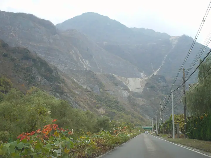
Mount Ōmi-Kurohime is a 1,221-metre peak in Itoigawa City, Niigata Prefecture, sitting at the northern end of the Hida Mountains. Composed almost entirely of limestone, the mountain is the site of one of Japan's largest limestone quarries. It is one of the 'Three Kurohime' alongside the Shinano and Jōshū peaks of the same name, and is listed among Japan's 300 Famous Mountains and the Echigo Hundred. The mountain is also a geosite of the Itoigawa UNESCO Global Geopark.
Mount Ōmi-Kurohime at a glance
- Weather: The most settled day in the next 7 days is Wed, November 4: clear, gusts up to 10 m/s. Fri, Nov 6: strong wind (gusts up to 21 m/s).
- Route: The shortest is Mount Kurohime in Itoigawa, a Limestone Peak, Return via Ipponsugi Pass and Kanakidaira: about 5 h 49 min, 7.9 km, about 1,130 m of climbing.
Mount Ōmi-Kurohime weather (hourly, 14 days)
Sunrise today 06:14, sunset 16:51
| Tue, 11/3 | Wed, 11/4 | Thu, 11/5 | Fri, 11/6 | Sat, 11/7 | Sun, 11/8 | Mon, 11/9 | Tue, 11/10 | Wed, 11/11 | Thu, 11/12 | Fri, 11/13 | Sat, 11/14 | Sun, 11/15 | Mon, 11/16 | Tue, 11/17 | |||||||||||||||||||||||||||||||||||||||||||||||||||||||||||||||||||||||
|---|---|---|---|---|---|---|---|---|---|---|---|---|---|---|---|---|---|---|---|---|---|---|---|---|---|---|---|---|---|---|---|---|---|---|---|---|---|---|---|---|---|---|---|---|---|---|---|---|---|---|---|---|---|---|---|---|---|---|---|---|---|---|---|---|---|---|---|---|---|---|---|---|---|---|---|---|---|---|---|---|---|---|---|---|---|
| Japan time | 15 | 17 | 19 | 21 | 23 | 1 | 3 | 5 | 7 | 9 | 11 | 13 | 15 | 18 | 21 | 0 | 3 | 6 | 9 | 12 | 15 | 18 | 21 | 0 | 3 | 6 | 9 | 12 | 15 | 18 | 21 | 0 | 3 | 6 | 9 | 12 | 15 | 18 | 21 | 0 | 3 | 6 | 9 | 12 | 15 | 18 | 21 | 0 | 3 | 6 | 9 | 15 | 21 | 3 | 9 | 15 | 21 | 3 | 9 | 15 | 21 | 3 | 9 | 15 | 21 | 3 | 9 | 15 | 21 | 3 | 9 | 15 | 21 | 3 | 9 | 15 | 21 | 3 | 9 | 15 | 21 | 3 | 9 | 15 | |
  |   | |   | | | |  |  | | | | | | |   |   | |   |   |   | |   | | | | |   | | | | | | | | | | | | | | | |   | | | | | | | | | | | | | |   |   | | | | | | | | | | | | | |  | | | | |   | | | | | | | ||
| Temperature | °C | 8° | 5° | 3° | 1° | 1° | 1° | 0° | 1° | 3° | 9° | 11° | 11° | 10° | 7° | 9° | 8° | 8° | 8° | 9° | 13° | 13° | 10° | 10° | 9° | 9° | 9° | 11° | 13° | 9° | 7° | 5° | 4° | 2° | 2° | 2° | 2° | 2° | 1° | 0° | 0° | -1° | -1° | 4° | 6° | 5° | 3° | 3° | 2° | 2° | 2° | 5° | 4° | 2° | -1° | 7° | 9° | 5° | 0° | 2° | 3° | 1° | 0° | 5° | 6° | 0° | 3° | 3° | 4° | 1° | -3° | 6° | 7° | 0° | 0° | 10° | 10° | 7° | 8° | 9° | 5° | 2° | 1° | 3° | 4° |
| Precipitation | mm | 7 | 7 | 3.8 | 2.1 | 1.4 | 0.1 | 1.9 | 3.8 | 0.7 | 1.0 | 1.1 | 1.9 | 1.6 | 2.5 | 2.4 | 2.8 | 5.0 | 4.0 | 4.4 | 2.3 | 1.2 | 0.8 | 0.4 | 0.3 | 0.2 | 1.2 | 1.2 | 1.4 | 0.8 | 3.6 | 13 | 9 | 7 | 6 | 1.0 | 2.2 | 17 | 6 | 0.3 | 0.3 | 8 | 2.3 | 18 | 27 | 12 | 1.6 | ||||||||||||||||||||||||||||||||||||||
| New snow | cm | 1.1 | 0.8 | ||||||||||||||||||||||||||||||||||||||||||||||||||||||||||||||||||||||||||||||||||
| Snow depth | cm | 0 | 0 | 0 | 0 | 0 | 0 | 0 | 0 | 0 | 0 | 0 | 0 | 0 | 0 | 0 | 0 | 0 | 0 | 0 | 0 | 0 | 0 | 0 | 0 | 0 | 0 | 0 | 0 | 0 | 0 | 0 | 0 | 0 | 0 | 0 | 0 | 0 | 0 | 0 | 0 | 0 | 0 | 0 | 0 | 0 | 0 | 0 | 0 | 0 | 0 | 0 | 0 | 0 | 0 | 0 | 0 | 0 | <1 | <1 | 0 | 0 | 0 | 0 | 0 | 0 | 0 | 0 | 0 | 0 | 0 | 0 | 0 | 0 | 0 | 0 | 0 | 0 | 0 | 0 | 0 | 0 | 0 | 0 | 0 |
| Wind | m/s | 2 | 1 | 1 | 1 | 2 | 2 | 2 | 2 | 2 | 3 | 4 | 4 | 3 | 1 | 3 | 3 | 2 | 1 | 1 | 1 | 1 | 1 | 1 | 1 | 2 | 4 | 5 | 8 | 6 | 6 | 6 | 5 | 6 | 5 | 5 | 5 | 5 | 4 | 3 | 3 | 3 | 3 | 1 | 3 | 1 | 2 | 1 | 1 | 2 | 1 | 1 | 3 | 2 | 1 | 2 | 2 | 5 | 9 | 4 | 2 | 2 | 2 | 1 | 4 | 2 | 3 | 3 | 2 | 2 | 2 | 1 | 1 | 1 | 1 | 1 | 1 | 3 | 2 | 3 | 5 | 3 | 2 | 2 | 2 |
| Wind gusts | m/s | 7 | 6 | 3 | 4 | 5 | 5 | 5 | 5 | 5 | 8 | 10 | 10 | 10 | 8 | 7 | 7 | 6 | 6 | 5 | 5 | 5 | 5 | 5 | 4 | 6 | 11 | 16 | 19 | 21 | 18 | 17 | 16 | 16 | 17 | 14 | 15 | 14 | 13 | 10 | 9 | 9 | 8 | 7 | 8 | 8 | 5 | 5 | 4 | 4 | 5 | 5 | 7 | 8 | 5 | 5 | 8 | 17 | 25 | 24 | 14 | 7 | 5 | 6 | 11 | 10 | 12 | 9 | 7 | 6 | 6 | 6 | 6 | 5 | 6 | 6 | 5 | 9 | 10 | 12 | 14 | 13 | 7 | 6 | 8 |
| Wind dir. | ↓ | ↓ | ↓ | ↓ | ↓ | ↓ | ↓ | ↓ | ↓ | ↓ | ↓ | ↓ | ↓ | ↓ | ↓ | ↓ | ↓ | ↓ | ↓ | ↓ | ↓ | ↓ | ↓ | ↓ | ↓ | ↓ | ↓ | ↓ | ↓ | ↓ | ↓ | ↓ | ↓ | ↓ | ↓ | ↓ | ↓ | ↓ | ↓ | ↓ | ↓ | ↓ | ↓ | ↓ | ↓ | ↓ | ↓ | ↓ | ↓ | ↓ | ↓ | ↓ | ↓ | ↓ | ↓ | ↓ | ↓ | ↓ | ↓ | ↓ | ↓ | ↓ | ↓ | ↓ | ↓ | ↓ | ↓ | ↓ | ↓ | ↓ | ↓ | ↓ | ↓ | ↓ | ↓ | ↓ | ↓ | ↓ | ↓ | ↓ | ↓ | ↓ | ↓ | ↓ | |
Mount Ōmi-Kurohime hiking routes
Hiking times are estimates calculated from the terrain.
Huts, campsites and lodging near Mount Ōmi-Kurohime
Lodging
- 山岸荘
Lists that include Mount Ōmi-Kurohime
Japan's 300 Famous Mountains · Niigata 100 Famous Mountains · Elevations of 1003 Mountains of Japan · 1000 Mountains of Japan
Mount Ōmi-Kurohime facts
- Elevation
- 1,221 m
- Location
- Itoigawa, Niigata
36.976617, 137.790071 - Website
- www.itoigawa-kanko.net
- Trail Map
- www.itoigawa-kanko.net (PDF)
- Wikipedia
- ja.wikipedia.org