
Mount Iwaguro
岩黒山
Saijo, Ehime / Kumakogen, Ehime / Ino, Kochi · Elevation 1,746 m
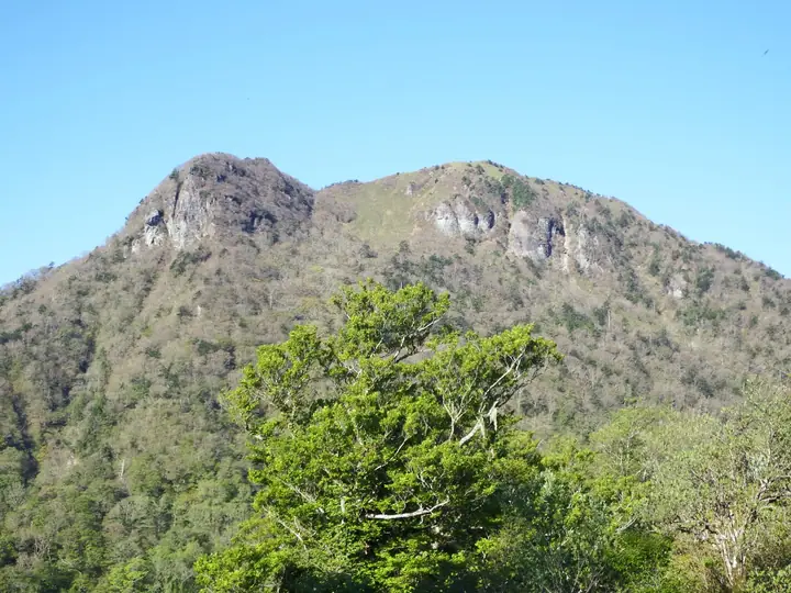
Mount Iwaguro is a 1,746-meter peak in Kumakōgen Town (Kamiukena District), Ehime Prefecture, set on the Ishizuchi Range to the south of Mt. Ishizuchi proper, on the ridge that runs from Tsuchi-goya pass toward Mt. Tsutsujōsan (1,859 m) and Mt. Tebako. The summit looks north to Ishizuchi and south to Tsutsujōsan, and is known for its early-summer azaleas; the peak is included in the Shikoku Hyakumeizan and Shikoku Hyakuzan lists.
Mount Iwaguro at a glance
- Weather: The most settled day in the next 7 days is Sun, November 8: clear, gusts up to 6 m/s. Fri, Nov 6: strong wind (gusts up to 17 m/s).
- Route: The shortest is Ishizuchi Range Loop from Tsuchigoya over Iwaguro, Tebako and Tsutsujo, Three Peaks Facing Ishizuchi: about 6 h 44 min, 11.1 km, about 870 m of climbing.
Mount Iwaguro weather (hourly, 14 days)
Sunrise today 06:28, sunset 17:14
| Tue, 11/3 | Wed, 11/4 | Thu, 11/5 | Fri, 11/6 | Sat, 11/7 | Sun, 11/8 | Mon, 11/9 | Tue, 11/10 | Wed, 11/11 | Thu, 11/12 | Fri, 11/13 | Sat, 11/14 | Sun, 11/15 | Mon, 11/16 | Tue, 11/17 | |||||||||||||||||||||||||||||||||||||||||||||||||||||||||||||||||||||||
|---|---|---|---|---|---|---|---|---|---|---|---|---|---|---|---|---|---|---|---|---|---|---|---|---|---|---|---|---|---|---|---|---|---|---|---|---|---|---|---|---|---|---|---|---|---|---|---|---|---|---|---|---|---|---|---|---|---|---|---|---|---|---|---|---|---|---|---|---|---|---|---|---|---|---|---|---|---|---|---|---|---|---|---|---|---|
| Japan time | 21 | 23 | 1 | 3 | 5 | 7 | 9 | 11 | 13 | 15 | 17 | 19 | 21 | 0 | 3 | 6 | 9 | 12 | 15 | 18 | 21 | 0 | 3 | 6 | 9 | 12 | 15 | 18 | 21 | 0 | 3 | 6 | 9 | 12 | 15 | 18 | 21 | 0 | 3 | 6 | 9 | 12 | 15 | 18 | 21 | 0 | 3 | 6 | 9 | 12 | 15 | 21 | 3 | 9 | 15 | 21 | 3 | 9 | 15 | 21 | 3 | 9 | 15 | 21 | 3 | 9 | 15 | 21 | 3 | 9 | 15 | 21 | 3 | 9 | 15 | 21 | 3 | 9 | 15 | 21 | 3 | 9 | 15 | 21 | |
 |   |   | |   |   | | | | | | | |   |   | | |   | | | | | | | | |  |  | | | | |   | | | | | | | | | | | | | | | | | |   | | | | |   | |   | | | | | | | | | |  | | | | | | | | | | |   | | | | |  | ||
| Temperature | °C | 3° | 3° | 4° | 4° | 4° | 4° | 7° | 8° | 9° | 9° | 7° | 7° | 7° | 8° | 8° | 9° | 11° | 12° | 12° | 11° | 10° | 10° | 7° | 6° | 6° | 10° | 8° | 4° | 1° | 1° | 0° | 0° | 2° | 5° | 4° | 0° | -2° | -2° | -2° | -1° | 5° | 8° | 7° | 3° | 4° | 4° | 4° | 3° | 6° | 6° | 5° | 2° | -1° | 4° | 6° | 0° | -1° | 0° | 4° | -1° | -1° | 4° | 6° | 1° | -1° | 4° | 6° | 0° | -1° | 7° | 10° | 3° | 4° | 7° | 9° | 8° | 9° | 8° | 9° | 4° | 0° | 3° | 7° | 0° |
| Precipitation | mm | 0.3 | 1.8 | 0.6 | 1.8 | 2.0 | 2.6 | 1.5 | 1.8 | 0.6 | 0.1 | 0.5 | 0.8 | 0.6 | 0.3 | 0.1 | 0.3 | 2.1 | 5 | 0.7 | 0.6 | 1.4 | 1.3 | 0.1 | |||||||||||||||||||||||||||||||||||||||||||||||||||||||||||||
| New snow | cm | – | – | – | |||||||||||||||||||||||||||||||||||||||||||||||||||||||||||||||||||||||||||||||||
| Snow depth | cm | 0 | 0 | 0 | 0 | 0 | 0 | 0 | 0 | 0 | 0 | 0 | 0 | 0 | 0 | 0 | 0 | 0 | 0 | 0 | 0 | 0 | 0 | 0 | 0 | 0 | 0 | 0 | 0 | 0 | 0 | 0 | 0 | 0 | 0 | 0 | 0 | 0 | 0 | 0 | 0 | 0 | 0 | 0 | 0 | 0 | 0 | 0 | 0 | 0 | 0 | 0 | 0 | 0 | 0 | 0 | 0 | 0 | 0 | 0 | 0 | 0 | 0 | 0 | 0 | 0 | 0 | 0 | 0 | 0 | 0 | 0 | 0 | 0 | 0 | 0 | 0 | 0 | 0 | 0 | 0 | 0 | 0 | 0 | 0 |
| Wind | m/s | 1 | 1 | 1 | 1 | 1 | 1 | 1 | 1 | 1 | 1 | 1 | 1 | 1 | 0 | 1 | 0 | 1 | 2 | 3 | 2 | 2 | 4 | 4 | 5 | 4 | 6 | 5 | 4 | 4 | 4 | 4 | 4 | 5 | 4 | 4 | 2 | 2 | 2 | 2 | 2 | 1 | 1 | 1 | 1 | 1 | 1 | 1 | 2 | 3 | 3 | 2 | 1 | 1 | 2 | 4 | 4 | 6 | 4 | 3 | 1 | 1 | 1 | 3 | 1 | 2 | 3 | 3 | 2 | 1 | 1 | 1 | 1 | 2 | 3 | 4 | 2 | 3 | 4 | 5 | 3 | 2 | 2 | 2 | 1 |
| Wind gusts | m/s | 4 | 3 | 4 | 4 | 5 | 5 | 5 | 6 | 5 | 5 | 4 | 4 | 4 | 4 | 5 | 4 | 5 | 9 | 11 | 10 | 10 | 15 | 15 | 16 | 16 | 17 | 17 | 15 | 14 | 12 | 13 | 13 | 14 | 14 | 13 | 12 | 9 | 7 | 7 | 6 | 6 | 6 | 6 | 4 | 3 | 5 | 6 | 7 | 9 | 10 | 9 | 9 | 5 | 8 | 13 | 13 | 16 | 16 | 13 | 10 | 5 | 5 | 8 | 8 | 9 | 10 | 10 | 8 | 6 | 5 | 6 | 6 | 7 | 11 | 14 | 14 | 12 | 12 | 14 | 13 | 9 | 6 | 7 | 6 |
| Wind dir. | ↓ | ↓ | ↓ | ↓ | ↓ | ↓ | ↓ | ↓ | ↓ | ↓ | ↓ | ↓ | ↓ | ↓ | ↓ | ↓ | ↓ | ↓ | ↓ | ↓ | ↓ | ↓ | ↓ | ↓ | ↓ | ↓ | ↓ | ↓ | ↓ | ↓ | ↓ | ↓ | ↓ | ↓ | ↓ | ↓ | ↓ | ↓ | ↓ | ↓ | ↓ | ↓ | ↓ | ↓ | ↓ | ↓ | ↓ | ↓ | ↓ | ↓ | ↓ | ↓ | ↓ | ↓ | ↓ | ↓ | ↓ | ↓ | ↓ | ↓ | ↓ | ↓ | ↓ | ↓ | ↓ | ↓ | ↓ | ↓ | ↓ | ↓ | ↓ | ↓ | ↓ | ↓ | ↓ | ↓ | ↓ | ↓ | ↓ | ↓ | ↓ | ↓ | ↓ | ↓ | |
Mount Iwaguro hiking routes
Hiking times are estimates calculated from the terrain.
Huts, campsites and lodging near Mount Iwaguro
Mountain huts
- 丸滝小屋 unstaffed
- 白石ロッジ temporarily closed
- 山荘しらさ 2026: open April 5–November 25 · reservation required · sleeps 21
- シラサ小屋 unstaffed
- 石鎚山公衆トイレ休憩所 unstaffed
Campsites
- 白猪谷オートキャンプ場
Lodging
- 国民宿舎石鎚
Lists that include Mount Iwaguro
Mount Iwaguro facts
- Elevation
- 1,746 m
- Location
- Saijo, Ehime / Kumakogen, Ehime / Ino, Kochi
33.750758, 133.156984 - Website
- ishizuchisankei.com (PDF)
- Access Information
- ishizuchisankei.com