
Mount Dōgamori
堂ヶ森
Kumakogen, Ehime · Elevation 1,689 m
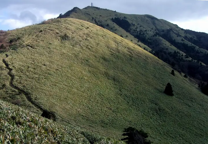
Mount Dōgamori is a 1,689 m peak straddling Saijō and Kumakōgen in Ehime Prefecture, forming the western terminus of the Ishizuchi range within Ishizuchi Quasi-National Park. Above roughly 1,400 m the slopes open into sweeping Omogo bamboo grasslands, and a large microwave reflector on the summit makes it easy to identify from afar. The top commands a broad panorama of Matsuyama, the Seto Inland Sea, and the chain of Mount Ninomori and Mount Ishizuchi to the east, and is included in the Hundred Famous Mountains of Shikoku.
Mount Dōgamori at a glance
- Weather: The most settled day in the next 7 days is Sun, November 8: clear, gusts up to 8 m/s. Fri, Nov 6: strong wind (gusts up to 16 m/s).
Mount Dōgamori weather (hourly, 14 days)
Sunrise today 06:28, sunset 17:15
| Tue, 11/3 | Wed, 11/4 | Thu, 11/5 | Fri, 11/6 | Sat, 11/7 | Sun, 11/8 | Mon, 11/9 | Tue, 11/10 | Wed, 11/11 | Thu, 11/12 | Fri, 11/13 | Sat, 11/14 | Sun, 11/15 | Mon, 11/16 | Tue, 11/17 | |||||||||||||||||||||||||||||||||||||||||||||||||||||||||||||||||||||||
|---|---|---|---|---|---|---|---|---|---|---|---|---|---|---|---|---|---|---|---|---|---|---|---|---|---|---|---|---|---|---|---|---|---|---|---|---|---|---|---|---|---|---|---|---|---|---|---|---|---|---|---|---|---|---|---|---|---|---|---|---|---|---|---|---|---|---|---|---|---|---|---|---|---|---|---|---|---|---|---|---|---|---|---|---|---|
| Japan time | 15 | 17 | 19 | 21 | 23 | 1 | 3 | 5 | 7 | 9 | 11 | 13 | 15 | 18 | 21 | 0 | 3 | 6 | 9 | 12 | 15 | 18 | 21 | 0 | 3 | 6 | 9 | 12 | 15 | 18 | 21 | 0 | 3 | 6 | 9 | 12 | 15 | 18 | 21 | 0 | 3 | 6 | 9 | 12 | 15 | 18 | 21 | 0 | 3 | 6 | 9 | 15 | 21 | 3 | 9 | 15 | 21 | 3 | 9 | 15 | 21 | 3 | 9 | 15 | 21 | 3 | 9 | 15 | 21 | 3 | 9 | 15 | 21 | 3 | 9 | 15 | 21 | 3 | 9 | 15 | 21 | 3 | 9 | 15 | |
  | |   | |   | | | |   |   | | | | |   | | |   |   | | | | | | | | |   |  |  | | |   | | | | | | | | | | | | | | | | | | | | | | | |   | | | | | | | | | | | |  | | | | | |   | | | | | | | | | | ||
| Temperature | °C | 8° | 5° | 4° | 2° | 3° | 3° | 4° | 3° | 3° | 7° | 7° | 9° | 10° | 6° | 6° | 7° | 8° | 7° | 9° | 14° | 13° | 10° | 10° | 9° | 8° | 7° | 6° | 9° | 8° | 4° | 1° | 0° | 0° | -1° | 2° | 4° | 4° | -1° | -3° | -3° | -3° | -1° | 4° | 8° | 7° | 3° | 3° | 2° | 3° | 2° | 5° | 7° | 1° | -2° | 4° | 5° | 0° | -2° | 0° | 3° | -2° | -2° | 2° | 5° | 0° | -1° | 3° | 5° | -1° | -2° | 6° | 9° | 2° | 3° | 7° | 8° | 7° | 8° | 7° | 9° | 3° | -1° | 2° | 6° |
| Precipitation | mm | 0.2 | 0.2 | 0.2 | 1.1 | 0.6 | 0.1 | 1.2 | 1.0 | 2.7 | 1.9 | 0.4 | 0.2 | 0.2 | 0.1 | 0.6 | 0.8 | 0.4 | 0.2 | 0.2 | 1.7 | 5 | 1.6 | 0.9 | 2.0 | 1.2 | |||||||||||||||||||||||||||||||||||||||||||||||||||||||||||
| New snow | cm | ||||||||||||||||||||||||||||||||||||||||||||||||||||||||||||||||||||||||||||||||||||
| Snow depth | cm | 0 | 0 | 0 | 0 | 0 | 0 | 0 | 0 | 0 | 0 | 0 | 0 | 0 | 0 | 0 | 0 | 0 | 0 | 0 | 0 | 0 | 0 | 0 | 0 | 0 | 0 | 0 | 0 | 0 | 0 | 0 | 0 | 0 | 0 | 0 | 0 | 0 | 0 | 0 | 0 | 0 | 0 | 0 | 0 | 0 | 0 | 0 | 0 | 0 | 0 | 0 | 0 | 0 | 0 | 0 | 0 | 0 | 0 | 0 | 0 | 0 | 0 | 0 | 0 | 0 | 0 | 0 | 0 | 0 | 0 | 0 | 0 | 0 | 0 | 0 | 0 | 0 | 0 | 0 | 0 | 0 | 0 | 0 | 0 |
| Wind | m/s | 3 | 1 | 1 | 2 | 2 | 2 | 2 | 2 | 3 | 2 | 2 | 1 | 1 | 1 | 1 | 2 | 0 | 1 | 1 | 2 | 2 | 2 | 2 | 4 | 4 | 4 | 4 | 5 | 5 | 4 | 3 | 3 | 4 | 4 | 4 | 4 | 3 | 2 | 2 | 2 | 2 | 2 | 3 | 1 | 1 | 2 | 1 | 1 | 1 | 1 | 2 | 3 | 2 | 1 | 2 | 4 | 3 | 5 | 5 | 4 | 1 | 1 | 1 | 2 | 1 | 2 | 3 | 3 | 3 | 2 | 0 | 1 | 2 | 2 | 4 | 5 | 2 | 2 | 3 | 5 | 4 | 3 | 2 | 2 |
| Wind gusts | m/s | 10 | 8 | 5 | 5 | 6 | 6 | 6 | 7 | 8 | 7 | 7 | 7 | 6 | 6 | 5 | 7 | 7 | 4 | 4 | 6 | 9 | 7 | 7 | 13 | 13 | 13 | 13 | 15 | 16 | 15 | 12 | 11 | 12 | 12 | 13 | 13 | 12 | 10 | 7 | 6 | 6 | 7 | 8 | 8 | 6 | 5 | 4 | 4 | 3 | 4 | 7 | 10 | 9 | 4 | 6 | 12 | 12 | 16 | 16 | 14 | 10 | 5 | 4 | 8 | 7 | 8 | 10 | 12 | 9 | 8 | 6 | 7 | 6 | 7 | 12 | 15 | 15 | 10 | 10 | 14 | 14 | 11 | 8 | 7 |
| Wind dir. | ↓ | ↓ | ↓ | ↓ | ↓ | ↓ | ↓ | ↓ | ↓ | ↓ | ↓ | ↓ | ↓ | ↓ | ↓ | ↓ | ↓ | ↓ | ↓ | ↓ | ↓ | ↓ | ↓ | ↓ | ↓ | ↓ | ↓ | ↓ | ↓ | ↓ | ↓ | ↓ | ↓ | ↓ | ↓ | ↓ | ↓ | ↓ | ↓ | ↓ | ↓ | ↓ | ↓ | ↓ | ↓ | ↓ | ↓ | ↓ | ↓ | ↓ | ↓ | ↓ | ↓ | ↓ | ↓ | ↓ | ↓ | ↓ | ↓ | ↓ | ↓ | ↓ | ↓ | ↓ | ↓ | ↓ | ↓ | ↓ | ↓ | ↓ | ↓ | ↓ | ↓ | ↓ | ↓ | ↓ | ↓ | ↓ | ↓ | ↓ | ↓ | ↓ | ↓ | ↓ | |
Huts, campsites and lodging near Mount Dōgamori
Mountain huts
- 堂ヶ森避難小屋 unstaffed
- 愛大石鎚小屋 unstaffed
- 石鎚神社頂上山荘 2024: open May 1–November 3 · reservation required · sleeps 25
- 石鎚山公衆トイレ休憩所 unstaffed
Campsites
- 面河第一キャンプ場
Lodging
- 国民宿舎面河
Lists that include Mount Dōgamori
Mount Dōgamori facts
- Elevation
- 1,689 m
- Location
- Kumakogen, Ehime
33.755967, 133.066846 - National Park
- 石鎚国定公園
- Website
- ishizuchisankei.com
- Trail Map
- ishizuchisankei.com (PDF)
- Access Information
- ishizuchisankei.com
- Wikipedia
- ja.wikipedia.org