
Mt. Tsutsujō
筒上山
Kumakogen, Ehime / Ino, Kochi / Niyodogawa, Kochi · Elevation 1,859 m
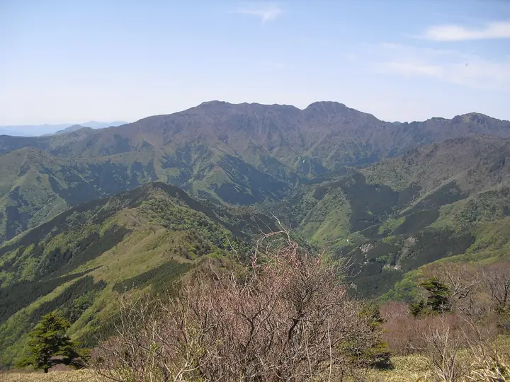
An 1,859.3-meter peak on the border between Kuma-Kōgen Town (Kamiukena District, Ehime) and Ino Town (Agawa District, Kōchi), and one of the principal summits of the Ishizuchi Range in central Shikoku. Its distinctive dome shape is recognisable from far across the range; the summit itself is a gentle sasa-grass meadow studded with rhododendron, ringed on three sides by steep cliffs and reached by a forty-meter chain pitch near the top. Long revered as a Shugendō training mountain, it carries Ōyamatsumi-jinja and Gongen-sha at the summit and a Shingon-related practice hall at Tebako-goe (1,720 m) on the eastern saddle. Within the Ishizuchi-sankei Forest Ecosystem Protection Area, it is listed in the Shikoku 100 Famous Mountains, the Bunken Tozan Guides for Ehime and Kōchi, Nihon no Yama 1000 and Ehime Yūyū Yamaaruki.
Mt. Tsutsujō at a glance
- Weather: The most settled day in the next 7 days is Sun, November 8: clear, gusts up to 6 m/s. Fri, Nov 6: strong wind (gusts up to 17 m/s).
- Route: The shortest is Ishizuchi Range Loop from Tsuchigoya over Iwaguro, Tebako and Tsutsujo, Three Peaks Facing Ishizuchi: about 6 h 44 min, 11.1 km, about 870 m of climbing.
Mt. Tsutsujō weather (hourly, 14 days)
Sunrise today 06:28, sunset 17:14
| Tue, 11/3 | Wed, 11/4 | Thu, 11/5 | Fri, 11/6 | Sat, 11/7 | Sun, 11/8 | Mon, 11/9 | Tue, 11/10 | Wed, 11/11 | Thu, 11/12 | Fri, 11/13 | Sat, 11/14 | Sun, 11/15 | Mon, 11/16 | Tue, 11/17 | |||||||||||||||||||||||||||||||||||||||||||||||||||||||||||||||||||||||
|---|---|---|---|---|---|---|---|---|---|---|---|---|---|---|---|---|---|---|---|---|---|---|---|---|---|---|---|---|---|---|---|---|---|---|---|---|---|---|---|---|---|---|---|---|---|---|---|---|---|---|---|---|---|---|---|---|---|---|---|---|---|---|---|---|---|---|---|---|---|---|---|---|---|---|---|---|---|---|---|---|---|---|---|---|---|
| Japan time | 15 | 17 | 19 | 21 | 23 | 1 | 3 | 5 | 7 | 9 | 11 | 13 | 15 | 18 | 21 | 0 | 3 | 6 | 9 | 12 | 15 | 18 | 21 | 0 | 3 | 6 | 9 | 12 | 15 | 18 | 21 | 0 | 3 | 6 | 9 | 12 | 15 | 18 | 21 | 0 | 3 | 6 | 9 | 12 | 15 | 18 | 21 | 0 | 3 | 6 | 9 | 15 | 21 | 3 | 9 | 15 | 21 | 3 | 9 | 15 | 21 | 3 | 9 | 15 | 21 | 3 | 9 | 15 | 21 | 3 | 9 | 15 | 21 | 3 | 9 | 15 | 21 | 3 | 9 | 15 | 21 | 3 | 9 | 15 | |
  |   |   | |   |   | | |   | | | | | |   | | | |   |   | | | | | | | | |  |  | | | | | | | | | | | | | | | | | | | | | | | | | |   |   | | | | | | | | | | | |  | | | | | | | | | | | | |   | | | ||
| Temperature | °C | 9° | 5° | 4° | 2° | 4° | 4° | 3° | 3° | 3° | 7° | 8° | 9° | 10° | 6° | 7° | 7° | 8° | 8° | 10° | 14° | 12° | 10° | 10° | 10° | 8° | 7° | 6° | 9° | 8° | 3° | 1° | 0° | 0° | -1° | 1° | 4° | 4° | -1° | -3° | -3° | -2° | -1° | 5° | 8° | 7° | 3° | 3° | 3° | 3° | 2° | 5° | 7° | 1° | -2° | 4° | 5° | -1° | -2° | -1° | 3° | -2° | -1° | 3° | 6° | 0° | -1° | 3° | 5° | -1° | -2° | 6° | 9° | 2° | 3° | 6° | 8° | 7° | 8° | 7° | 8° | 3° | -1° | 2° | 6° |
| Precipitation | mm | 0.4 | 0.4 | 0.3 | 1.0 | 0.7 | 0.1 | 1.4 | 0.2 | 2.4 | 1.9 | 1.6 | 0.3 | 0.2 | 0.2 | 0.5 | 0.8 | 0.6 | 0.3 | 0.1 | 0.3 | 2.1 | 5 | 0.7 | 0.6 | 1.4 | 1.3 | 0.1 | |||||||||||||||||||||||||||||||||||||||||||||||||||||||||
| New snow | cm | ||||||||||||||||||||||||||||||||||||||||||||||||||||||||||||||||||||||||||||||||||||
| Snow depth | cm | 0 | 0 | 0 | 0 | 0 | 0 | 0 | 0 | 0 | 0 | 0 | 0 | 0 | 0 | 0 | 0 | 0 | 0 | 0 | 0 | 0 | 0 | 0 | 0 | 0 | 0 | 0 | 0 | 0 | 0 | 0 | 0 | 0 | 0 | 0 | 0 | 0 | 0 | 0 | 0 | 0 | 0 | 0 | 0 | 0 | 0 | 0 | 0 | 0 | 0 | 0 | 0 | 0 | 0 | 0 | 0 | 0 | 0 | 0 | 0 | 0 | 0 | 0 | 0 | 0 | 0 | 0 | 0 | 0 | 0 | 0 | 0 | 0 | 0 | 0 | 0 | 0 | 0 | 0 | 0 | 0 | 0 | 0 | 0 |
| Wind | m/s | 2 | 1 | 1 | 1 | 1 | 1 | 1 | 2 | 2 | 1 | 1 | 1 | 1 | 1 | 1 | 2 | 0 | 1 | 1 | 2 | 2 | 2 | 1 | 4 | 4 | 4 | 4 | 5 | 5 | 4 | 4 | 4 | 4 | 4 | 4 | 4 | 3 | 2 | 1 | 1 | 1 | 1 | 2 | 1 | 1 | 1 | 1 | 0 | 1 | 1 | 2 | 3 | 1 | 1 | 2 | 4 | 4 | 6 | 4 | 3 | 1 | 1 | 1 | 3 | 1 | 2 | 3 | 3 | 2 | 1 | 1 | 1 | 1 | 2 | 3 | 4 | 2 | 3 | 4 | 5 | 3 | 2 | 2 | 2 |
| Wind gusts | m/s | 8 | 7 | 4 | 4 | 4 | 4 | 4 | 5 | 5 | 5 | 5 | 5 | 5 | 5 | 5 | 7 | 7 | 4 | 5 | 7 | 8 | 8 | 8 | 14 | 14 | 13 | 14 | 16 | 17 | 16 | 14 | 13 | 14 | 13 | 13 | 13 | 12 | 10 | 7 | 6 | 5 | 6 | 6 | 6 | 5 | 5 | 3 | 3 | 4 | 5 | 7 | 10 | 9 | 5 | 8 | 13 | 13 | 16 | 16 | 13 | 10 | 5 | 5 | 8 | 8 | 9 | 10 | 10 | 8 | 6 | 5 | 6 | 6 | 7 | 11 | 14 | 14 | 12 | 12 | 14 | 13 | 9 | 6 | 7 |
| Wind dir. | ↓ | ↓ | ↓ | ↓ | ↓ | ↓ | ↓ | ↓ | ↓ | ↓ | ↓ | ↓ | ↓ | ↓ | ↓ | ↓ | ↓ | ↓ | ↓ | ↓ | ↓ | ↓ | ↓ | ↓ | ↓ | ↓ | ↓ | ↓ | ↓ | ↓ | ↓ | ↓ | ↓ | ↓ | ↓ | ↓ | ↓ | ↓ | ↓ | ↓ | ↓ | ↓ | ↓ | ↓ | ↓ | ↓ | ↓ | ↓ | ↓ | ↓ | ↓ | ↓ | ↓ | ↓ | ↓ | ↓ | ↓ | ↓ | ↓ | ↓ | ↓ | ↓ | ↓ | ↓ | ↓ | ↓ | ↓ | ↓ | ↓ | ↓ | ↓ | ↓ | ↓ | ↓ | ↓ | ↓ | ↓ | ↓ | ↓ | ↓ | ↓ | ↓ | ↓ | ↓ | |
Mt. Tsutsujō hiking routes
Hiking times are estimates calculated from the terrain.
Huts, campsites and lodging near Mt. Tsutsujō
Mountain huts
- 丸滝小屋 unstaffed
- 白石ロッジ temporarily closed
- 山荘しらさ 2026: open April 5–November 25 · reservation required · sleeps 21
- シラサ小屋 unstaffed
Campsites
- 白猪谷オートキャンプ場
Lodging
- 国民宿舎石鎚
Lists that include Mt. Tsutsujō
Shikoku 100 Famous Mountains · Elevations of 1003 Mountains of Japan · 1000 Mountains of Japan
Mt. Tsutsujō facts
- Elevation
- 1,859 m
- Location
- Kumakogen, Ehime / Ino, Kochi / Niyodogawa, Kochi
33.731942, 133.161104 - Website
- www.town.niyodogawa.lg.jp
- Wikipedia
- ja.wikipedia.org