
Mt. Ninomori
二ノ森
Kumakogen, Ehime / Saijo, Ehime · Elevation 1,930 m
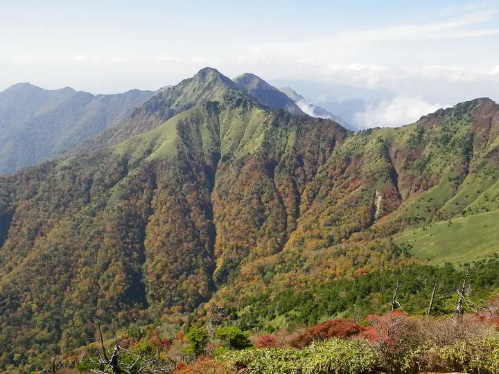
Mt. Ninomori is a 1,929.6 m peak straddling the boundary between Saijō City and Kumakōgen Town in Ehime Prefecture, the second-highest summit of Ehime after Mt. Ishizuchi and the fourth-highest in all of Shikoku. Its summit carries a first-class triangulation point named Omogo-yama and stands on the central ridge of the Ishizuchi Range — west of Mt. Ishizuchi and east of Mt. Dōgamori — within Ishizuchi Quasi-National Park. The peak is typically reached from the Hōino trailhead in Saijō's Tanbara district via Mt. Dōgamori (1,689 m) and Kuraze-no-Kashira (1,889 m), or by traversing west from Mt. Ishizuchi's summit via Mt. Nishi-no-Kanmuri (1,894 m); both are demanding traverses exceeding six hours one-way. It appears in the One Hundred First-Class Triangulation Mountains, Shikoku 100 Famous Mountains, Japan 1000 Mountains, Shikoku 100 Mountains, Ehime Mountain Guide, Japan 1003 Elevation Mountains, and Ehime Yūyū Mountain Walks.
Mt. Ninomori at a glance
- Weather: The most settled day in the next 7 days is Sun, November 8: clear, gusts up to 8 m/s. Fri, Nov 6: strong wind (gusts up to 16 m/s).
Mt. Ninomori weather (hourly, 14 days)
Sunrise today 06:28, sunset 17:15
| Tue, 11/3 | Wed, 11/4 | Thu, 11/5 | Fri, 11/6 | Sat, 11/7 | Sun, 11/8 | Mon, 11/9 | Tue, 11/10 | Wed, 11/11 | Thu, 11/12 | Fri, 11/13 | Sat, 11/14 | Sun, 11/15 | Mon, 11/16 | Tue, 11/17 | |||||||||||||||||||||||||||||||||||||||||||||||||||||||||||||||||||||||
|---|---|---|---|---|---|---|---|---|---|---|---|---|---|---|---|---|---|---|---|---|---|---|---|---|---|---|---|---|---|---|---|---|---|---|---|---|---|---|---|---|---|---|---|---|---|---|---|---|---|---|---|---|---|---|---|---|---|---|---|---|---|---|---|---|---|---|---|---|---|---|---|---|---|---|---|---|---|---|---|---|---|---|---|---|---|
| Japan time | 15 | 17 | 19 | 21 | 23 | 1 | 3 | 5 | 7 | 9 | 11 | 13 | 15 | 18 | 21 | 0 | 3 | 6 | 9 | 12 | 15 | 18 | 21 | 0 | 3 | 6 | 9 | 12 | 15 | 18 | 21 | 0 | 3 | 6 | 9 | 12 | 15 | 18 | 21 | 0 | 3 | 6 | 9 | 12 | 15 | 18 | 21 | 0 | 3 | 6 | 9 | 15 | 21 | 3 | 9 | 15 | 21 | 3 | 9 | 15 | 21 | 3 | 9 | 15 | 21 | 3 | 9 | 15 | 21 | 3 | 9 | 15 | 21 | 3 | 9 | 15 | 21 | 3 | 9 | 15 | 21 | 3 | 9 | 15 | |
  | |   | |   | | | |   |   | | | | |   | | |   |   | | | | | | | | |   |  |  | | |   | | | | | | | | | | | | | | | | | | | | | | | |   | | | | | | | | | | | |  | | | | | |   | | | | | | | | | | ||
| Temperature | °C | 7° | 4° | 2° | 1° | 2° | 2° | 2° | 2° | 1° | 5° | 6° | 7° | 8° | 4° | 5° | 5° | 6° | 6° | 8° | 13° | 11° | 9° | 8° | 8° | 6° | 5° | 5° | 7° | 7° | 2° | -1° | -2° | -2° | -2° | 0° | 3° | 3° | -3° | -4° | -4° | -4° | -3° | 3° | 6° | 5° | 2° | 1° | 1° | 1° | 0° | 4° | 6° | 0° | -3° | 2° | 3° | -2° | -3° | -2° | 2° | -4° | -4° | 1° | 4° | -1° | -3° | 1° | 3° | -2° | -3° | 4° | 8° | 0° | 2° | 5° | 6° | 5° | 6° | 5° | 7° | 1° | -2° | 1° | 5° |
| Precipitation | mm | 0.2 | 0.2 | 0.2 | 1.1 | 0.6 | 0.1 | 1.2 | 1.0 | 2.7 | 1.9 | 0.4 | 0.2 | 0.2 | 0.1 | 0.6 | 0.8 | 0.4 | 0.2 | 0.2 | 1.7 | 5 | 1.6 | 0.9 | 2.0 | 1.2 | |||||||||||||||||||||||||||||||||||||||||||||||||||||||||||
| New snow | cm | ||||||||||||||||||||||||||||||||||||||||||||||||||||||||||||||||||||||||||||||||||||
| Snow depth | cm | 0 | 0 | 0 | 0 | 0 | 0 | 0 | 0 | 0 | 0 | 0 | 0 | 0 | 0 | 0 | 0 | 0 | 0 | 0 | 0 | 0 | 0 | 0 | 0 | 0 | 0 | 0 | 0 | 0 | 0 | 0 | 0 | 0 | 0 | 0 | 0 | 0 | 0 | 0 | 0 | 0 | 0 | 0 | 0 | 0 | 0 | 0 | 0 | 0 | 0 | 0 | 0 | 0 | 0 | 0 | 0 | 0 | 0 | 0 | 0 | 0 | 0 | 0 | 0 | 0 | 0 | 0 | 0 | 0 | 0 | 0 | 0 | 0 | 0 | 0 | 0 | 0 | 0 | 0 | 0 | 0 | 0 | 0 | 0 |
| Wind | m/s | 3 | 1 | 1 | 2 | 2 | 2 | 2 | 2 | 3 | 2 | 2 | 1 | 1 | 1 | 1 | 2 | 0 | 1 | 1 | 2 | 2 | 2 | 2 | 4 | 4 | 4 | 4 | 5 | 5 | 4 | 3 | 3 | 4 | 4 | 4 | 4 | 3 | 2 | 2 | 2 | 2 | 2 | 3 | 1 | 1 | 2 | 1 | 1 | 1 | 1 | 2 | 3 | 2 | 1 | 2 | 4 | 3 | 5 | 5 | 4 | 1 | 1 | 1 | 2 | 1 | 2 | 3 | 3 | 3 | 2 | 0 | 1 | 2 | 2 | 4 | 5 | 2 | 2 | 3 | 5 | 4 | 3 | 2 | 2 |
| Wind gusts | m/s | 10 | 8 | 5 | 5 | 6 | 6 | 6 | 7 | 8 | 7 | 7 | 7 | 6 | 6 | 5 | 7 | 7 | 4 | 4 | 6 | 9 | 7 | 7 | 13 | 13 | 13 | 13 | 15 | 16 | 15 | 12 | 11 | 12 | 12 | 13 | 13 | 12 | 10 | 7 | 6 | 6 | 7 | 8 | 8 | 6 | 5 | 4 | 4 | 3 | 4 | 7 | 10 | 9 | 4 | 6 | 12 | 12 | 16 | 16 | 14 | 10 | 5 | 4 | 8 | 7 | 8 | 10 | 12 | 9 | 8 | 6 | 7 | 6 | 7 | 12 | 15 | 15 | 10 | 10 | 14 | 14 | 11 | 8 | 7 |
| Wind dir. | ↓ | ↓ | ↓ | ↓ | ↓ | ↓ | ↓ | ↓ | ↓ | ↓ | ↓ | ↓ | ↓ | ↓ | ↓ | ↓ | ↓ | ↓ | ↓ | ↓ | ↓ | ↓ | ↓ | ↓ | ↓ | ↓ | ↓ | ↓ | ↓ | ↓ | ↓ | ↓ | ↓ | ↓ | ↓ | ↓ | ↓ | ↓ | ↓ | ↓ | ↓ | ↓ | ↓ | ↓ | ↓ | ↓ | ↓ | ↓ | ↓ | ↓ | ↓ | ↓ | ↓ | ↓ | ↓ | ↓ | ↓ | ↓ | ↓ | ↓ | ↓ | ↓ | ↓ | ↓ | ↓ | ↓ | ↓ | ↓ | ↓ | ↓ | ↓ | ↓ | ↓ | ↓ | ↓ | ↓ | ↓ | ↓ | ↓ | ↓ | ↓ | ↓ | ↓ | ↓ | |
Huts, campsites and lodging near Mt. Ninomori
Mountain huts
- 愛大石鎚小屋 unstaffed
- 石鎚神社頂上山荘 2024: open May 1–November 3 · reservation required · sleeps 25
- 堂ヶ森避難小屋 unstaffed
- 石鎚山公衆トイレ休憩所 unstaffed
Campsites
- 面河第一キャンプ場
Lodging
- 国民宿舎面河
- 国民宿舎石鎚
Lists that include Mt. Ninomori
100 Famous Mountains with First-order Triangulation Points · Shikoku 100 Famous Mountains · Elevations of 1003 Mountains of Japan · 1000 Mountains of Japan
Mt. Ninomori facts
- Elevation
- 1,930 m
- Location
- Kumakogen, Ehime / Saijo, Ehime
33.758572, 133.093856 - National Park
- 石鎚国定公園
- Website
- ishizuchisankei.com
- Trail Map
- ishizuchisankei.com (PDF)
- Access Information
- ishizuchisankei.com
- Wikipedia
- ja.wikipedia.org