
Mount Ishizuchi
石鎚山
Saijo, Ehime · Elevation 1,982 m
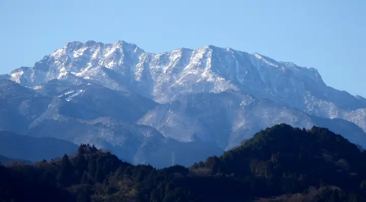
Mount Ishizuchi (Tengu-dake, 1,982 m) is the highest peak of western Japan, straddling Saijō City and Kumakōgen Town in Ehime Prefecture and the dominant peak of Shikoku. The summit area comprises Misen, Tengu-dake and Nanseppō, and forms the heart of Ishizuchi Quasi-National Park. One of the Seven Sacred Mountains of Japan, it has been a center of Shugendō mountain ascetic practice for over a millennium, with the July "Oyamabiraki Taisai" pilgrimage drawing white-clad worshippers up the famed kusari (chain) sections. The Jōju route via the ropeway and the Tsuchigoya route are the most popular approaches.
Mount Ishizuchi at a glance
- Weather: The most settled day in the next 7 days is Sun, November 8: clear, gusts up to 6 m/s. Fri, Nov 6: strong wind (gusts up to 17 m/s).
- Route: The shortest is Mount Ishizuchi Return from Tsuchigoya along the Ridge to Misen's Summit Shrine: about 5 h 13 min, 8.8 km, about 610 m of climbing.
Mount Ishizuchi weather (hourly, 14 days)
Sunrise today 06:28, sunset 17:15
| Tue, 11/3 | Wed, 11/4 | Thu, 11/5 | Fri, 11/6 | Sat, 11/7 | Sun, 11/8 | Mon, 11/9 | Tue, 11/10 | Wed, 11/11 | Thu, 11/12 | Fri, 11/13 | Sat, 11/14 | Sun, 11/15 | Mon, 11/16 | Tue, 11/17 | |||||||||||||||||||||||||||||||||||||||||||||||||||||||||||||||||||||||
|---|---|---|---|---|---|---|---|---|---|---|---|---|---|---|---|---|---|---|---|---|---|---|---|---|---|---|---|---|---|---|---|---|---|---|---|---|---|---|---|---|---|---|---|---|---|---|---|---|---|---|---|---|---|---|---|---|---|---|---|---|---|---|---|---|---|---|---|---|---|---|---|---|---|---|---|---|---|---|---|---|---|---|---|---|---|
| Japan time | 15 | 17 | 19 | 21 | 23 | 1 | 3 | 5 | 7 | 9 | 11 | 13 | 15 | 18 | 21 | 0 | 3 | 6 | 9 | 12 | 15 | 18 | 21 | 0 | 3 | 6 | 9 | 12 | 15 | 18 | 21 | 0 | 3 | 6 | 9 | 12 | 15 | 18 | 21 | 0 | 3 | 6 | 9 | 12 | 15 | 18 | 21 | 0 | 3 | 6 | 9 | 15 | 21 | 3 | 9 | 15 | 21 | 3 | 9 | 15 | 21 | 3 | 9 | 15 | 21 | 3 | 9 | 15 | 21 | 3 | 9 | 15 | 21 | 3 | 9 | 15 | 21 | 3 | 9 | 15 | 21 | 3 | 9 | 15 | |
  |   |   | |   |   | | |   | | | | | |   | | | |   |   | | | | | | | | |  |  | | | | | | | | | | | | | | | | | | | | | | | | | |   |   | | | | | | | | | | | |  | | | | | | | | | | | | |   | | | ||
| Temperature | °C | 8° | 4° | 3° | 2° | 3° | 3° | 3° | 2° | 2° | 6° | 7° | 8° | 9° | 5° | 6° | 7° | 7° | 8° | 9° | 14° | 12° | 9° | 9° | 9° | 7° | 6° | 5° | 8° | 7° | 3° | 0° | -1° | -1° | -2° | 1° | 3° | 3° | -2° | -3° | -4° | -3° | -2° | 4° | 7° | 6° | 3° | 3° | 2° | 2° | 1° | 5° | 6° | 0° | -3° | 3° | 4° | -1° | -3° | -2° | 2° | -3° | -2° | 2° | 5° | -1° | -2° | 2° | 4° | -2° | -3° | 5° | 8° | 2° | 2° | 6° | 7° | 6° | 7° | 6° | 7° | 2° | -1° | 2° | 6° |
| Precipitation | mm | 0.4 | 0.4 | 0.3 | 1.0 | 0.7 | 0.1 | 1.4 | 0.2 | 2.4 | 1.9 | 1.6 | 0.3 | 0.2 | 0.2 | 0.5 | 0.8 | 0.6 | 0.3 | 0.1 | 0.3 | 2.1 | 5 | 0.7 | 0.6 | 1.4 | 1.3 | 0.1 | |||||||||||||||||||||||||||||||||||||||||||||||||||||||||
| New snow | cm | ||||||||||||||||||||||||||||||||||||||||||||||||||||||||||||||||||||||||||||||||||||
| Snow depth | cm | 0 | 0 | 0 | 0 | 0 | 0 | 0 | 0 | 0 | 0 | 0 | 0 | 0 | 0 | 0 | 0 | 0 | 0 | 0 | 0 | 0 | 0 | 0 | 0 | 0 | 0 | 0 | 0 | 0 | 0 | 0 | 0 | 0 | 0 | 0 | 0 | 0 | 0 | 0 | 0 | 0 | 0 | 0 | 0 | 0 | 0 | 0 | 0 | 0 | 0 | 0 | 0 | 0 | 0 | 0 | 0 | 0 | 0 | 0 | 0 | 0 | 0 | 0 | 0 | 0 | 0 | 0 | 0 | 0 | 0 | 0 | 0 | 0 | 0 | 0 | 0 | 0 | 0 | 0 | 0 | 0 | 0 | 0 | 0 |
| Wind | m/s | 2 | 1 | 1 | 1 | 1 | 1 | 1 | 2 | 2 | 1 | 1 | 1 | 1 | 1 | 1 | 2 | 0 | 1 | 1 | 2 | 2 | 2 | 1 | 4 | 4 | 4 | 4 | 5 | 5 | 4 | 4 | 4 | 4 | 4 | 4 | 4 | 3 | 2 | 1 | 1 | 1 | 1 | 2 | 1 | 1 | 1 | 1 | 0 | 1 | 1 | 2 | 3 | 1 | 1 | 2 | 4 | 4 | 6 | 4 | 3 | 1 | 1 | 1 | 3 | 1 | 2 | 3 | 3 | 2 | 1 | 1 | 1 | 1 | 2 | 3 | 4 | 2 | 3 | 4 | 5 | 3 | 2 | 2 | 2 |
| Wind gusts | m/s | 8 | 7 | 4 | 4 | 4 | 4 | 4 | 5 | 5 | 5 | 5 | 5 | 5 | 5 | 5 | 7 | 7 | 4 | 5 | 7 | 8 | 8 | 8 | 14 | 14 | 13 | 14 | 16 | 17 | 16 | 14 | 13 | 14 | 13 | 13 | 13 | 12 | 10 | 7 | 6 | 5 | 6 | 6 | 6 | 5 | 5 | 3 | 3 | 4 | 5 | 7 | 10 | 9 | 5 | 8 | 13 | 13 | 16 | 16 | 13 | 10 | 5 | 5 | 8 | 8 | 9 | 10 | 10 | 8 | 6 | 5 | 6 | 6 | 7 | 11 | 14 | 14 | 12 | 12 | 14 | 13 | 9 | 6 | 7 |
| Wind dir. | ↓ | ↓ | ↓ | ↓ | ↓ | ↓ | ↓ | ↓ | ↓ | ↓ | ↓ | ↓ | ↓ | ↓ | ↓ | ↓ | ↓ | ↓ | ↓ | ↓ | ↓ | ↓ | ↓ | ↓ | ↓ | ↓ | ↓ | ↓ | ↓ | ↓ | ↓ | ↓ | ↓ | ↓ | ↓ | ↓ | ↓ | ↓ | ↓ | ↓ | ↓ | ↓ | ↓ | ↓ | ↓ | ↓ | ↓ | ↓ | ↓ | ↓ | ↓ | ↓ | ↓ | ↓ | ↓ | ↓ | ↓ | ↓ | ↓ | ↓ | ↓ | ↓ | ↓ | ↓ | ↓ | ↓ | ↓ | ↓ | ↓ | ↓ | ↓ | ↓ | ↓ | ↓ | ↓ | ↓ | ↓ | ↓ | ↓ | ↓ | ↓ | ↓ | ↓ | ↓ | |
Mount Ishizuchi hiking routes
- Mount Ishizuchi Return from Tsuchigoya along the Ridge to Misen's Summit Shrine 8.8 km · Ascent 611 m 石鎚土小屋 (Bus stop) (parking)
- Mount Ishizuchi Joju Route to Misen Out-and-Back 8.6 km · Ascent 899 m 石鎚観光リフト 成就駅 (Aerialway station), 山頂成就駅 (Aerialway station)
Hiking times are estimates calculated from the terrain.
Huts, campsites and lodging near Mount Ishizuchi
Mountain huts
- 石鎚神社頂上山荘 2024: open May 1–November 3 · reservation required · sleeps 25
- 石鎚山公衆トイレ休憩所 unstaffed
- 愛大石鎚小屋 unstaffed
- 白石ロッジ temporarily closed
- 堂ヶ森避難小屋 unstaffed
Campsites
- 面河第一キャンプ場
Lodging
- 国民宿舎石鎚
Lists that include Mount Ishizuchi
100 Famous Japanese Mountains · Japan 200 Famous Mountains · Japan's 300 Famous Mountains · 100 Famous Mountains of Flowers · New 100 Famous Flower Mountains · New Japan 100 Famous Mountains · Highest Peaks by Prefecture · Illustrated Collection of Japan's Famous Mountains · Shikoku 100 Famous Mountains · Elevations of 1003 Mountains of Japan · 1000 Mountains of Japan
Mount Ishizuchi facts
- Also known as
- 天狗岳
- Elevation
- 1,982 m
- Location
- Saijo, Ehime
33.767781, 133.115104 - National Park
- 石鎚国定公園
- Website
- www.iyokannet.jp
- Trail Map
- ishizuchisankei.com (PDF)
- Access Information
- ishizuchisankei.com
- Wikipedia
- ja.wikipedia.org