
Mt. Kamegamori
瓶ヶ森
Saijo, Ehime · Elevation 1,896 m
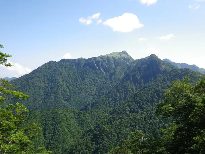
Mt. Kamegamori (1,896 m) straddles the border of Saijō City in Ehime and Ino Town in Kōchi within Ishizuchi Quasi-National Park, ranking as the second-highest summit of the Ishizuchi Range after Mt. Ishizuchi itself. Its broad summit plateau is carpeted in dwarf bamboo grass and crowned by twin peaks—the lower Otokoyama and the higher Onnayama—offering sweeping views of Mt. Ishizuchi and the surrounding ridges. Easily reached via the Kamegamori Forest Road (the so-called "UFO Line") that runs along the ridge near the summit, it is counted among Japan's 300 Famous Mountains and the 100 Famous Mountains of Shikoku.
Mt. Kamegamori at a glance
- Weather: The most settled day in the next 7 days is Sun, November 8: clear, gusts up to 6 m/s. Fri, Nov 6: strong wind (gusts up to 17 m/s).
- Route: The shortest is Mount Kamegamori Loop via Oyama and Meyama: about 1 h 33 min, 2.5 km, about 220 m of climbing.
Mt. Kamegamori weather (hourly, 14 days)
Sunrise today 06:27, sunset 17:14
| Tue, 11/3 | Wed, 11/4 | Thu, 11/5 | Fri, 11/6 | Sat, 11/7 | Sun, 11/8 | Mon, 11/9 | Tue, 11/10 | Wed, 11/11 | Thu, 11/12 | Fri, 11/13 | Sat, 11/14 | Sun, 11/15 | Mon, 11/16 | Tue, 11/17 | |||||||||||||||||||||||||||||||||||||||||||||||||||||||||||||||||||||||
|---|---|---|---|---|---|---|---|---|---|---|---|---|---|---|---|---|---|---|---|---|---|---|---|---|---|---|---|---|---|---|---|---|---|---|---|---|---|---|---|---|---|---|---|---|---|---|---|---|---|---|---|---|---|---|---|---|---|---|---|---|---|---|---|---|---|---|---|---|---|---|---|---|---|---|---|---|---|---|---|---|---|---|---|---|---|
| Japan time | 15 | 17 | 19 | 21 | 23 | 1 | 3 | 5 | 7 | 9 | 11 | 13 | 15 | 18 | 21 | 0 | 3 | 6 | 9 | 12 | 15 | 18 | 21 | 0 | 3 | 6 | 9 | 12 | 15 | 18 | 21 | 0 | 3 | 6 | 9 | 12 | 15 | 18 | 21 | 0 | 3 | 6 | 9 | 12 | 15 | 18 | 21 | 0 | 3 | 6 | 9 | 15 | 21 | 3 | 9 | 15 | 21 | 3 | 9 | 15 | 21 | 3 | 9 | 15 | 21 | 3 | 9 | 15 | 21 | 3 | 9 | 15 | 21 | 3 | 9 | 15 | 21 | 3 | 9 | 15 | 21 | 3 | 9 | 15 | |
  |   |   | |   |   | | |   | | | | | |   | | | |   |   | | | | | | | | |  |  | | | | | | | | | | | | | | | | | | | | | | | | | |   |   | | | | | | | | | | | |  | | | | | | | | | | | | |   | | | ||
| Temperature | °C | 8° | 5° | 4° | 2° | 3° | 3° | 3° | 3° | 3° | 7° | 7° | 8° | 10° | 6° | 6° | 7° | 8° | 8° | 9° | 14° | 12° | 10° | 10° | 9° | 8° | 6° | 6° | 9° | 8° | 3° | 0° | 0° | 0° | -2° | 1° | 4° | 4° | -2° | -3° | -3° | -3° | -2° | 5° | 8° | 7° | 3° | 3° | 3° | 3° | 2° | 5° | 7° | 1° | -2° | 3° | 5° | -1° | -2° | -1° | 3° | -2° | -2° | 3° | 5° | 0° | -2° | 3° | 5° | -1° | -2° | 6° | 9° | 2° | 3° | 6° | 8° | 7° | 8° | 7° | 8° | 3° | -1° | 2° | 6° |
| Precipitation | mm | 0.4 | 0.4 | 0.3 | 1.0 | 0.7 | 0.1 | 1.4 | 0.2 | 2.4 | 1.9 | 1.6 | 0.3 | 0.2 | 0.2 | 0.5 | 0.8 | 0.6 | 0.3 | 0.1 | 0.3 | 2.1 | 5 | 0.7 | 0.6 | 1.4 | 1.3 | 0.1 | |||||||||||||||||||||||||||||||||||||||||||||||||||||||||
| New snow | cm | ||||||||||||||||||||||||||||||||||||||||||||||||||||||||||||||||||||||||||||||||||||
| Snow depth | cm | 0 | 0 | 0 | 0 | 0 | 0 | 0 | 0 | 0 | 0 | 0 | 0 | 0 | 0 | 0 | 0 | 0 | 0 | 0 | 0 | 0 | 0 | 0 | 0 | 0 | 0 | 0 | 0 | 0 | 0 | 0 | 0 | 0 | 0 | 0 | 0 | 0 | 0 | 0 | 0 | 0 | 0 | 0 | 0 | 0 | 0 | 0 | 0 | 0 | 0 | 0 | 0 | 0 | 0 | 0 | 0 | 0 | 0 | 0 | 0 | 0 | 0 | 0 | 0 | 0 | 0 | 0 | 0 | 0 | 0 | 0 | 0 | 0 | 0 | 0 | 0 | 0 | 0 | 0 | 0 | 0 | 0 | 0 | 0 |
| Wind | m/s | 2 | 1 | 1 | 1 | 1 | 1 | 1 | 2 | 2 | 1 | 1 | 1 | 1 | 1 | 1 | 2 | 0 | 1 | 1 | 2 | 2 | 2 | 1 | 4 | 4 | 4 | 4 | 5 | 5 | 4 | 4 | 4 | 4 | 4 | 4 | 4 | 3 | 2 | 1 | 1 | 1 | 1 | 2 | 1 | 1 | 1 | 1 | 0 | 1 | 1 | 2 | 3 | 1 | 1 | 2 | 4 | 4 | 6 | 4 | 3 | 1 | 1 | 1 | 3 | 1 | 2 | 3 | 3 | 2 | 1 | 1 | 1 | 1 | 2 | 3 | 4 | 2 | 3 | 4 | 5 | 3 | 2 | 2 | 2 |
| Wind gusts | m/s | 8 | 7 | 4 | 4 | 4 | 4 | 4 | 5 | 5 | 5 | 5 | 5 | 5 | 5 | 5 | 7 | 7 | 4 | 5 | 7 | 8 | 8 | 8 | 14 | 14 | 13 | 14 | 16 | 17 | 16 | 14 | 13 | 14 | 13 | 13 | 13 | 12 | 10 | 7 | 6 | 5 | 6 | 6 | 6 | 5 | 5 | 3 | 3 | 4 | 5 | 7 | 10 | 9 | 5 | 8 | 13 | 13 | 16 | 16 | 13 | 10 | 5 | 5 | 8 | 8 | 9 | 10 | 10 | 8 | 6 | 5 | 6 | 6 | 7 | 11 | 14 | 14 | 12 | 12 | 14 | 13 | 9 | 6 | 7 |
| Wind dir. | ↓ | ↓ | ↓ | ↓ | ↓ | ↓ | ↓ | ↓ | ↓ | ↓ | ↓ | ↓ | ↓ | ↓ | ↓ | ↓ | ↓ | ↓ | ↓ | ↓ | ↓ | ↓ | ↓ | ↓ | ↓ | ↓ | ↓ | ↓ | ↓ | ↓ | ↓ | ↓ | ↓ | ↓ | ↓ | ↓ | ↓ | ↓ | ↓ | ↓ | ↓ | ↓ | ↓ | ↓ | ↓ | ↓ | ↓ | ↓ | ↓ | ↓ | ↓ | ↓ | ↓ | ↓ | ↓ | ↓ | ↓ | ↓ | ↓ | ↓ | ↓ | ↓ | ↓ | ↓ | ↓ | ↓ | ↓ | ↓ | ↓ | ↓ | ↓ | ↓ | ↓ | ↓ | ↓ | ↓ | ↓ | ↓ | ↓ | ↓ | ↓ | ↓ | ↓ | ↓ | |
Mt. Kamegamori hiking routes
Hiking times are estimates calculated from the terrain.
Huts, campsites and lodging near Mt. Kamegamori
Mountain huts
- 瓶ヶ森避難小屋 unstaffed
- シラサ小屋 unstaffed
- 山荘しらさ 2026: open April 5–November 25 · reservation required · sleeps 21
Campsites
- 白猪谷オートキャンプ場
Lists that include Mt. Kamegamori
Japan's 300 Famous Mountains · Shikoku 100 Famous Mountains · Elevations of 1003 Mountains of Japan · 1000 Mountains of Japan
Mt. Kamegamori facts
- Also known as
- 女山 · 男山
- Elevation
- 1,896 m
- Location
- Saijo, Ehime
33.794614, 133.193253 - National Park
- 石鎚国定公園
- Website
- ishizuchisankei.com
- Trail Map
- www.pref.ehime.jp (PDF)
- Access Information
- ishizuchisankei.com
- Wikipedia
- ja.wikipedia.org