
Mount Sasagamine
笹ヶ峰
Ino, Kochi · Elevation 1,860 m
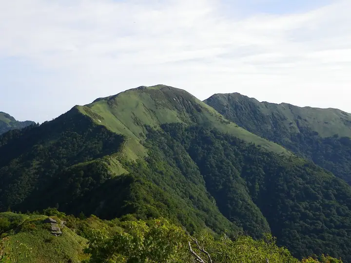
Mount Sasagamine is a 1,860 m peak straddling Saijō City in Ehime Prefecture and Ino Town in Agawa District, Kōchi Prefecture, sitting in the Ishizuchi sub-range at the western end of the Shikoku mountains within Ishizuchi Quasi-National Park. It carries a first-order triangulation marker and is listed in the Nihon Nihyaku Meizan, the Ittō-Sankakuten Hyakumeizan, the Shikoku Hyakumeizan, and the Shikoku Hyakuzan. Its summit ridge is carpeted with miyakozasa bamboo grass — the source of its name — and offers a long, gentle grassland crest with sweeping views across the spine of Shikoku to Mount Ishizuchi, Kamegamori, and the Tsurugi range. The standard ascents are the south-portal traverse from Kanpū-yama Tunnel (Kōchi side) via Kuwase Pass and Kanpū-yama, and the route from the Daiei-yama Tunnel above Besshi-yama on the Niihama side, climbing over Chichi-yama to the summit — both extended ridge walks.
Mount Sasagamine at a glance
- Weather: The most settled day in the next 7 days is Sun, November 8: clear, gusts up to 7 m/s.
- Route: The shortest is Mount Sasagamine in Saijo, Return from the Shimotsuike Forest Road Trailhead via Maruyama Hut: about 4 h 49 min, 6.8 km, about 870 m of climbing.
Mount Sasagamine weather (hourly, 14 days)
Sunrise today 06:27, sunset 17:14
| Tue, 11/3 | Wed, 11/4 | Thu, 11/5 | Fri, 11/6 | Sat, 11/7 | Sun, 11/8 | Mon, 11/9 | Tue, 11/10 | Wed, 11/11 | Thu, 11/12 | Fri, 11/13 | Sat, 11/14 | Sun, 11/15 | Mon, 11/16 | Tue, 11/17 | |||||||||||||||||||||||||||||||||||||||||||||||||||||||||||||||||||||||
|---|---|---|---|---|---|---|---|---|---|---|---|---|---|---|---|---|---|---|---|---|---|---|---|---|---|---|---|---|---|---|---|---|---|---|---|---|---|---|---|---|---|---|---|---|---|---|---|---|---|---|---|---|---|---|---|---|---|---|---|---|---|---|---|---|---|---|---|---|---|---|---|---|---|---|---|---|---|---|---|---|---|---|---|---|---|
| Japan time | 21 | 23 | 1 | 3 | 5 | 7 | 9 | 11 | 13 | 15 | 17 | 19 | 21 | 0 | 3 | 6 | 9 | 12 | 15 | 18 | 21 | 0 | 3 | 6 | 9 | 12 | 15 | 18 | 21 | 0 | 3 | 6 | 9 | 12 | 15 | 18 | 21 | 0 | 3 | 6 | 9 | 12 | 15 | 18 | 21 | 0 | 3 | 6 | 9 | 12 | 15 | 21 | 3 | 9 | 15 | 21 | 3 | 9 | 15 | 21 | 3 | 9 | 15 | 21 | 3 | 9 | 15 | 21 | 3 | 9 | 15 | 21 | 3 | 9 | 15 | 21 | 3 | 9 | 15 | 21 | 3 | 9 | 15 | 21 | |
  |   | | | |   |   | | | | |   | |   |   | |   | |   | | | | | |  | | |  | | | | |   | | | | | | | | | | | | | | | | | | | | | | | | |   | | | | | | | | | |  | | | | | | | | | | | | | | | |  | ||
| Temperature | °C | 2° | 1° | 2° | 1° | 2° | 2° | 4° | 5° | 6° | 6° | 5° | 4° | 4° | 5° | 5° | 6° | 8° | 10° | 10° | 8° | 8° | 8° | 5° | 4° | 5° | 8° | 7° | 2° | 0° | -1° | -1° | -2° | 0° | 2° | 2° | -2° | -2° | -3° | -4° | -4° | 2° | 4° | 3° | 0° | 1° | 1° | 1° | 1° | 4° | 4° | 4° | 0° | -4° | 3° | 4° | -2° | -2° | -1° | 2° | -2° | -1° | 1° | 4° | -1° | -2° | 2° | 3° | -2° | -4° | 3° | 6° | 1° | 0° | 5° | 7° | 6° | 6° | 5° | 7° | 2° | -2° | 0° | 3° | -3° |
| Precipitation | mm | 0.2 | 2.2 | 1.7 | 0.4 | 4.2 | 1.8 | 2.0 | 0.8 | 0.8 | 0.5 | 0.2 | 0.2 | 0.9 | 1.2 | 0.5 | 0.6 | 0.2 | 1.7 | 4.7 | 0.1 | 0.9 | 1.4 | 2.8 | 0.2 | ||||||||||||||||||||||||||||||||||||||||||||||||||||||||||||
| New snow | cm | ||||||||||||||||||||||||||||||||||||||||||||||||||||||||||||||||||||||||||||||||||||
| Snow depth | cm | 0 | 0 | 0 | 0 | 0 | 0 | 0 | 0 | 0 | 0 | 0 | 0 | 0 | 0 | 0 | 0 | 0 | 0 | 0 | 0 | 0 | 0 | 0 | 0 | 0 | 0 | 0 | 0 | 0 | 0 | 0 | 0 | 0 | 0 | 0 | 0 | 0 | 0 | 0 | 0 | 0 | 0 | 0 | 0 | 0 | 0 | 0 | 0 | 0 | 0 | 0 | 0 | 0 | 0 | 0 | 0 | 0 | 0 | 0 | 0 | 0 | 0 | 0 | 0 | 0 | 0 | 0 | 0 | 0 | 0 | 0 | 0 | 0 | 0 | 0 | 0 | 0 | 0 | 0 | 0 | 0 | 0 | 0 | 0 |
| Wind | m/s | 0 | 1 | 1 | 0 | 0 | 0 | 1 | 1 | 1 | 1 | 0 | 0 | 0 | 1 | 1 | 0 | 0 | 0 | 1 | 1 | 1 | 3 | 2 | 3 | 3 | 5 | 4 | 2 | 2 | 2 | 3 | 3 | 4 | 4 | 3 | 2 | 1 | 1 | 1 | 1 | 1 | 2 | 2 | 0 | 0 | 1 | 1 | 1 | 2 | 2 | 2 | 0 | 0 | 1 | 4 | 2 | 4 | 3 | 2 | 1 | 1 | 1 | 2 | 1 | 0 | 2 | 3 | 0 | 0 | 1 | 1 | 2 | 2 | 2 | 2 | 2 | 1 | 2 | 4 | 3 | 0 | 1 | 2 | 0 |
| Wind gusts | m/s | 2 | 3 | 3 | 3 | 3 | 4 | 3 | 6 | 4 | 4 | 4 | 3 | 3 | 5 | 5 | 4 | 4 | 6 | 6 | 7 | 9 | 12 | 12 | 12 | 12 | 15 | 15 | 13 | 11 | 10 | 11 | 11 | 13 | 13 | 12 | 10 | 7 | 5 | 4 | 3 | 4 | 7 | 7 | 6 | 3 | 5 | 5 | 5 | 6 | 8 | 7 | 7 | 4 | 5 | 11 | 11 | 14 | 14 | 11 | 7 | 3 | 4 | 6 | 6 | 5 | 6 | 9 | 8 | 4 | 4 | 5 | 5 | 7 | 9 | 11 | 12 | 10 | 9 | 12 | 12 | 9 | 4 | 7 | 5 |
| Wind dir. | ↓ | ↓ | ↓ | ↓ | ↓ | ↓ | ↓ | ↓ | ↓ | ↓ | ↓ | ↓ | ↓ | ↓ | ↓ | ↓ | ↓ | ↓ | ↓ | ↓ | ↓ | ↓ | ↓ | ↓ | ↓ | ↓ | ↓ | ↓ | ↓ | ↓ | ↓ | ↓ | ↓ | ↓ | ↓ | ↓ | ↓ | ↓ | ↓ | ↓ | ↓ | ↓ | ↓ | ↓ | ↓ | ↓ | ↓ | ↓ | ↓ | ↓ | ↓ | ↓ | ↓ | ↓ | ↓ | ↓ | ↓ | ↓ | ↓ | ↓ | ↓ | ↓ | ↓ | ↓ | ↓ | ↓ | ↓ | ↓ | ↓ | ↓ | ↓ | ↓ | ↓ | ↓ | ↓ | ↓ | ↓ | ↓ | ↓ | ↓ | ↓ | ↓ | ↓ | ↓ | |
Mount Sasagamine hiking routes
- Mount Sasagamine in Saijo, Return from the Shimotsuike Forest Road Trailhead via Maruyama Hut 6.8 km · Ascent 869 m parking
- Kanpūzan and Sasagamine Circuit from the Old Kanpūzan Tunnel South Portal 10.4 km · Ascent 1,017 m 旧寒風山トンネル南口 (parking)
Hiking times are estimates calculated from the terrain.
Huts, campsites and lodging near Mount Sasagamine
Mountain huts
Lists that include Mount Sasagamine
Japan 200 Famous Mountains · Japan's 300 Famous Mountains · 100 Famous Mountains with First-order Triangulation Points · Shikoku 100 Famous Mountains · Elevations of 1003 Mountains of Japan · 1000 Mountains of Japan
Mount Sasagamine facts
- Elevation
- 1,860 m
- Location
- Ino, Kochi
33.828105, 133.274610 - National Park
- 石鎚国定公園
- Website
- ishizuchisankei.com
- Trail Map
- ishizuchisankei.com (PDF)
- Access Information
- ishizuchisankei.com
- Wikipedia
- ja.wikipedia.org