
Mt. Iyofuji
伊予富士
Ino, Kochi / Saijo, Ehime · Elevation 1,756 m
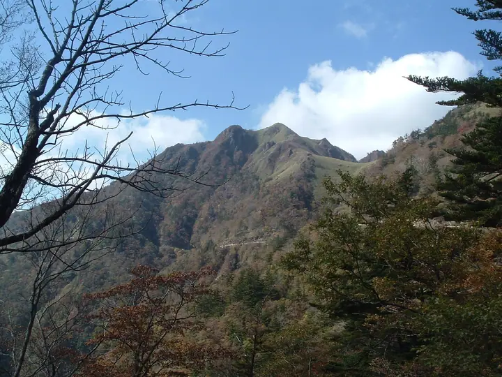
Iyofuji is a 1,756 m peak on the boundary between Saijō City in Ehime Prefecture and Ino Town in Kōchi Prefecture, in the western Ishizuchi Range of the Shikoku Mountains. Its elegant conical silhouette, viewed from the west, gives the mountain its name — "the Fuji of Iyo." The bamboo-grass summit ridge offers a 360-degree panorama north over the Seto Inland Sea and south across the layered Shikoku ranges to Tosa Bay. The standard approach climbs from the Kanpū-jaya or Higashi-Kuromori trailheads on the Kamegamori Forest Road (the so-called "UFO Line"), which is closed each winter from December through early April. The mountain lies within Ishizuchi Quasi-National Park and is listed in the Japanese 300 Famous Mountains, the Shikoku 100, and the Hundred Fuji of Japan, among others.
Mt. Iyofuji at a glance
- Weather: The most settled day in the next 7 days is Sun, November 8: clear, gusts up to 5 m/s.
- Route: The shortest is Mount Iyo-Fuji, Bamboo-Grass Ridge Return from the UFO Line Trailhead: about 1 h 43 min, 2.9 km, about 210 m of climbing.
Mt. Iyofuji weather (hourly, 14 days)
Sunrise today 06:27, sunset 17:14
| Tue, 11/3 | Wed, 11/4 | Thu, 11/5 | Fri, 11/6 | Sat, 11/7 | Sun, 11/8 | Mon, 11/9 | Tue, 11/10 | Wed, 11/11 | Thu, 11/12 | Fri, 11/13 | Sat, 11/14 | Sun, 11/15 | Mon, 11/16 | Tue, 11/17 | |||||||||||||||||||||||||||||||||||||||||||||||||||||||||||||||||||||||
|---|---|---|---|---|---|---|---|---|---|---|---|---|---|---|---|---|---|---|---|---|---|---|---|---|---|---|---|---|---|---|---|---|---|---|---|---|---|---|---|---|---|---|---|---|---|---|---|---|---|---|---|---|---|---|---|---|---|---|---|---|---|---|---|---|---|---|---|---|---|---|---|---|---|---|---|---|---|---|---|---|---|---|---|---|---|
| Japan time | 15 | 17 | 19 | 21 | 23 | 1 | 3 | 5 | 7 | 9 | 11 | 13 | 15 | 18 | 21 | 0 | 3 | 6 | 9 | 12 | 15 | 18 | 21 | 0 | 3 | 6 | 9 | 12 | 15 | 18 | 21 | 0 | 3 | 6 | 9 | 12 | 15 | 18 | 21 | 0 | 3 | 6 | 9 | 12 | 15 | 18 | 21 | 0 | 3 | 6 | 9 | 15 | 21 | 3 | 9 | 15 | 21 | 3 | 9 | 15 | 21 | 3 | 9 | 15 | 21 | 3 | 9 | 15 | 21 | 3 | 9 | 15 | 21 | 3 | 9 | 15 | 21 | 3 | 9 | 15 | 21 | 3 | 9 | 15 | |
  |   |   | |   |   | | |   | | | | | |   | | | |   |   |   | | | | | | | |  |  | | | | | | | | | | | | | | | | | | | | | | | | | | |   | | | | | | | | | | | |  | | | | | | | | | | | | | | | | ||
| Temperature | °C | 8° | 4° | 3° | 2° | 3° | 3° | 3° | 2° | 2° | 7° | 7° | 8° | 9° | 6° | 6° | 7° | 8° | 8° | 9° | 13° | 11° | 9° | 9° | 9° | 8° | 5° | 5° | 8° | 7° | 3° | 0° | -1° | -1° | -2° | 0° | 3° | 3° | -2° | -3° | -3° | -3° | -2° | 4° | 7° | 6° | 3° | 2° | 3° | 3° | 2° | 5° | 6° | 0° | -2° | 3° | 5° | -1° | -2° | -1° | 2° | -2° | -1° | 3° | 5° | -1° | -2° | 2° | 4° | -2° | -3° | 5° | 7° | 2° | 3° | 5° | 7° | 7° | 8° | 6° | 7° | 2° | -1° | 2° | 6° |
| Precipitation | mm | 0.7 | 0.3 | 0.4 | 1.1 | 0.9 | 0.1 | 1.1 | 0.5 | 1.8 | 1.1 | 1.3 | 0.3 | 0.2 | 0.2 | 0.5 | 0.5 | 0.3 | 0.1 | 0.4 | 2.5 | 6 | 0.2 | 0.5 | 0.8 | 1.4 | 0.2 | ||||||||||||||||||||||||||||||||||||||||||||||||||||||||||
| New snow | cm | ||||||||||||||||||||||||||||||||||||||||||||||||||||||||||||||||||||||||||||||||||||
| Snow depth | cm | 0 | 0 | 0 | 0 | 0 | 0 | 0 | 0 | 0 | 0 | 0 | 0 | 0 | 0 | 0 | 0 | 0 | 0 | 0 | 0 | 0 | 0 | 0 | 0 | 0 | 0 | 0 | 0 | 0 | 0 | 0 | 0 | 0 | 0 | 0 | 0 | 0 | 0 | 0 | 0 | 0 | 0 | 0 | 0 | 0 | 0 | 0 | 0 | 0 | 0 | 0 | 0 | 0 | 0 | 0 | 0 | 0 | 0 | 0 | 0 | 0 | 0 | 0 | 0 | 0 | 0 | 0 | 0 | 0 | 0 | 0 | 0 | 0 | 0 | 0 | 0 | 0 | 0 | 0 | 0 | 0 | 0 | 0 | 0 |
| Wind | m/s | 2 | 1 | 1 | 1 | 1 | 1 | 1 | 2 | 1 | 1 | 1 | 1 | 1 | 0 | 1 | 1 | 0 | 0 | 1 | 2 | 2 | 2 | 2 | 3 | 4 | 4 | 4 | 5 | 5 | 4 | 4 | 4 | 4 | 3 | 4 | 4 | 3 | 2 | 2 | 1 | 1 | 1 | 1 | 0 | 0 | 1 | 0 | 0 | 1 | 1 | 2 | 3 | 2 | 2 | 3 | 4 | 5 | 6 | 4 | 3 | 1 | 1 | 1 | 2 | 1 | 3 | 3 | 3 | 2 | 1 | 1 | 2 | 1 | 1 | 3 | 3 | 1 | 3 | 4 | 4 | 3 | 2 | 2 | 1 |
| Wind gusts | m/s | 7 | 7 | 4 | 4 | 3 | 3 | 4 | 4 | 4 | 4 | 4 | 4 | 4 | 4 | 3 | 5 | 5 | 2 | 4 | 7 | 8 | 7 | 7 | 10 | 11 | 12 | 12 | 14 | 15 | 14 | 12 | 12 | 12 | 11 | 12 | 12 | 11 | 10 | 6 | 5 | 5 | 5 | 5 | 5 | 5 | 4 | 2 | 3 | 4 | 5 | 7 | 9 | 8 | 5 | 8 | 11 | 12 | 15 | 15 | 12 | 10 | 4 | 5 | 6 | 6 | 8 | 9 | 9 | 8 | 4 | 4 | 7 | 6 | 5 | 8 | 10 | 11 | 9 | 11 | 13 | 12 | 8 | 6 | 7 |
| Wind dir. | ↓ | ↓ | ↓ | ↓ | ↓ | ↓ | ↓ | ↓ | ↓ | ↓ | ↓ | ↓ | ↓ | ↓ | ↓ | ↓ | ↓ | ↓ | ↓ | ↓ | ↓ | ↓ | ↓ | ↓ | ↓ | ↓ | ↓ | ↓ | ↓ | ↓ | ↓ | ↓ | ↓ | ↓ | ↓ | ↓ | ↓ | ↓ | ↓ | ↓ | ↓ | ↓ | ↓ | ↓ | ↓ | ↓ | ↓ | ↓ | ↓ | ↓ | ↓ | ↓ | ↓ | ↓ | ↓ | ↓ | ↓ | ↓ | ↓ | ↓ | ↓ | ↓ | ↓ | ↓ | ↓ | ↓ | ↓ | ↓ | ↓ | ↓ | ↓ | ↓ | ↓ | ↓ | ↓ | ↓ | ↓ | ↓ | ↓ | ↓ | ↓ | ↓ | ↓ | ↓ | |
Mt. Iyofuji hiking routes
- Mount Iyo-Fuji, Bamboo-Grass Ridge Return from the UFO Line Trailhead 2.9 km · Ascent 213 m 伊予富士登山口 (parking)
- Mount Iyo-Fuji Return from Old Kanpuzan Tunnel 6.5 km · Ascent 772 m 旧寒風山トンネル南口 (parking)
Hiking times are estimates calculated from the terrain.
Lists that include Mt. Iyofuji
Japan's 300 Famous Mountains · 100 Fujis of Japan · Shikoku 100 Famous Mountains · Elevations of 1003 Mountains of Japan
Mt. Iyofuji facts
- Elevation
- 1,756 m
- Location
- Ino, Kochi / Saijo, Ehime
33.788015, 133.248051 - National Park
- 石鎚国定公園
- Website
- kochi-tabi.jp
- Trail Map
- www.city.saijo.ehime.jp (PDF)
- Access Information
- ishizuchisankei.com
- Wikipedia
- ja.wikipedia.org