
Mt. Kanpū
寒風山
Ino, Kochi / Saijo, Ehime · Elevation 1,763 m
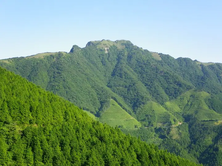
Mt. Kanpū (1,763 m) rises on the border between Saijō City (Ehime) and Ino Town (Kōchi) along the Ishizuchi mountain range in western Shikoku. It lies within Ishizuchi Quasi-National Park and forms part of the Sasagamine Natural Environment Conservation Area designated in 1982. The northeast summit offers a 360-degree panorama spanning the Ishizuchi peaks, the Seto Inland Sea, and the Pacific Ocean. The standard year-round route begins at the south portal of the old Kanpū Tunnel, and the peak is counted among the 100 Famous Mountains of Shikoku and Japan's 1000 Mountains.
Mt. Kanpū at a glance
- Weather: The most settled day in the next 7 days is Wed, November 4: cloudy, gusts up to 5 m/s.
- Route: The shortest is Kanpūzan and Sasagamine Circuit from the Old Kanpūzan Tunnel South Portal: about 6 h 7 min, 10.4 km, about 1,020 m of climbing.
Mt. Kanpū weather (hourly, 14 days)
Sunrise today 06:27, sunset 17:14
| Tue, 11/3 | Wed, 11/4 | Thu, 11/5 | Fri, 11/6 | Sat, 11/7 | Sun, 11/8 | Mon, 11/9 | Tue, 11/10 | Wed, 11/11 | Thu, 11/12 | Fri, 11/13 | Sat, 11/14 | Sun, 11/15 | Mon, 11/16 | Tue, 11/17 | |||||||||||||||||||||||||||||||||||||||||||||||||||||||||||||||||||||||
|---|---|---|---|---|---|---|---|---|---|---|---|---|---|---|---|---|---|---|---|---|---|---|---|---|---|---|---|---|---|---|---|---|---|---|---|---|---|---|---|---|---|---|---|---|---|---|---|---|---|---|---|---|---|---|---|---|---|---|---|---|---|---|---|---|---|---|---|---|---|---|---|---|---|---|---|---|---|---|---|---|---|---|---|---|---|
| Japan time | 15 | 17 | 19 | 21 | 23 | 1 | 3 | 5 | 7 | 9 | 11 | 13 | 15 | 18 | 21 | 0 | 3 | 6 | 9 | 12 | 15 | 18 | 21 | 0 | 3 | 6 | 9 | 12 | 15 | 18 | 21 | 0 | 3 | 6 | 9 | 12 | 15 | 18 | 21 | 0 | 3 | 6 | 9 | 12 | 15 | 18 | 21 | 0 | 3 | 6 | 9 | 15 | 21 | 3 | 9 | 15 | 21 | 3 | 9 | 15 | 21 | 3 | 9 | 15 | 21 | 3 | 9 | 15 | 21 | 3 | 9 | 15 | 21 | 3 | 9 | 15 | 21 | 3 | 9 | 15 | 21 | 3 | 9 | 15 | |
  | |   |   |   | | | |   | | | | | |   | | |   |   |   |   | | | | | | | |  |  | | | | | | | | | | | | | | | | | | | | | | | | | | | | | | | | | | | | | | |  | | | | | |   | | | | | | | | | | ||
| Temperature | °C | 8° | 5° | 4° | 3° | 3° | 3° | 3° | 2° | 2° | 5° | 6° | 7° | 8° | 5° | 5° | 6° | 6° | 7° | 8° | 13° | 11° | 9° | 9° | 9° | 7° | 6° | 6° | 9° | 8° | 2° | 0° | -1° | 0° | -1° | 1° | 3° | 3° | -1° | -2° | -3° | -3° | -3° | 3° | 6° | 5° | 2° | 2° | 1° | 2° | 2° | 5° | 6° | 1° | -3° | 3° | 5° | -1° | -2° | -1° | 2° | -1° | -1° | 2° | 5° | -1° | -1° | 2° | 4° | -1° | -3° | 4° | 7° | 1° | 1° | 6° | 7° | 6° | 7° | 6° | 7° | 2° | -1° | 1° | 4° |
| Precipitation | mm | 0.2 | 0.4 | 0.3 | 1.6 | 0.7 | 1.0 | 0.1 | 0.3 | 0.8 | 2.0 | 0.4 | 0.2 | 0.2 | 0.9 | 1.2 | 0.5 | 0.6 | 0.2 | 1.7 | 4.7 | 0.1 | 0.9 | 1.4 | 2.8 | 0.2 | |||||||||||||||||||||||||||||||||||||||||||||||||||||||||||
| New snow | cm | ||||||||||||||||||||||||||||||||||||||||||||||||||||||||||||||||||||||||||||||||||||
| Snow depth | cm | 0 | 0 | 0 | 0 | 0 | 0 | 0 | 0 | 0 | 0 | 0 | 0 | 0 | 0 | 0 | 0 | 0 | 0 | 0 | 0 | 0 | 0 | 0 | 0 | 0 | 0 | 0 | 0 | 0 | 0 | 0 | 0 | 0 | 0 | 0 | 0 | 0 | 0 | 0 | 0 | 0 | 0 | 0 | 0 | 0 | 0 | 0 | 0 | 0 | 0 | 0 | 0 | 0 | 0 | 0 | 0 | 0 | 0 | 0 | 0 | 0 | 0 | 0 | 0 | 0 | 0 | 0 | 0 | 0 | 0 | 0 | 0 | 0 | 0 | 0 | 0 | 0 | 0 | 0 | 0 | 0 | 0 | 0 | 0 |
| Wind | m/s | 1 | 1 | 0 | 0 | 1 | 1 | 0 | 1 | 1 | 1 | 1 | 1 | 1 | 0 | 0 | 1 | 0 | 0 | 0 | 1 | 1 | 1 | 1 | 3 | 3 | 2 | 3 | 4 | 4 | 2 | 2 | 2 | 3 | 3 | 4 | 3 | 2 | 1 | 0 | 0 | 0 | 1 | 1 | 2 | 2 | 0 | 1 | 1 | 1 | 0 | 1 | 3 | 0 | 0 | 1 | 4 | 2 | 4 | 3 | 2 | 1 | 1 | 1 | 2 | 1 | 0 | 2 | 3 | 0 | 0 | 1 | 1 | 2 | 2 | 2 | 2 | 2 | 1 | 2 | 4 | 3 | 0 | 1 | 2 |
| Wind gusts | m/s | 7 | 4 | 2 | 2 | 2 | 4 | 4 | 4 | 4 | 4 | 5 | 4 | 4 | 4 | 4 | 6 | 5 | 3 | 4 | 4 | 5 | 7 | 7 | 13 | 12 | 10 | 12 | 14 | 14 | 13 | 11 | 10 | 12 | 12 | 12 | 12 | 11 | 8 | 5 | 4 | 2 | 2 | 4 | 6 | 7 | 6 | 3 | 4 | 5 | 4 | 5 | 8 | 7 | 4 | 5 | 11 | 11 | 14 | 14 | 11 | 7 | 3 | 4 | 6 | 6 | 5 | 6 | 9 | 8 | 4 | 4 | 5 | 5 | 7 | 9 | 11 | 12 | 10 | 9 | 12 | 12 | 9 | 4 | 7 |
| Wind dir. | ↓ | ↓ | ↓ | ↓ | ↓ | ↓ | ↓ | ↓ | ↓ | ↓ | ↓ | ↓ | ↓ | ↓ | ↓ | ↓ | ↓ | ↓ | ↓ | ↓ | ↓ | ↓ | ↓ | ↓ | ↓ | ↓ | ↓ | ↓ | ↓ | ↓ | ↓ | ↓ | ↓ | ↓ | ↓ | ↓ | ↓ | ↓ | ↓ | ↓ | ↓ | ↓ | ↓ | ↓ | ↓ | ↓ | ↓ | ↓ | ↓ | ↓ | ↓ | ↓ | ↓ | ↓ | ↓ | ↓ | ↓ | ↓ | ↓ | ↓ | ↓ | ↓ | ↓ | ↓ | ↓ | ↓ | ↓ | ↓ | ↓ | ↓ | ↓ | ↓ | ↓ | ↓ | ↓ | ↓ | ↓ | ↓ | ↓ | ↓ | ↓ | ↓ | ↓ | ↓ | |
Mt. Kanpū hiking routes
Hiking times are estimates calculated from the terrain.
Huts, campsites and lodging near Mt. Kanpū
Mountain huts
Lists that include Mt. Kanpū
Mt. Kanpū facts
- Elevation
- 1,763 m
- Location
- Ino, Kochi / Saijo, Ehime
33.811677, 133.261789 - Website
- ishizuchisankei.com
- Trail Map
- kochi-tabi.jp
- Wikipedia
- ja.wikipedia.org