
Mount Hanamagari
鼻曲山
Karuizawa, Nagano · Elevation 1,655 m
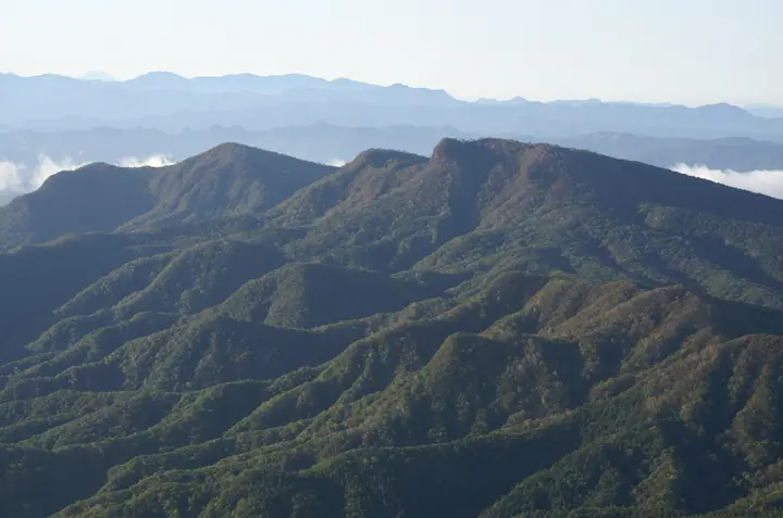
Mount Hanamagari is a 1,655 m peak at the convergence of Takasaki City and Naganohara Town in Gunma and Karuizawa Town in Nagano, set as a forward outpost of the Asama volcanic chain and ridged with neighbouring peaks such as Asamakakushi and Hizuma. Its sharply hooked silhouette — said to resemble a bent nose — gives the mountain its name, and from near the summit climbers gaze across Asama, Myōgi, Jōshū-Hotaka, and as far as the Northern Alps. Multiple trails serve the peak: the Otome route from Kunizakai-daira and Naga-Hyuga on the Karuizawa side, a route via Hizuma from Nidoage Pass, and the line from Annaka's Kyū-Usui Pass via Mount Tomeo. The mountain features in Kantō Hyakumeizan, Shinshū Hyakumeizan, and Gunma Hyakumeizan.
Mount Hanamagari at a glance
- Weather: The most settled day in the next 7 days is Sun, November 8: clear, gusts up to 6 m/s.
Mount Hanamagari weather (hourly, 14 days)
Sunrise today 06:10, sunset 16:48
| Tue, 11/3 | Wed, 11/4 | Thu, 11/5 | Fri, 11/6 | Sat, 11/7 | Sun, 11/8 | Mon, 11/9 | Tue, 11/10 | Wed, 11/11 | Thu, 11/12 | Fri, 11/13 | Sat, 11/14 | Sun, 11/15 | Mon, 11/16 | Tue, 11/17 | |||||||||||||||||||||||||||||||||||||||||||||||||||||||||||||||||||||||
|---|---|---|---|---|---|---|---|---|---|---|---|---|---|---|---|---|---|---|---|---|---|---|---|---|---|---|---|---|---|---|---|---|---|---|---|---|---|---|---|---|---|---|---|---|---|---|---|---|---|---|---|---|---|---|---|---|---|---|---|---|---|---|---|---|---|---|---|---|---|---|---|---|---|---|---|---|---|---|---|---|---|---|---|---|---|
| Japan time | 15 | 17 | 19 | 21 | 23 | 1 | 3 | 5 | 7 | 9 | 11 | 13 | 15 | 18 | 21 | 0 | 3 | 6 | 9 | 12 | 15 | 18 | 21 | 0 | 3 | 6 | 9 | 12 | 15 | 18 | 21 | 0 | 3 | 6 | 9 | 12 | 15 | 18 | 21 | 0 | 3 | 6 | 9 | 12 | 15 | 18 | 21 | 0 | 3 | 6 | 9 | 15 | 21 | 3 | 9 | 15 | 21 | 3 | 9 | 15 | 21 | 3 | 9 | 15 | 21 | 3 | 9 | 15 | 21 | 3 | 9 | 15 | 21 | 3 | 9 | 15 | 21 | 3 | 9 | 15 | 21 | 3 | 9 | 15 | |
  |   |   | | | | | |   | |  | | |   |   | | |   |   | | | | | | |   | | | |  | | | | | | | | | | | | | | | | | | | | | |   | | |   |   | | |   |   | | | | | | | | | |  | | | | | | | | | | | | | | | ||
| Temperature | °C | 9° | 4° | 2° | 0° | -1° | 0° | 0° | 0° | 1° | 6° | 8° | 8° | 6° | 3° | 3° | 3° | 4° | 4° | 7° | 10° | 10° | 7° | 7° | 6° | 5° | 5° | 12° | 15° | 14° | 6° | 4° | 3° | 2° | 2° | 5° | 6° | 4° | 0° | -1° | -2° | -2° | -2° | 4° | 8° | 6° | 2° | 1° | 1° | 1° | 1° | 4° | 4° | 2° | 1° | 1° | 3° | 1° | 0° | 1° | 2° | 0° | -3° | 3° | 5° | -1° | -1° | 4° | 3° | -4° | -4° | 4° | 5° | -2° | -2° | 5° | 9° | 4° | 4° | 11° | 8° | 1° | -2° | 3° | 4° |
| Precipitation | mm | 0.3 | 1.1 | 10 | 4.2 | 2.0 | 0.4 | 0.2 | 0.4 | 1.4 | 0.2 | 0.1 | 0.6 | 1.4 | 1.1 | 0.7 | 0.2 | 6 | 7 | 0.2 | |||||||||||||||||||||||||||||||||||||||||||||||||||||||||||||||||
| New snow | cm | <.1 | 0.7 | 0.2 | |||||||||||||||||||||||||||||||||||||||||||||||||||||||||||||||||||||||||||||||||
| Snow depth | cm | 0 | 0 | 0 | 0 | 0 | 0 | 0 | 0 | 0 | 0 | 0 | 0 | 0 | 0 | 0 | 0 | 0 | 0 | 0 | 0 | 0 | 0 | 0 | 0 | 0 | 0 | 0 | 0 | 0 | 0 | 0 | 0 | 0 | 0 | 0 | 0 | 0 | 0 | 0 | 0 | 0 | 0 | 0 | 0 | 0 | 0 | 0 | 0 | 0 | 0 | 0 | 0 | 0 | 0 | 0 | 0 | 0 | 0 | <1 | <1 | 0 | 0 | 0 | 0 | 0 | 0 | 0 | 0 | 0 | 0 | 0 | 0 | 0 | 0 | 0 | 0 | 0 | 0 | 0 | 0 | 0 | 0 | 0 | 0 |
| Wind | m/s | 1 | 0 | 1 | 2 | 2 | 1 | 1 | 1 | 1 | 2 | 2 | 3 | 2 | 2 | 1 | 1 | 1 | 1 | 1 | 1 | 1 | 0 | 1 | 1 | 1 | 2 | 1 | 3 | 2 | 1 | 2 | 2 | 2 | 2 | 3 | 5 | 4 | 3 | 3 | 3 | 3 | 2 | 2 | 1 | 1 | 0 | 2 | 0 | 1 | 1 | 1 | 1 | 1 | 1 | 1 | 2 | 1 | 3 | 5 | 3 | 2 | 2 | 1 | 3 | 1 | 2 | 2 | 3 | 2 | 2 | 1 | 2 | 1 | 0 | 0 | 1 | 1 | 1 | 1 | 5 | 2 | 2 | 1 | 2 |
| Wind gusts | m/s | 6 | 5 | 4 | 5 | 5 | 5 | 4 | 4 | 3 | 5 | 7 | 8 | 8 | 6 | 5 | 3 | 3 | 3 | 3 | 5 | 3 | 3 | 3 | 4 | 5 | 5 | 5 | 9 | 9 | 7 | 5 | 7 | 7 | 7 | 10 | 14 | 14 | 10 | 8 | 8 | 7 | 7 | 6 | 6 | 5 | 4 | 4 | 5 | 4 | 4 | 4 | 6 | 4 | 4 | 4 | 7 | 6 | 7 | 22 | 16 | 9 | 5 | 6 | 9 | 8 | 5 | 6 | 10 | 8 | 6 | 5 | 7 | 5 | 3 | 3 | 5 | 4 | 4 | 5 | 12 | 12 | 6 | 5 | 7 |
| Wind dir. | ↓ | ↓ | ↓ | ↓ | ↓ | ↓ | ↓ | ↓ | ↓ | ↓ | ↓ | ↓ | ↓ | ↓ | ↓ | ↓ | ↓ | ↓ | ↓ | ↓ | ↓ | ↓ | ↓ | ↓ | ↓ | ↓ | ↓ | ↓ | ↓ | ↓ | ↓ | ↓ | ↓ | ↓ | ↓ | ↓ | ↓ | ↓ | ↓ | ↓ | ↓ | ↓ | ↓ | ↓ | ↓ | ↓ | ↓ | ↓ | ↓ | ↓ | ↓ | ↓ | ↓ | ↓ | ↓ | ↓ | ↓ | ↓ | ↓ | ↓ | ↓ | ↓ | ↓ | ↓ | ↓ | ↓ | ↓ | ↓ | ↓ | ↓ | ↓ | ↓ | ↓ | ↓ | ↓ | ↓ | ↓ | ↓ | ↓ | ↓ | ↓ | ↓ | ↓ | ↓ | |
Huts, campsites and lodging near Mount Hanamagari
Campsites
- Rising Field Karuizawa
Lodging
- 倉渕川浦温泉 はまゆう山荘
Lists that include Mount Hanamagari
100 Famous Hot Spring Mountains · Kanto 100 Famous Mountains · Shinshu 100 Famous Mountains · Gunma 100 Famous Mountains · Elevations of 1003 Mountains of Japan · 1000 Mountains of Japan
Mount Hanamagari facts
- Also known as
- 小天狗
- Elevation
- 1,655 m
- Location
- Karuizawa, Nagano
36.410857, 138.645342 - Website
- www.town.karuizawa.lg.jp
- Trail Map
- karuizawa-kankokyokai.jp (PDF)
- Wikipedia
- ja.wikipedia.org