
Mount Asamakakushi
浅間隠山
Naganohara, Gunma · Elevation 1,757 m
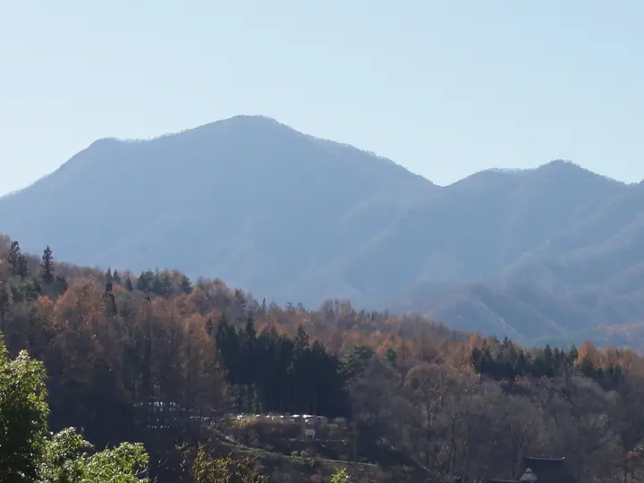
Mount Asamakakushi is a 1,756.7 m conical peak on the border between Higashi-Agatsuma and Naganohara towns in Agatsuma District, Gunma Prefecture. The name—"the peak that hides Asama"—reflects how it obscures Mount Asama to the west when viewed from Nakanojō and Higashi-Agatsuma; alternative names include Kawaura-Fuji, for its Fuji-like profile, and Yahazu-yama, for its twin summit. It is included in the Nihon Nihyaku Meizan, the Gunma Hyakumeizan, and the Kantō Hyakumeizan. The summit offers a 360° panorama of Mount Asama, the Northern Alps, the Jōshin'etsu mountains, and the distant Kantō Plain. Three main trails climb the peak: the short Nidoagari Pass route (3–4 hours round trip), the line from Asamakakushi Onsen on the Higashi-Agatsuma side, and the route via Warabi-daira Campground. Rhododendron stands at the summit are protected by a rope barrier with restricted entry.
Mount Asamakakushi at a glance
- Weather: The most settled day in the next 7 days is Sun, November 8: clear, gusts up to 6 m/s.
- Route: The shortest is Mount Asamakakushi from Nidoage Pass: about 2 h 55 min, 4.5 km, about 470 m of climbing.
Mount Asamakakushi weather (hourly, 14 days)
Sunrise today 06:10, sunset 16:48
| Tue, 11/3 | Wed, 11/4 | Thu, 11/5 | Fri, 11/6 | Sat, 11/7 | Sun, 11/8 | Mon, 11/9 | Tue, 11/10 | Wed, 11/11 | Thu, 11/12 | Fri, 11/13 | Sat, 11/14 | Sun, 11/15 | Mon, 11/16 | Tue, 11/17 | |||||||||||||||||||||||||||||||||||||||||||||||||||||||||||||||||||||||
|---|---|---|---|---|---|---|---|---|---|---|---|---|---|---|---|---|---|---|---|---|---|---|---|---|---|---|---|---|---|---|---|---|---|---|---|---|---|---|---|---|---|---|---|---|---|---|---|---|---|---|---|---|---|---|---|---|---|---|---|---|---|---|---|---|---|---|---|---|---|---|---|---|---|---|---|---|---|---|---|---|---|---|---|---|---|
| Japan time | 15 | 17 | 19 | 21 | 23 | 1 | 3 | 5 | 7 | 9 | 11 | 13 | 15 | 18 | 21 | 0 | 3 | 6 | 9 | 12 | 15 | 18 | 21 | 0 | 3 | 6 | 9 | 12 | 15 | 18 | 21 | 0 | 3 | 6 | 9 | 12 | 15 | 18 | 21 | 0 | 3 | 6 | 9 | 12 | 15 | 18 | 21 | 0 | 3 | 6 | 9 | 15 | 21 | 3 | 9 | 15 | 21 | 3 | 9 | 15 | 21 | 3 | 9 | 15 | 21 | 3 | 9 | 15 | 21 | 3 | 9 | 15 | 21 | 3 | 9 | 15 | 21 | 3 | 9 | 15 | 21 | 3 | 9 | 15 | |
  |   |   | | | | | |   | |  | | |   |   | | |   |   | | | | | | |   | | | |  | | | | | | | | | | | | | | | | | | | | | |   | | |   |   | | |   |   | | | | | | | | | |  | | | | | | | | | | | | | | | ||
| Temperature | °C | 9° | 4° | 1° | -1° | -2° | -1° | 0° | -1° | 1° | 6° | 7° | 7° | 5° | 2° | 2° | 2° | 3° | 4° | 7° | 10° | 9° | 6° | 6° | 5° | 5° | 5° | 12° | 15° | 14° | 5° | 3° | 2° | 1° | 1° | 4° | 5° | 4° | 0° | -2° | -2° | -2° | -2° | 3° | 7° | 6° | 1° | 0° | 0° | 1° | 1° | 3° | 4° | 1° | 0° | 0° | 2° | 0° | 0° | 0° | 1° | -1° | -4° | 3° | 4° | -2° | -2° | 4° | 2° | -4° | -5° | 3° | 4° | -2° | -2° | 4° | 8° | 3° | 4° | 10° | 7° | 1° | -3° | 2° | 3° |
| Precipitation | mm | 0.3 | 1.1 | 10 | 4.2 | 2.0 | 0.4 | 0.2 | 0.4 | 1.4 | 0.2 | 0.1 | 0.6 | 1.4 | 1.1 | 0.7 | 0.2 | 6 | 7 | 0.2 | |||||||||||||||||||||||||||||||||||||||||||||||||||||||||||||||||
| New snow | cm | <.1 | 0.7 | 0.2 | |||||||||||||||||||||||||||||||||||||||||||||||||||||||||||||||||||||||||||||||||
| Snow depth | cm | 0 | 0 | 0 | 0 | 0 | 0 | 0 | 0 | 0 | 0 | 0 | 0 | 0 | 0 | 0 | 0 | 0 | 0 | 0 | 0 | 0 | 0 | 0 | 0 | 0 | 0 | 0 | 0 | 0 | 0 | 0 | 0 | 0 | 0 | 0 | 0 | 0 | 0 | 0 | 0 | 0 | 0 | 0 | 0 | 0 | 0 | 0 | 0 | 0 | 0 | 0 | 0 | 0 | 0 | 0 | 0 | 0 | 0 | <1 | <1 | 0 | 0 | 0 | 0 | 0 | 0 | 0 | 0 | 0 | 0 | 0 | 0 | 0 | 0 | 0 | 0 | 0 | 0 | 0 | 0 | 0 | 0 | 0 | 0 |
| Wind | m/s | 1 | 0 | 1 | 2 | 2 | 1 | 1 | 1 | 1 | 2 | 2 | 3 | 2 | 2 | 1 | 1 | 1 | 1 | 1 | 1 | 1 | 0 | 1 | 1 | 1 | 2 | 1 | 3 | 2 | 1 | 2 | 2 | 2 | 2 | 3 | 5 | 4 | 3 | 3 | 3 | 3 | 2 | 2 | 1 | 1 | 0 | 2 | 0 | 1 | 1 | 1 | 1 | 1 | 1 | 1 | 2 | 1 | 3 | 5 | 3 | 2 | 2 | 1 | 3 | 1 | 2 | 2 | 3 | 2 | 2 | 1 | 2 | 1 | 0 | 0 | 1 | 1 | 1 | 1 | 5 | 2 | 2 | 1 | 2 |
| Wind gusts | m/s | 6 | 5 | 4 | 5 | 5 | 5 | 4 | 4 | 3 | 5 | 7 | 8 | 8 | 6 | 5 | 3 | 3 | 3 | 3 | 5 | 3 | 3 | 3 | 4 | 5 | 5 | 5 | 9 | 9 | 7 | 5 | 7 | 7 | 7 | 10 | 14 | 14 | 10 | 8 | 8 | 7 | 7 | 6 | 6 | 5 | 4 | 4 | 5 | 4 | 4 | 4 | 6 | 4 | 4 | 4 | 7 | 6 | 7 | 22 | 16 | 9 | 5 | 6 | 9 | 8 | 5 | 6 | 10 | 8 | 6 | 5 | 7 | 5 | 3 | 3 | 5 | 4 | 4 | 5 | 12 | 12 | 6 | 5 | 7 |
| Wind dir. | ↓ | ↓ | ↓ | ↓ | ↓ | ↓ | ↓ | ↓ | ↓ | ↓ | ↓ | ↓ | ↓ | ↓ | ↓ | ↓ | ↓ | ↓ | ↓ | ↓ | ↓ | ↓ | ↓ | ↓ | ↓ | ↓ | ↓ | ↓ | ↓ | ↓ | ↓ | ↓ | ↓ | ↓ | ↓ | ↓ | ↓ | ↓ | ↓ | ↓ | ↓ | ↓ | ↓ | ↓ | ↓ | ↓ | ↓ | ↓ | ↓ | ↓ | ↓ | ↓ | ↓ | ↓ | ↓ | ↓ | ↓ | ↓ | ↓ | ↓ | ↓ | ↓ | ↓ | ↓ | ↓ | ↓ | ↓ | ↓ | ↓ | ↓ | ↓ | ↓ | ↓ | ↓ | ↓ | ↓ | ↓ | ↓ | ↓ | ↓ | ↓ | ↓ | ↓ | ↓ | |
Mount Asamakakushi hiking routes
Hiking times are estimates calculated from the terrain.
Huts, campsites and lodging near Mount Asamakakushi
Campsites
- わらび平森林公園キャンプ場
Lodging
- 倉渕川浦温泉 はまゆう山荘
Lists that include Mount Asamakakushi
Japan 200 Famous Mountains · Japan's 300 Famous Mountains · Kanto 100 Famous Mountains · Gunma 100 Famous Mountains · Elevations of 1003 Mountains of Japan · 1000 Mountains of Japan
Mount Asamakakushi facts
- Also known as
- 川浦富士 · 矢筈山
- Elevation
- 1,757 m
- Location
- Naganohara, Gunma
36.453693, 138.652493 - Trail Map
- www.town.higashiagatsuma.gunma.jp (PDF)
- Wikipedia
- ja.wikipedia.org