
Mount Asamakakushi
浅間隠山
นางาโนฮาระ, กุมมะ · ความสูง 1,757 ม.
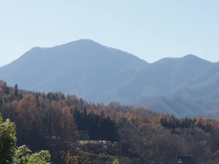
Mount Asamakakushi is a 1,756.7 m conical peak on the border between Higashi-Agatsuma and Naganohara towns in Agatsuma District, Gunma Prefecture. The name—"the peak that hides Asama"—reflects how it obscures Mount Asama to the west when viewed from Nakanojō and Higashi-Agatsuma; alternative names include Kawaura-Fuji, for its Fuji-like profile, and Yahazu-yama, for its twin summit. It is included in the Nihon Nihyaku Meizan, the Gunma Hyakumeizan, and the Kantō Hyakumeizan. The summit offers a 360° panorama of Mount Asama, the Northern Alps, the Jōshin'etsu mountains, and the distant Kantō Plain. Three main trails climb the peak: the short Nidoagari Pass route (3–4 hours round trip), the line from Asamakakushi Onsen on the Higashi-Agatsuma side, and the route via Warabi-daira Campground. Rhododendron stands at the summit are protected by a rope barrier with restricted entry.
สรุป Mount Asamakakushi
- อากาศ: วันที่อากาศคงที่ที่สุดใน 7 วันข้างหน้าคือ อาทิตย์ 8 พฤศจิกายน: ท้องฟ้าแจ่มใส ลมกระโชกสูงสุด 6 ม./วินาที
- เส้นทาง: เส้นทางที่สั้นที่สุดคือ Mount Asamakakushi from Nidoage Pass: ประมาณ 2 ชม. 55 นาที 4.5 km ขึ้นประมาณ 470 m
อากาศ Mount Asamakakushi (รายชั่วโมง 2 สัปดาห์)
วันนี้พระอาทิตย์ขึ้น 06:10 ตก 16:48
| อังคาร 3/11 | พุธ 4/11 | พฤหัส 5/11 | ศุกร์ 6/11 | เสาร์ 7/11 | อาทิตย์ 8/11 | จันทร์ 9/11 | อังคาร 10/11 | พุธ 11/11 | พฤหัส 12/11 | ศุกร์ 13/11 | เสาร์ 14/11 | อาทิตย์ 15/11 | จันทร์ 16/11 | อังคาร 17/11 | |||||||||||||||||||||||||||||||||||||||||||||||||||||||||||||||||||||||
|---|---|---|---|---|---|---|---|---|---|---|---|---|---|---|---|---|---|---|---|---|---|---|---|---|---|---|---|---|---|---|---|---|---|---|---|---|---|---|---|---|---|---|---|---|---|---|---|---|---|---|---|---|---|---|---|---|---|---|---|---|---|---|---|---|---|---|---|---|---|---|---|---|---|---|---|---|---|---|---|---|---|---|---|---|---|
| เวลาญี่ปุ่น | 15 | 17 | 19 | 21 | 23 | 1 | 3 | 5 | 7 | 9 | 11 | 13 | 15 | 18 | 21 | 0 | 3 | 6 | 9 | 12 | 15 | 18 | 21 | 0 | 3 | 6 | 9 | 12 | 15 | 18 | 21 | 0 | 3 | 6 | 9 | 12 | 15 | 18 | 21 | 0 | 3 | 6 | 9 | 12 | 15 | 18 | 21 | 0 | 3 | 6 | 9 | 15 | 21 | 3 | 9 | 15 | 21 | 3 | 9 | 15 | 21 | 3 | 9 | 15 | 21 | 3 | 9 | 15 | 21 | 3 | 9 | 15 | 21 | 3 | 9 | 15 | 21 | 3 | 9 | 15 | 21 | 3 | 9 | 15 | |
  |   |   | | | | | |   | |  | | |   |   | | |   |   | | | | | | |   | | | |  | | | | | | | | | | | | | | | | | | | | | |   | | |   |   | | |   |   | | | | | | | | | |  | | | | | | | | | | | | | | | ||
| อุณหภูมิ | °C | 9° | 4° | 1° | -1° | -2° | -1° | 0° | -1° | 1° | 6° | 7° | 7° | 5° | 2° | 2° | 2° | 3° | 4° | 7° | 10° | 9° | 6° | 6° | 5° | 5° | 5° | 12° | 15° | 14° | 5° | 3° | 2° | 1° | 1° | 4° | 5° | 4° | 0° | -2° | -2° | -2° | -2° | 3° | 7° | 6° | 1° | 0° | 0° | 1° | 1° | 3° | 4° | 1° | 0° | 0° | 2° | 0° | 0° | 0° | 1° | -1° | -4° | 3° | 4° | -2° | -2° | 4° | 2° | -4° | -5° | 3° | 4° | -2° | -2° | 4° | 8° | 3° | 4° | 10° | 7° | 1° | -3° | 2° | 3° |
| ฝนและหิมะ | mm | 0.3 | 1.1 | 10 | 4.2 | 2.0 | 0.4 | 0.2 | 0.4 | 1.4 | 0.2 | 0.1 | 0.6 | 1.4 | 1.1 | 0.7 | 0.2 | 6 | 7 | 0.2 | |||||||||||||||||||||||||||||||||||||||||||||||||||||||||||||||||
| หิมะตก | cm | <.1 | 0.7 | 0.2 | |||||||||||||||||||||||||||||||||||||||||||||||||||||||||||||||||||||||||||||||||
| หิมะสะสม | cm | 0 | 0 | 0 | 0 | 0 | 0 | 0 | 0 | 0 | 0 | 0 | 0 | 0 | 0 | 0 | 0 | 0 | 0 | 0 | 0 | 0 | 0 | 0 | 0 | 0 | 0 | 0 | 0 | 0 | 0 | 0 | 0 | 0 | 0 | 0 | 0 | 0 | 0 | 0 | 0 | 0 | 0 | 0 | 0 | 0 | 0 | 0 | 0 | 0 | 0 | 0 | 0 | 0 | 0 | 0 | 0 | 0 | 0 | <1 | <1 | 0 | 0 | 0 | 0 | 0 | 0 | 0 | 0 | 0 | 0 | 0 | 0 | 0 | 0 | 0 | 0 | 0 | 0 | 0 | 0 | 0 | 0 | 0 | 0 |
| ลม | m/s | 1 | 0 | 1 | 2 | 2 | 1 | 1 | 1 | 1 | 2 | 2 | 3 | 2 | 2 | 1 | 1 | 1 | 1 | 1 | 1 | 1 | 0 | 1 | 1 | 1 | 2 | 1 | 3 | 2 | 1 | 2 | 2 | 2 | 2 | 3 | 5 | 4 | 3 | 3 | 3 | 3 | 2 | 2 | 1 | 1 | 0 | 2 | 0 | 1 | 1 | 1 | 1 | 1 | 1 | 1 | 2 | 1 | 3 | 5 | 3 | 2 | 2 | 1 | 3 | 1 | 2 | 2 | 3 | 2 | 2 | 1 | 2 | 1 | 0 | 0 | 1 | 1 | 1 | 1 | 5 | 2 | 2 | 1 | 2 |
| ลมกระโชก | m/s | 6 | 5 | 4 | 5 | 5 | 5 | 4 | 4 | 3 | 5 | 7 | 8 | 8 | 6 | 5 | 3 | 3 | 3 | 3 | 5 | 3 | 3 | 3 | 4 | 5 | 5 | 5 | 9 | 9 | 7 | 5 | 7 | 7 | 7 | 10 | 14 | 14 | 10 | 8 | 8 | 7 | 7 | 6 | 6 | 5 | 4 | 4 | 5 | 4 | 4 | 4 | 6 | 4 | 4 | 4 | 7 | 6 | 7 | 22 | 16 | 9 | 5 | 6 | 9 | 8 | 5 | 6 | 10 | 8 | 6 | 5 | 7 | 5 | 3 | 3 | 5 | 4 | 4 | 5 | 12 | 12 | 6 | 5 | 7 |
| ทิศทางลม | ↓ | ↓ | ↓ | ↓ | ↓ | ↓ | ↓ | ↓ | ↓ | ↓ | ↓ | ↓ | ↓ | ↓ | ↓ | ↓ | ↓ | ↓ | ↓ | ↓ | ↓ | ↓ | ↓ | ↓ | ↓ | ↓ | ↓ | ↓ | ↓ | ↓ | ↓ | ↓ | ↓ | ↓ | ↓ | ↓ | ↓ | ↓ | ↓ | ↓ | ↓ | ↓ | ↓ | ↓ | ↓ | ↓ | ↓ | ↓ | ↓ | ↓ | ↓ | ↓ | ↓ | ↓ | ↓ | ↓ | ↓ | ↓ | ↓ | ↓ | ↓ | ↓ | ↓ | ↓ | ↓ | ↓ | ↓ | ↓ | ↓ | ↓ | ↓ | ↓ | ↓ | ↓ | ↓ | ↓ | ↓ | ↓ | ↓ | ↓ | ↓ | ↓ | ↓ | ↓ | |
เส้นทางเดินป่า Mount Asamakakushi
เวลาเดินเป็นค่าประมาณที่คำนวณจากภูมิประเทศ
กระท่อม ที่ตั้งแคมป์ และที่พักใกล้ Mount Asamakakushi
ที่ตั้งแคมป์
- わらび平森林公園キャンプ場
ที่พัก
- 倉渕川浦温泉 はまゆう山荘
รายชื่อที่มี Mount Asamakakushi
200 ภูเขาที่มีชื่อเสียงของญี่ปุ่น · 300 ภูเขาที่มีชื่อเสียงของญี่ปุ่น · 100 ภูเขาที่มีชื่อเสียงของคันโต · 100 ภูเขาที่มีชื่อเสียงของกุมมะ · ระดับความสูงของภูเขา 1003 แห่งในญี่ปุ่น · ภูเขา 1000 แห่งของญี่ปุ่น
ข้อมูลพื้นฐาน Mount Asamakakushi
- ชื่ออื่น
- 川浦富士 · 矢筈山
- ความสูง
- 1,757 ม.
- ที่ตั้ง
- นางาโนฮาระ, กุมมะ
36.453693, 138.652493 - เว็บไซต์
- www.town.higashiagatsuma.gunma.jp
- แผนที่เส้นทางเดินเขา
- www.town.higashiagatsuma.gunma.jp (PDF)
- วิกิพีเดีย
- ja.wikipedia.org