
Mount Gassan
月山
Shōnai-machi, Yamagata · Elevation 1,984 m
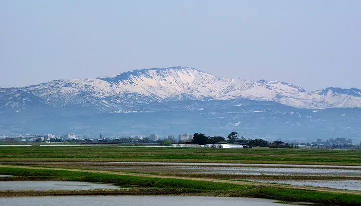
Mount Gassan is a 1,984 m sacred peak enshrining Tsukuyomi-no-Mikoto and one of the Dewa Sanzan together with Mount Haguro and Mount Yudono. Located within Bandai-Asahi National Park, it has long been a center of Shugendō mountain worship, symbolizing the present world in the trinity's past–present–future framework. Listed in the Hyakumeizan and the 100 Mountains of Flowers, the alpine plateau at Midagahara is famous for summer wildflowers. The Gassan Shrine main hall on the summit is open to pilgrims from July 1 through September 15 each year, with a roughly three-hour climb from the eighth-station trailhead.
Mount Gassan at a glance
- Weather: The most settled day in the next 7 days is Mon, November 9: cloudy, gusts up to 9 m/s. Fri, Nov 6, Sat, Nov 7, Sun, Nov 8: strong wind (gusts up to 26 m/s).
- Route: The shortest is Mount Uba and Mount Gassan Loop from Gassan Lift Upper Station: about 4 h 4 min, 6.5 km, about 580 m of climbing.
Mount Gassan weather (hourly, 14 days)
Sunrise today 06:08, sunset 16:39
| Tue, 11/3 | Wed, 11/4 | Thu, 11/5 | Fri, 11/6 | Sat, 11/7 | Sun, 11/8 | Mon, 11/9 | Tue, 11/10 | Wed, 11/11 | Thu, 11/12 | Fri, 11/13 | Sat, 11/14 | Sun, 11/15 | Mon, 11/16 | Tue, 11/17 | |||||||||||||||||||||||||||||||||||||||||||||||||||||||||||||||||||||||
|---|---|---|---|---|---|---|---|---|---|---|---|---|---|---|---|---|---|---|---|---|---|---|---|---|---|---|---|---|---|---|---|---|---|---|---|---|---|---|---|---|---|---|---|---|---|---|---|---|---|---|---|---|---|---|---|---|---|---|---|---|---|---|---|---|---|---|---|---|---|---|---|---|---|---|---|---|---|---|---|---|---|---|---|---|---|
| Japan time | 15 | 17 | 19 | 21 | 23 | 1 | 3 | 5 | 7 | 9 | 11 | 13 | 15 | 18 | 21 | 0 | 3 | 6 | 9 | 12 | 15 | 18 | 21 | 0 | 3 | 6 | 9 | 12 | 15 | 18 | 21 | 0 | 3 | 6 | 9 | 12 | 15 | 18 | 21 | 0 | 3 | 6 | 9 | 12 | 15 | 18 | 21 | 0 | 3 | 6 | 9 | 15 | 21 | 3 | 9 | 15 | 21 | 3 | 9 | 15 | 21 | 3 | 9 | 15 | 21 | 3 | 9 | 15 | 21 | 3 | 9 | 15 | 21 | 3 | 9 | 15 | 21 | 3 | 9 | 15 | 21 | 3 | 9 | 15 | |
  |   | | | | |   | | | |   | | | | | |   |   |   | | |   | | | | | | | | | |   | |   |   | | | | | | | | | | | | | | |   |   |   | | |  | | | |   |   | | | | | | | | | | | | |  | | | | | | | | | | | | ||
| Temperature | °C | 1° | -1° | -2° | -2° | -2° | -2° | -1° | -1° | 0° | 3° | 5° | 5° | 4° | 0° | 0° | 2° | 2° | 3° | 5° | 5° | 6° | 4° | 4° | 5° | 5° | 5° | 6° | 5° | 4° | 2° | -1° | -3° | -4° | -5° | -5° | -4° | -5° | -6° | -6° | -6° | -5° | -5° | -4° | -3° | -4° | -4° | -5° | -6° | -5° | -6° | -3° | -4° | -6° | -7° | -3° | -1° | -4° | -5° | -3° | -2° | -4° | -5° | -2° | -3° | -4° | -2° | -4° | -4° | -5° | -6° | -2° | 0° | -4° | -1° | 4° | 6° | 1° | 1° | 2° | -1° | -6° | -6° | -4° | -3° |
| Precipitation | mm | 0.6 | 4.1 | 6 | 3.1 | 0.5 | 0.7 | 2.2 | 0.1 | 0.2 | 3.4 | 2.5 | 1.8 | 3.9 | 4.4 | 7 | 6 | 7 | 4.6 | 2.7 | 3.0 | 2.1 | 2.6 | 2.8 | 2.7 | 2.3 | 1.4 | 0.7 | 0.8 | 0.4 | 0.2 | 0.3 | 0.6 | 0.3 | 2.8 | 12 | 2.8 | 0.6 | 0.9 | 0.8 | 0.6 | 1.6 | 0.4 | 6 | 2.1 | 1.8 | 0.9 | 2.4 | 7 | 3.8 | 14 | 6 | 0.6 | 0.2 | |||||||||||||||||||||||||||||||
| New snow | cm | <.1 | 3.0 | 5.4 | 4.4 | 2.6 | 2.8 | 2.1 | 2.5 | 2.8 | 2.6 | 2.2 | 1.1 | 0.6 | 0.7 | 0.3 | 0.2 | 0.3 | <.1 | 2.0 | 6.3 | 2.8 | <.1 | <.1 | 1.4 | 0.9 | <.1 | 1.6 | 0.6 | 0.2 | |||||||||||||||||||||||||||||||||||||||||||||||||||||||
| Snow depth | cm | 0 | 0 | 0 | 0 | 0 | 0 | 0 | 0 | 0 | 0 | 0 | 0 | 0 | 0 | 0 | 0 | 0 | 0 | 0 | 0 | 0 | 0 | 0 | 0 | 0 | 0 | 0 | 0 | 0 | 0 | 0 | 0 | 2 | 4 | 7 | 8 | 9 | 10 | 11 | 13 | 14 | 15 | 15 | 14 | 14 | 14 | 13 | 13 | 13 | 13 | 12 | 11 | 10 | 10 | 10 | 8 | 9 | 12 | 14 | 11 | 10 | 9 | 8 | 6 | 5 | 4 | 3 | 3 | 3 | 3 | 3 | 2 | 2 | 2 | 2 | <1 | <1 | 0 | 0 | 0 | <1 | <1 | <1 | <1 |
| Wind | m/s | 5 | 3 | 3 | 2 | 2 | 2 | 2 | 3 | 3 | 3 | 3 | 2 | 2 | 1 | 2 | 3 | 3 | 3 | 1 | 2 | 2 | 1 | 1 | 1 | 2 | 3 | 4 | 6 | 6 | 4 | 5 | 5 | 4 | 3 | 5 | 6 | 6 | 6 | 5 | 5 | 6 | 6 | 7 | 7 | 6 | 4 | 3 | 3 | 2 | 1 | 1 | 2 | 1 | 1 | 1 | 3 | 3 | 2 | 3 | 4 | 2 | 2 | 3 | 2 | 2 | 2 | 5 | 6 | 3 | 2 | 2 | 1 | 0 | 1 | 2 | 2 | 1 | 1 | 2 | 6 | 6 | 3 | 2 | 2 |
| Wind gusts | m/s | 18 | 16 | 11 | 11 | 9 | 10 | 11 | 11 | 11 | 11 | 12 | 9 | 6 | 7 | 10 | 12 | 12 | 12 | 11 | 7 | 10 | 7 | 8 | 10 | 11 | 13 | 18 | 21 | 22 | 21 | 18 | 18 | 18 | 21 | 22 | 26 | 26 | 26 | 23 | 22 | 21 | 21 | 23 | 25 | 24 | 20 | 15 | 12 | 11 | 10 | 7 | 9 | 8 | 7 | 6 | 12 | 16 | 15 | 12 | 17 | 15 | 10 | 11 | 12 | 10 | 13 | 16 | 20 | 19 | 12 | 10 | 8 | 6 | 7 | 9 | 11 | 11 | 11 | 11 | 21 | 23 | 19 | 13 | 8 |
| Wind dir. | ↓ | ↓ | ↓ | ↓ | ↓ | ↓ | ↓ | ↓ | ↓ | ↓ | ↓ | ↓ | ↓ | ↓ | ↓ | ↓ | ↓ | ↓ | ↓ | ↓ | ↓ | ↓ | ↓ | ↓ | ↓ | ↓ | ↓ | ↓ | ↓ | ↓ | ↓ | ↓ | ↓ | ↓ | ↓ | ↓ | ↓ | ↓ | ↓ | ↓ | ↓ | ↓ | ↓ | ↓ | ↓ | ↓ | ↓ | ↓ | ↓ | ↓ | ↓ | ↓ | ↓ | ↓ | ↓ | ↓ | ↓ | ↓ | ↓ | ↓ | ↓ | ↓ | ↓ | ↓ | ↓ | ↓ | ↓ | ↓ | ↓ | ↓ | ↓ | ↓ | ↓ | ↓ | ↓ | ↓ | ↓ | ↓ | ↓ | ↓ | ↓ | ↓ | ↓ | ↓ | |
Mount Gassan hiking routes
- Mount Uba and Mount Gassan Loop from Gassan Lift Upper Station 6.5 km · Ascent 579 m リフト上 (Aerialway station)
- Mount Gassan Return via the Ubasawa Old Trail 10.1 km · Ascent 833 m Ubasawa Parking Lot, Ubasawa (Bus stop)
- Mount Gassan Out-and-Back via the Haguro Eighth Station Route 10.2 km · Ascent 591 m 月山八合目駐車場
Hiking times are estimates calculated from the terrain.
Huts, campsites and lodging near Mount Gassan
Mountain huts
Lists that include Mount Gassan
100 Famous Japanese Mountains · Japan 200 Famous Mountains · Japan's 300 Famous Mountains · 100 Famous Mountains of Flowers · New 100 Famous Flower Mountains · 100 Famous Mountains with First-order Triangulation Points · New Japan 100 Famous Mountains · 100 Famous Hot Spring Mountains · Tohoku 100 Famous Mountains · Yamagata 100 Famous Mountains · Three Mountains of Dewa · Elevations of 1003 Mountains of Japan · 1000 Mountains of Japan
Mount Gassan facts
- Elevation
- 1,984 m
- Location
- Shōnai-machi, Yamagata
38.548694, 140.026835 - National Park
- 磐梯朝日国立公園
- Season Opens
- July 1
- Season Closes
- September 15
- Website
- gassan.jp
- Trail Map
- www.gassan.jp (PDF)
- Access Information
- www.tsuruokakanko.com
- Wikipedia
- ja.wikipedia.org