
Mount Eboshi
烏帽子山
Ueda, Nagano · Elevation 2,066 m
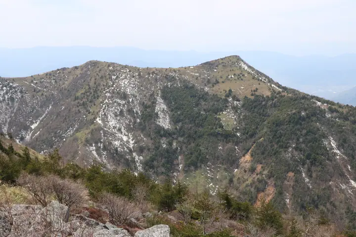
Also called Eboshidake, this twin-peaked mountain has a higher northern summit and a southern summit called Koeboshidake. A trail approaches from Yunomaru Highland. Its name is linked to its resemblance to an eboshi cap, and protected alpine butterflies inhabit the surrounding area.
Mount Eboshi at a glance
- Weather: The most settled day in the next 7 days is Wed, November 4: clear, gusts up to 8 m/s.
- Route: The shortest is Mount Yunomaru and Mount Eboshi Circuit from Jizō Pass: about 5 h 16 min, 9.2 km, about 660 m of climbing.
Mount Eboshi weather (hourly, 14 days)
Sunrise today 06:11, sunset 16:49
| Tue, 11/3 | Wed, 11/4 | Thu, 11/5 | Fri, 11/6 | Sat, 11/7 | Sun, 11/8 | Mon, 11/9 | Tue, 11/10 | Wed, 11/11 | Thu, 11/12 | Fri, 11/13 | Sat, 11/14 | Sun, 11/15 | Mon, 11/16 | Tue, 11/17 | |||||||||||||||||||||||||||||||||||||||||||||||||||||||||||||||||||||||
|---|---|---|---|---|---|---|---|---|---|---|---|---|---|---|---|---|---|---|---|---|---|---|---|---|---|---|---|---|---|---|---|---|---|---|---|---|---|---|---|---|---|---|---|---|---|---|---|---|---|---|---|---|---|---|---|---|---|---|---|---|---|---|---|---|---|---|---|---|---|---|---|---|---|---|---|---|---|---|---|---|---|---|---|---|---|
| Japan time | 15 | 17 | 19 | 21 | 23 | 1 | 3 | 5 | 7 | 9 | 11 | 13 | 15 | 18 | 21 | 0 | 3 | 6 | 9 | 12 | 15 | 18 | 21 | 0 | 3 | 6 | 9 | 12 | 15 | 18 | 21 | 0 | 3 | 6 | 9 | 12 | 15 | 18 | 21 | 0 | 3 | 6 | 9 | 12 | 15 | 18 | 21 | 0 | 3 | 6 | 9 | 15 | 21 | 3 | 9 | 15 | 21 | 3 | 9 | 15 | 21 | 3 | 9 | 15 | 21 | 3 | 9 | 15 | 21 | 3 | 9 | 15 | 21 | 3 | 9 | 15 | 21 | 3 | 9 | 15 | 21 | 3 | 9 | 15 | |
  |   | | | | | | |  | | | | |   | |   | | |   | | |   | | | |   | | | | | | | | | | |   | | | | | | | | | | | | | | | | | | | | |   |   |   | | | | | | |   | | |  | | | | | |   | | | | | | | | | ||
| Temperature | °C | 4° | 0° | -2° | -4° | -4° | -4° | -3° | -3° | -3° | 3° | 6° | 7° | 6° | 2° | 1° | 1° | 1° | 2° | 4° | 7° | 7° | 5° | 5° | 4° | 4° | 3° | 7° | 10° | 8° | 4° | 1° | 0° | -2° | -3° | -1° | 0° | 0° | -4° | -6° | -6° | -6° | -7° | -2° | 2° | 1° | -2° | -3° | -3° | -3° | -3° | 0° | 3° | -2° | -3° | 0° | 2° | -3° | -5° | -5° | -3° | -5° | -7° | -1° | 2° | -6° | -4° | -2° | -3° | -7° | -7° | -1° | 5° | -3° | -2° | 3° | 7° | 1° | 2° | 5° | 3° | -4° | -6° | -2° | 2° |
| Precipitation | mm | 0.8 | 10 | 4.0 | 1.5 | 1.0 | 0.2 | 0.2 | 0.5 | 0.8 | 0.2 | 1.5 | 1.8 | 1.4 | 0.1 | 0.1 | 6 | 6 | 0.4 | 0.1 | |||||||||||||||||||||||||||||||||||||||||||||||||||||||||||||||||
| New snow | cm | 0.9 | 1.7 | 1.0 | <.1 | ||||||||||||||||||||||||||||||||||||||||||||||||||||||||||||||||||||||||||||||||
| Snow depth | cm | 0 | 0 | 0 | 0 | 0 | 0 | 0 | 0 | 0 | 0 | 0 | 0 | 0 | 0 | 0 | 0 | 0 | 0 | 0 | 0 | 0 | 0 | 0 | 0 | 0 | 0 | 0 | 0 | 0 | 0 | 0 | 0 | 0 | 0 | 0 | 0 | 0 | 0 | 0 | 0 | 0 | 0 | 0 | 0 | 0 | 0 | 0 | 0 | 0 | 0 | 0 | 0 | 0 | 0 | 0 | 0 | 0 | <1 | 2 | 2 | 1 | 1 | 1 | <1 | <1 | <1 | <1 | 0 | 0 | 0 | 0 | 0 | 0 | 0 | 0 | 0 | 0 | 0 | 0 | 0 | 0 | 0 | 0 | 0 |
| Wind | m/s | 2 | 1 | 1 | 1 | 1 | 1 | 1 | 1 | 0 | 1 | 2 | 2 | 2 | 2 | 3 | 2 | 2 | 1 | 1 | 0 | 0 | 1 | 1 | 0 | 1 | 1 | 2 | 2 | 2 | 2 | 2 | 3 | 3 | 2 | 3 | 3 | 2 | 2 | 1 | 2 | 2 | 2 | 2 | 3 | 3 | 1 | 1 | 1 | 1 | 1 | 0 | 2 | 1 | 1 | 2 | 3 | 2 | 4 | 4 | 5 | 2 | 1 | 1 | 2 | 1 | 2 | 3 | 4 | 2 | 2 | 1 | 1 | 1 | 0 | 1 | 3 | 2 | 1 | 2 | 5 | 4 | 2 | 1 | 2 |
| Wind gusts | m/s | 8 | 8 | 5 | 3 | 3 | 3 | 2 | 2 | 2 | 5 | 6 | 7 | 8 | 8 | 9 | 10 | 8 | 7 | 6 | 5 | 6 | 4 | 4 | 5 | 5 | 5 | 8 | 10 | 10 | 8 | 8 | 9 | 10 | 11 | 11 | 13 | 11 | 9 | 8 | 7 | 8 | 8 | 8 | 10 | 11 | 9 | 4 | 5 | 5 | 5 | 6 | 9 | 7 | 4 | 6 | 10 | 10 | 13 | 19 | 20 | 18 | 9 | 6 | 8 | 7 | 6 | 10 | 14 | 14 | 8 | 6 | 6 | 5 | 4 | 6 | 11 | 10 | 11 | 9 | 17 | 17 | 14 | 7 | 7 |
| Wind dir. | ↓ | ↓ | ↓ | ↓ | ↓ | ↓ | ↓ | ↓ | ↓ | ↓ | ↓ | ↓ | ↓ | ↓ | ↓ | ↓ | ↓ | ↓ | ↓ | ↓ | ↓ | ↓ | ↓ | ↓ | ↓ | ↓ | ↓ | ↓ | ↓ | ↓ | ↓ | ↓ | ↓ | ↓ | ↓ | ↓ | ↓ | ↓ | ↓ | ↓ | ↓ | ↓ | ↓ | ↓ | ↓ | ↓ | ↓ | ↓ | ↓ | ↓ | ↓ | ↓ | ↓ | ↓ | ↓ | ↓ | ↓ | ↓ | ↓ | ↓ | ↓ | ↓ | ↓ | ↓ | ↓ | ↓ | ↓ | ↓ | ↓ | ↓ | ↓ | ↓ | ↓ | ↓ | ↓ | ↓ | ↓ | ↓ | ↓ | ↓ | ↓ | ↓ | ↓ | ↓ | |
Mount Eboshi hiking routes
Hiking times are estimates calculated from the terrain.
Huts, campsites and lodging near Mount Eboshi
Campsites
- 湯の丸キャンプ場
Lodging
- 紅葉館
Mount Eboshi facts
- Elevation
- 2,066 m
- Location
- Ueda, Nagano
36.433364, 138.387142 - Website
- tomikan.jp
- Wikipedia
- ja.wikipedia.org