
Mount Bandai
磐梯山
Inawashiro, Fukushima · Elevation 1,816 m
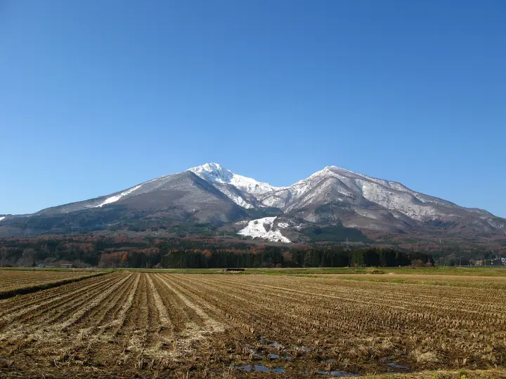
Mount Bandai is a 1,816 m active volcano in Inawashiro and a prominent mountain in Bandai-Asahi National Park. Its graceful southern face gives it the name Aizu Fuji, while the rugged explosion craters on its northern face give it the nickname Yamai-Bandai (the diseased Bandai). The 1888 phreatic eruption and edifice collapse created the lakes of Urabandai, including the Goshikinuma ponds and Lake Hibara. Trails start at Happodai, Inawashiro, Kawakami, Urabandai, and Okinashima; the shortest, from Happodai, takes about two hours ten minutes to reach the summit.
Mount Bandai at a glance
- Weather: The most settled day in the next 7 days is Wed, November 4: clear, gusts up to 6 m/s. Fri, Nov 6, Sat, Nov 7, Sun, Nov 8: strong wind (gusts up to 23 m/s).
- Route: The shortest is Mount Bandai Round Trip from Happodai: about 4 h 42 min, 7.3 km, about 690 m of climbing.
Mount Bandai weather (hourly, 14 days)
Sunrise today 06:06, sunset 16:41
| Tue, 11/3 | Wed, 11/4 | Thu, 11/5 | Fri, 11/6 | Sat, 11/7 | Sun, 11/8 | Mon, 11/9 | Tue, 11/10 | Wed, 11/11 | Thu, 11/12 | Fri, 11/13 | Sat, 11/14 | Sun, 11/15 | Mon, 11/16 | Tue, 11/17 | |||||||||||||||||||||||||||||||||||||||||||||||||||||||||||||||||||||||
|---|---|---|---|---|---|---|---|---|---|---|---|---|---|---|---|---|---|---|---|---|---|---|---|---|---|---|---|---|---|---|---|---|---|---|---|---|---|---|---|---|---|---|---|---|---|---|---|---|---|---|---|---|---|---|---|---|---|---|---|---|---|---|---|---|---|---|---|---|---|---|---|---|---|---|---|---|---|---|---|---|---|---|---|---|---|
| Japan time | 15 | 17 | 19 | 21 | 23 | 1 | 3 | 5 | 7 | 9 | 11 | 13 | 15 | 18 | 21 | 0 | 3 | 6 | 9 | 12 | 15 | 18 | 21 | 0 | 3 | 6 | 9 | 12 | 15 | 18 | 21 | 0 | 3 | 6 | 9 | 12 | 15 | 18 | 21 | 0 | 3 | 6 | 9 | 12 | 15 | 18 | 21 | 0 | 3 | 6 | 9 | 15 | 21 | 3 | 9 | 15 | 21 | 3 | 9 | 15 | 21 | 3 | 9 | 15 | 21 | 3 | 9 | 15 | 21 | 3 | 9 | 15 | 21 | 3 | 9 | 15 | 21 | 3 | 9 | 15 | 21 | 3 | 9 | 15 | |
 |  | | | | | |   | |   | | | | |   |   | | |   |   |   | |   | | | | | | | | | | | |   |   |   | | |   | |   |   |   |   | | | |   | | | | | | | | | | | | | | | | | | | | | | | |  | | | | |   | | | | | | | ||
| Temperature | °C | 3° | -1° | -2° | -3° | -3° | -3° | -3° | -4° | -2° | 2° | 5° | 6° | 6° | 0° | 2° | 1° | 2° | 3° | 5° | 6° | 8° | 4° | 4° | 5° | 4° | 4° | 5° | 5° | 6° | 3° | 1° | 0° | -2° | -3° | -4° | -3° | -2° | -4° | -4° | -4° | -4° | -5° | -2° | 0° | -1° | -3° | -4° | -4° | -4° | -4° | -1° | 1° | -3° | -7° | 0° | 1° | -2° | -4° | -4° | 0° | -3° | -4° | -2° | -1° | -2° | -3° | -2° | -2° | -5° | -5° | -2° | 2° | -3° | -3° | 3° | 6° | 1° | 3° | 4° | 2° | -4° | -6° | -3° | 0° |
| Precipitation | mm | 1.9 | 4.3 | 11 | 7 | 2.7 | 0.2 | 0.8 | 2.3 | 0.3 | 1.6 | 0.6 | 0.2 | 0.7 | 1.3 | 1.8 | 2.4 | 1.0 | 0.1 | 0.2 | 0.1 | 0.6 | 0.5 | 0.2 | 0.2 | 4.8 | 2.4 | 1.0 | 0.2 | 0.3 | 0.3 | 1.4 | 0.1 | 3.7 | 7 | 0.3 | 2.6 | 0.8 | |||||||||||||||||||||||||||||||||||||||||||||||
| New snow | cm | 0.4 | 0.8 | 0.5 | <.1 | 0.1 | 0.2 | <.1 | <.1 | <.1 | <.1 | 0.3 | 0.3 | <.1 | 1.0 | 1.6 | 0.1 | <.1 | <.1 | 0.2 | <.1 | <.1 | <.1 | ||||||||||||||||||||||||||||||||||||||||||||||||||||||||||||||
| Snow depth | cm | 0 | 0 | 0 | 0 | 0 | 0 | 0 | 0 | 0 | 0 | 0 | 0 | 0 | 0 | 0 | 0 | 0 | 0 | 0 | 0 | 0 | 0 | 0 | 0 | 0 | 0 | 0 | 0 | 0 | 0 | 0 | 0 | 0 | 0 | 0 | <1 | <1 | <1 | <1 | <1 | <1 | <1 | <1 | <1 | <1 | 0 | 0 | 0 | <1 | <1 | <1 | 0 | 0 | 0 | 0 | 0 | 0 | <1 | 2 | 1 | <1 | <1 | <1 | 0 | 0 | 0 | 0 | 0 | 0 | 0 | 0 | 0 | 0 | 0 | 0 | 0 | 0 | 0 | 0 | 0 | 0 | 0 | 0 | 0 |
| Wind | m/s | 5 | 1 | 1 | 1 | 1 | 1 | 1 | 1 | 1 | 1 | 1 | 2 | 2 | 3 | 3 | 2 | 2 | 1 | 1 | 0 | 1 | 1 | 1 | 1 | 1 | 2 | 4 | 6 | 6 | 5 | 4 | 3 | 4 | 3 | 5 | 5 | 7 | 5 | 6 | 6 | 6 | 4 | 6 | 6 | 5 | 2 | 1 | 1 | 1 | 1 | 1 | 3 | 1 | 1 | 1 | 4 | 2 | 4 | 3 | 6 | 4 | 1 | 1 | 4 | 0 | 1 | 4 | 5 | 3 | 1 | 1 | 1 | 0 | 1 | 1 | 1 | 1 | 1 | 1 | 4 | 4 | 3 | 2 | 2 |
| Wind gusts | m/s | 15 | 13 | 6 | 6 | 5 | 5 | 5 | 4 | 4 | 4 | 5 | 6 | 6 | 8 | 9 | 9 | 9 | 7 | 9 | 7 | 5 | 4 | 4 | 5 | 6 | 10 | 13 | 18 | 20 | 18 | 17 | 14 | 15 | 15 | 18 | 21 | 23 | 20 | 17 | 18 | 17 | 17 | 17 | 19 | 18 | 14 | 8 | 6 | 5 | 4 | 6 | 9 | 9 | 6 | 4 | 11 | 12 | 12 | 13 | 18 | 17 | 13 | 7 | 13 | 12 | 8 | 12 | 15 | 15 | 11 | 6 | 7 | 5 | 5 | 5 | 6 | 5 | 6 | 8 | 13 | 17 | 12 | 9 | 7 |
| Wind dir. | ↓ | ↓ | ↓ | ↓ | ↓ | ↓ | ↓ | ↓ | ↓ | ↓ | ↓ | ↓ | ↓ | ↓ | ↓ | ↓ | ↓ | ↓ | ↓ | ↓ | ↓ | ↓ | ↓ | ↓ | ↓ | ↓ | ↓ | ↓ | ↓ | ↓ | ↓ | ↓ | ↓ | ↓ | ↓ | ↓ | ↓ | ↓ | ↓ | ↓ | ↓ | ↓ | ↓ | ↓ | ↓ | ↓ | ↓ | ↓ | ↓ | ↓ | ↓ | ↓ | ↓ | ↓ | ↓ | ↓ | ↓ | ↓ | ↓ | ↓ | ↓ | ↓ | ↓ | ↓ | ↓ | ↓ | ↓ | ↓ | ↓ | ↓ | ↓ | ↓ | ↓ | ↓ | ↓ | ↓ | ↓ | ↓ | ↓ | ↓ | ↓ | ↓ | ↓ | ↓ | |
Mount Bandai live cameras
Mount Bandai hiking routes
- Mount Bandai Round Trip from Happodai 7.3 km · Ascent 693 m Happodai Parking Lot
- Mount Bandai, Return from beside the Ski Slopes on the Lake Inawashiro Side via Tengu Rock and Kobo Shimizu 6.5 km · Ascent 1,008 m parking
- Mount Bandai Out-and-Back from the Inawashiro Ski Resort Summer Lift 7.3 km · Ascent 784 m
- Mount Bandai Loop from the Urabandai Trailhead 10.2 km · Ascent 961 m parking
- Mount Akahani and Mount Bandai Round Trip from Inawashiro Trailhead 12.9 km · Ascent 1,218 m 猪苗代登山口, はやま中央駐車場, さんすい駐車場, はやま 中央駐車場 D面
Hiking times are estimates calculated from the terrain.
Huts, campsites and lodging near Mount Bandai
Mountain huts
Lodging
- 猪苗代リゾートホテル
- Hoshino Resorts Bandaisan Onsen Hotel
- 国立磐梯青少年交流の家
Lists that include Mount Bandai
100 Famous Japanese Mountains · Japan 200 Famous Mountains · Japan's 300 Famous Mountains · New Japan 100 Famous Mountains · Illustrated Collection of Japan's Famous Mountains · 100 Famous Hot Spring Mountains · 100 Fujis of Japan · Tohoku 100 Famous Mountains · Utsukushima 100 Famous Mountains (Fukushima Prefecture) · Aizu 100 Famous Mountains · 30 Peaks of Fukushima · Elevations of 1003 Mountains of Japan · 1000 Mountains of Japan
Mount Bandai facts
- Also known as
- 会津富士 · 会津磐梯山 · 病磐梯
- Elevation
- 1,816 m
- Location
- Inawashiro, Fukushima
37.600981, 140.072245 - National Park
- 磐梯朝日国立公園
- Volcano
- Active volcano (磐梯山)
- Website
- www.bandaisan.or.jp
- Trail Map
- www.bandaisan.or.jp (PDF)
- Access Information
- urabandai-vc.jp
- Wikipedia
- ja.wikipedia.org