
Mt. Nekoma
猫魔ヶ岳
Kitashiobara, Fukushima · Elevation 1,404 m
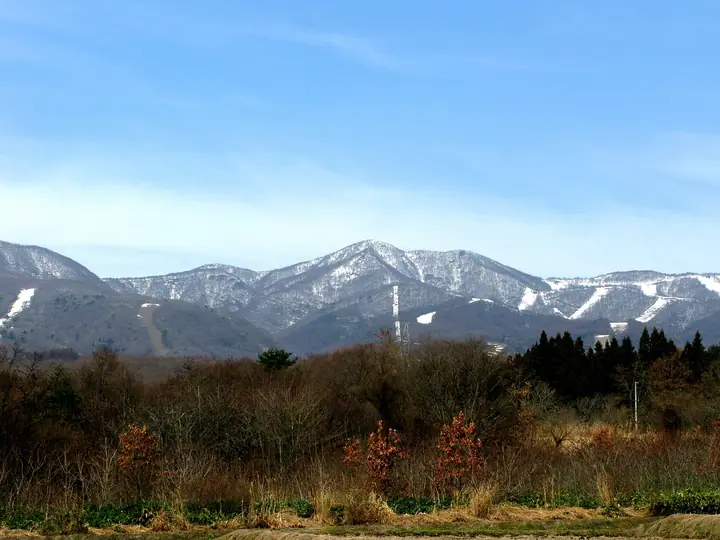
Mt. Nekoma (1,404 m) rises on the border between Kitashiobara Village and Bandai Town in Yama District, Fukushima Prefecture, within Bandai-Asahi National Park, and is included in the Utsukushima 100, Aizu 100 and Japan 100 Low-Famous Mountains lists, among others. It stands at the western edge of the Oguni-numa caldera, just west of Mt. Bandai, and is most often climbed from the Happōdai trailhead at the high point of the Bandai Gold Line — making a same-day combination with Mt. Bandai practical. The slopes are wrapped in old-growth beech forest, and the mountain is celebrated as one of the 50 Flower Mountains for its abundant spring alpine bloom.
Mt. Nekoma at a glance
- Weather: The most settled day in the next 7 days is Wed, November 4: clear, gusts up to 6 m/s. Fri, Nov 6, Sat, Nov 7, Sun, Nov 8: strong wind (gusts up to 23 m/s).
- Route: The shortest is Mount Nekoma in Urabandai, Return from Happodai over the Summit to Neko-ishi Rock: about 3 h 10 min, 5.2 km, about 420 m of climbing.
Mt. Nekoma weather (hourly, 14 days)
Sunrise today 06:06, sunset 16:41
| Tue, 11/3 | Wed, 11/4 | Thu, 11/5 | Fri, 11/6 | Sat, 11/7 | Sun, 11/8 | Mon, 11/9 | Tue, 11/10 | Wed, 11/11 | Thu, 11/12 | Fri, 11/13 | Sat, 11/14 | Sun, 11/15 | Mon, 11/16 | Tue, 11/17 | |||||||||||||||||||||||||||||||||||||||||||||||||||||||||||||||||||||||
|---|---|---|---|---|---|---|---|---|---|---|---|---|---|---|---|---|---|---|---|---|---|---|---|---|---|---|---|---|---|---|---|---|---|---|---|---|---|---|---|---|---|---|---|---|---|---|---|---|---|---|---|---|---|---|---|---|---|---|---|---|---|---|---|---|---|---|---|---|---|---|---|---|---|---|---|---|---|---|---|---|---|---|---|---|---|
| Japan time | 15 | 17 | 19 | 21 | 23 | 1 | 3 | 5 | 7 | 9 | 11 | 13 | 15 | 18 | 21 | 0 | 3 | 6 | 9 | 12 | 15 | 18 | 21 | 0 | 3 | 6 | 9 | 12 | 15 | 18 | 21 | 0 | 3 | 6 | 9 | 12 | 15 | 18 | 21 | 0 | 3 | 6 | 9 | 12 | 15 | 18 | 21 | 0 | 3 | 6 | 9 | 15 | 21 | 3 | 9 | 15 | 21 | 3 | 9 | 15 | 21 | 3 | 9 | 15 | 21 | 3 | 9 | 15 | 21 | 3 | 9 | 15 | 21 | 3 | 9 | 15 | 21 | 3 | 9 | 15 | 21 | 3 | 9 | 15 | |
 |  | | | | | |   | |   | | | | |   |   | | |   |   |   | |   | | | | | | | | | | | |   |   |   | | |   | |   |   |   |   | | | |   | | | | | | | | | | | | | | | | | | | | | | | |  | | | | |   | | | | | | | ||
| Temperature | °C | 6° | 1° | 1° | 0° | 0° | -1° | -1° | -1° | 1° | 5° | 8° | 9° | 9° | 3° | 4° | 4° | 5° | 6° | 7° | 9° | 11° | 7° | 6° | 7° | 6° | 6° | 7° | 8° | 8° | 5° | 4° | 2° | 0° | 0° | -1° | 0° | 1° | -1° | -2° | -1° | -1° | -2° | 1° | 3° | 2° | -1° | -1° | -1° | -1° | -1° | 2° | 4° | -1° | -4° | 2° | 4° | 0° | -1° | -1° | 2° | 0° | -1° | 0° | 2° | 0° | 0° | 1° | 1° | -2° | -3° | 1° | 5° | 0° | 0° | 6° | 8° | 4° | 6° | 6° | 5° | -1° | -3° | 0° | 2° |
| Precipitation | mm | 1.9 | 4.3 | 11 | 7 | 2.7 | 0.2 | 0.8 | 2.3 | 0.3 | 1.6 | 0.6 | 0.2 | 0.7 | 1.3 | 1.8 | 2.4 | 1.0 | 0.1 | 0.2 | 0.1 | 0.6 | 0.5 | 0.2 | 0.2 | 4.8 | 2.4 | 1.0 | 0.2 | 0.3 | 0.3 | 1.4 | 0.1 | 3.7 | 7 | 0.3 | 2.6 | 0.8 | |||||||||||||||||||||||||||||||||||||||||||||||
| New snow | cm | 0.4 | 0.8 | 0.5 | <.1 | 0.1 | 0.2 | <.1 | <.1 | <.1 | <.1 | 0.3 | 0.3 | <.1 | 1.0 | 1.6 | 0.1 | <.1 | <.1 | 0.2 | <.1 | <.1 | <.1 | ||||||||||||||||||||||||||||||||||||||||||||||||||||||||||||||
| Snow depth | cm | 0 | 0 | 0 | 0 | 0 | 0 | 0 | 0 | 0 | 0 | 0 | 0 | 0 | 0 | 0 | 0 | 0 | 0 | 0 | 0 | 0 | 0 | 0 | 0 | 0 | 0 | 0 | 0 | 0 | 0 | 0 | 0 | 0 | 0 | 0 | <1 | <1 | <1 | <1 | <1 | <1 | <1 | <1 | <1 | <1 | 0 | 0 | 0 | <1 | <1 | <1 | 0 | 0 | 0 | 0 | 0 | 0 | <1 | 2 | 1 | <1 | <1 | <1 | 0 | 0 | 0 | 0 | 0 | 0 | 0 | 0 | 0 | 0 | 0 | 0 | 0 | 0 | 0 | 0 | 0 | 0 | 0 | 0 | 0 |
| Wind | m/s | 5 | 1 | 1 | 1 | 1 | 1 | 1 | 1 | 1 | 1 | 1 | 2 | 2 | 3 | 3 | 2 | 2 | 1 | 1 | 0 | 1 | 1 | 1 | 1 | 1 | 2 | 4 | 6 | 6 | 5 | 4 | 3 | 4 | 3 | 5 | 5 | 7 | 5 | 6 | 6 | 6 | 4 | 6 | 6 | 5 | 2 | 1 | 1 | 1 | 1 | 1 | 3 | 1 | 1 | 1 | 4 | 2 | 4 | 3 | 6 | 4 | 1 | 1 | 4 | 0 | 1 | 4 | 5 | 3 | 1 | 1 | 1 | 0 | 1 | 1 | 1 | 1 | 1 | 1 | 4 | 4 | 3 | 2 | 2 |
| Wind gusts | m/s | 15 | 13 | 6 | 6 | 5 | 5 | 5 | 4 | 4 | 4 | 5 | 6 | 6 | 8 | 9 | 9 | 9 | 7 | 9 | 7 | 5 | 4 | 4 | 5 | 6 | 10 | 13 | 18 | 20 | 18 | 17 | 14 | 15 | 15 | 18 | 21 | 23 | 20 | 17 | 18 | 17 | 17 | 17 | 19 | 18 | 14 | 8 | 6 | 5 | 4 | 6 | 9 | 9 | 6 | 4 | 11 | 12 | 12 | 13 | 18 | 17 | 13 | 7 | 13 | 12 | 8 | 12 | 15 | 15 | 11 | 6 | 7 | 5 | 5 | 5 | 6 | 5 | 6 | 8 | 13 | 17 | 12 | 9 | 7 |
| Wind dir. | ↓ | ↓ | ↓ | ↓ | ↓ | ↓ | ↓ | ↓ | ↓ | ↓ | ↓ | ↓ | ↓ | ↓ | ↓ | ↓ | ↓ | ↓ | ↓ | ↓ | ↓ | ↓ | ↓ | ↓ | ↓ | ↓ | ↓ | ↓ | ↓ | ↓ | ↓ | ↓ | ↓ | ↓ | ↓ | ↓ | ↓ | ↓ | ↓ | ↓ | ↓ | ↓ | ↓ | ↓ | ↓ | ↓ | ↓ | ↓ | ↓ | ↓ | ↓ | ↓ | ↓ | ↓ | ↓ | ↓ | ↓ | ↓ | ↓ | ↓ | ↓ | ↓ | ↓ | ↓ | ↓ | ↓ | ↓ | ↓ | ↓ | ↓ | ↓ | ↓ | ↓ | ↓ | ↓ | ↓ | ↓ | ↓ | ↓ | ↓ | ↓ | ↓ | ↓ | ↓ | |
Mt. Nekoma hiking routes
Hiking times are estimates calculated from the terrain.
Huts, campsites and lodging near Mt. Nekoma
Mountain huts
Lodging
- Hoshino Resorts Bandaisan Onsen Hotel
- 猪苗代リゾートホテル
Lists that include Mt. Nekoma
100 Low Mountains of Japan · Utsukushima 100 Famous Mountains (Fukushima Prefecture) · Aizu 100 Famous Mountains · 1000 Mountains of Japan
Mt. Nekoma facts
- Elevation
- 1,404 m
- Location
- Kitashiobara, Fukushima
37.611656, 140.028375 - National Park
- 磐梯朝日国立公園
- Website
- urabandai-vc.jp
- Trail Map
- urabandai-vc.jp (PDF)
- Wikipedia
- ja.wikipedia.org