
Mount Asakusa
浅草岳
Uonuma, Niigata · Elevation 1,586 m
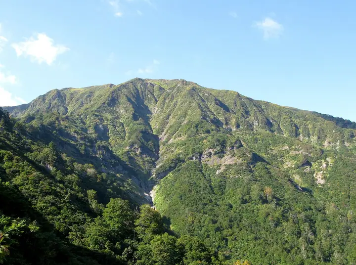
Mount Asakusa is a 1,585.5 m Quaternary volcano straddling Uonuma City in Niigata Prefecture and Tadami Town in Minamiaizu District, Fukushima Prefecture, a celebrated peak on the historic Aizu–Echigo border. It carries a first-order triangulation marker and is listed in the Nihon Sanbyaku Meizan, the Shin Hana no Hyakumeizan, the Ittō-Sankakuten Hyakumeizan, the Tōhoku 100 Meizan, the Niigata 100 Meizan, the Aizu Hyakumeizan, and the Tadami Yon Meizan. Its broad summit grassland fills with Himesayuri, Shirane-aoi, and Nikkō-kisuge in July, putting the mountain firmly among Japan's classic flower peaks. Five trails serve the summit — the Nezumochi-daira route (the shortest, with a large car park and toilet) and the Sakura-zone route on the Niigata side, plus the Tagokurako and Iri-Kanōtsu routes on the Fukushima side — and the cross-border traverse over the summit ridge is a celebrated walk in its own right.
Mount Asakusa at a glance
- Weather: The most settled day in the next 7 days is Wed, November 4: clear, gusts up to 8 m/s. Fri, Nov 6, Sat, Nov 7: strong wind (gusts up to 23 m/s).
- Route: The shortest is Mount Asakusa Loop via Mount Maedake and Kaheyonobocchi from Nezumochidaira: about 4 h 27 min, 7.8 km, about 760 m of climbing.
Mount Asakusa weather (hourly, 14 days)
Sunrise today 06:09, sunset 16:44
| Tue, 11/3 | Wed, 11/4 | Thu, 11/5 | Fri, 11/6 | Sat, 11/7 | Sun, 11/8 | Mon, 11/9 | Tue, 11/10 | Wed, 11/11 | Thu, 11/12 | Fri, 11/13 | Sat, 11/14 | Sun, 11/15 | Mon, 11/16 | Tue, 11/17 | |||||||||||||||||||||||||||||||||||||||||||||||||||||||||||||||||||||||
|---|---|---|---|---|---|---|---|---|---|---|---|---|---|---|---|---|---|---|---|---|---|---|---|---|---|---|---|---|---|---|---|---|---|---|---|---|---|---|---|---|---|---|---|---|---|---|---|---|---|---|---|---|---|---|---|---|---|---|---|---|---|---|---|---|---|---|---|---|---|---|---|---|---|---|---|---|---|---|---|---|---|---|---|---|---|
| Japan time | 21 | 23 | 1 | 3 | 5 | 7 | 9 | 11 | 13 | 15 | 17 | 19 | 21 | 0 | 3 | 6 | 9 | 12 | 15 | 18 | 21 | 0 | 3 | 6 | 9 | 12 | 15 | 18 | 21 | 0 | 3 | 6 | 9 | 12 | 15 | 18 | 21 | 0 | 3 | 6 | 9 | 12 | 15 | 18 | 21 | 0 | 3 | 6 | 9 | 12 | 15 | 21 | 3 | 9 | 15 | 21 | 3 | 9 | 15 | 21 | 3 | 9 | 15 | 21 | 3 | 9 | 15 | 21 | 3 | 9 | 15 | 21 | 3 | 9 | 15 | 21 | 3 | 9 | 15 | 21 | 3 | 9 | 15 | 21 | |
 | | | |   |  | | | |   |   | |   |   |   | |   | | | | |   | | |   | | | | | | | |   | | | | |   | | | | | | | | | | | | |   | | | | | | |   | | | |   | | | | | | | | | |  | | |   | | | | | | | | |  | ||
| Temperature | °C | -3° | -3° | -3° | -2° | -2° | -1° | 4° | 7° | 8° | 7° | 4° | 2° | 2° | 2° | 2° | 3° | 5° | 9° | 10° | 6° | 6° | 5° | 5° | 6° | 6° | 7° | 5° | 3° | 2° | 0° | -1° | -1° | -2° | -1° | -3° | -3° | -3° | -3° | -3° | -3° | -2° | 0° | 0° | -2° | -4° | -3° | -3° | -2° | 1° | 6° | 3° | -2° | -5° | 1° | 8° | 1° | -4° | -1° | -1° | -2° | -2° | 0° | 1° | -4° | -1° | -1° | -1° | -2° | -3° | 1° | 5° | -4° | -5° | 4° | 8° | 2° | 2° | 5° | 2° | -3° | -4° | -1° | 1° | -4° |
| Precipitation | mm | 2.1 | 9 | 7 | 3.1 | 0.2 | 0.5 | 0.4 | 4.6 | 3.3 | 3.0 | 2.8 | 2.8 | 2.1 | 5 | 4.8 | 4.2 | 6 | 4.9 | 2.5 | 1.2 | 0.5 | 0.8 | 1.5 | 0.5 | 1.0 | 1.3 | 0.1 | 0.2 | 0.9 | 11 | 6 | 2.6 | 1.6 | 0.3 | 0.3 | 0.6 | 2.1 | 13 | 0.2 | 4.4 | 6 | 3.3 | 6 | 4.6 | 0.3 | |||||||||||||||||||||||||||||||||||||||
| New snow | cm | 0.1 | <.1 | <.1 | <.1 | <.1 | 0.4 | 3.4 | 5.3 | ||||||||||||||||||||||||||||||||||||||||||||||||||||||||||||||||||||||||||||
| Snow depth | cm | 0 | 0 | 0 | 0 | 0 | 0 | 0 | 0 | 0 | 0 | 0 | 0 | 0 | 0 | 0 | 0 | 0 | 0 | 0 | 0 | 0 | 0 | 0 | 0 | 0 | 0 | 0 | 0 | 0 | 0 | 0 | 0 | 0 | 0 | 0 | 0 | 0 | 0 | 0 | 0 | 0 | 0 | 0 | 0 | 0 | 0 | 0 | 0 | 0 | 0 | 0 | 0 | 0 | 0 | 0 | 0 | 2 | 4 | <1 | 0 | 0 | 0 | 0 | 0 | 0 | 0 | 0 | 0 | 0 | 0 | 0 | 0 | 0 | 0 | 0 | 0 | 0 | 0 | 0 | 0 | 0 | 0 | 0 | 0 |
| Wind | m/s | 1 | 1 | 1 | 1 | 1 | 0 | 1 | 2 | 3 | 3 | 3 | 2 | 2 | 2 | 2 | 2 | 3 | 2 | 1 | 0 | 1 | 0 | 1 | 4 | 5 | 6 | 6 | 5 | 4 | 4 | 4 | 5 | 4 | 6 | 6 | 6 | 6 | 5 | 5 | 5 | 4 | 4 | 3 | 1 | 0 | 1 | 0 | 1 | 2 | 2 | 3 | 0 | 0 | 2 | 2 | 1 | 3 | 4 | 5 | 3 | 1 | 3 | 3 | 1 | 4 | 3 | 5 | 2 | 1 | 0 | 2 | 0 | 0 | 1 | 1 | 1 | 1 | 3 | 6 | 5 | 3 | 1 | 2 | 0 |
| Wind gusts | m/s | 5 | 4 | 4 | 4 | 4 | 3 | 4 | 5 | 7 | 8 | 8 | 8 | 6 | 7 | 6 | 8 | 8 | 7 | 5 | 2 | 4 | 4 | 5 | 12 | 15 | 18 | 18 | 18 | 18 | 15 | 14 | 17 | 17 | 21 | 23 | 21 | 18 | 16 | 15 | 15 | 13 | 12 | 13 | 9 | 4 | 3 | 3 | 3 | 4 | 8 | 10 | 7 | 2 | 6 | 8 | 8 | 15 | 21 | 20 | 16 | 8 | 8 | 10 | 9 | 13 | 12 | 14 | 13 | 6 | 4 | 6 | 6 | 3 | 3 | 5 | 6 | 4 | 9 | 16 | 17 | 14 | 8 | 6 | 5 |
| Wind dir. | ↓ | ↓ | ↓ | ↓ | ↓ | ↓ | ↓ | ↓ | ↓ | ↓ | ↓ | ↓ | ↓ | ↓ | ↓ | ↓ | ↓ | ↓ | ↓ | ↓ | ↓ | ↓ | ↓ | ↓ | ↓ | ↓ | ↓ | ↓ | ↓ | ↓ | ↓ | ↓ | ↓ | ↓ | ↓ | ↓ | ↓ | ↓ | ↓ | ↓ | ↓ | ↓ | ↓ | ↓ | ↓ | ↓ | ↓ | ↓ | ↓ | ↓ | ↓ | ↓ | ↓ | ↓ | ↓ | ↓ | ↓ | ↓ | ↓ | ↓ | ↓ | ↓ | ↓ | ↓ | ↓ | ↓ | ↓ | ↓ | ↓ | ↓ | ↓ | ↓ | ↓ | ↓ | ↓ | ↓ | ↓ | ↓ | ↓ | ↓ | ↓ | ↓ | ↓ | ↓ | |
Mount Asakusa hiking routes
Hiking times are estimates calculated from the terrain.
Lists that include Mount Asakusa
Japan's 300 Famous Mountains · New 100 Famous Flower Mountains · 100 Famous Mountains with First-order Triangulation Points · Tohoku 100 Famous Mountains · Koshinetsu 100 Famous Mountains · Niigata 100 Famous Mountains · Utsukushima 100 Famous Mountains (Fukushima Prefecture) · Aizu 100 Famous Mountains · 30 Peaks of Fukushima · Elevations of 1003 Mountains of Japan · 1000 Mountains of Japan
Mount Asakusa facts
- Elevation
- 1,586 m
- Location
- Uonuma, Niigata
37.343605, 139.233583 - Website
- www.iine-uonuma.jp
- Trail Map
- www.tadami-net.com
- Access Information
- www.iine-uonuma.jp
- Wikipedia
- ja.wikipedia.org