
Mount Asakusa
浅草岳
อูโอนูมะ, นีงาตะ · ความสูง 1,586 ม.
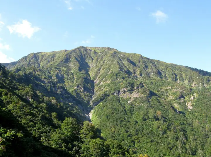
Mount Asakusa is a 1,585.5 m Quaternary volcano straddling Uonuma City in Niigata Prefecture and Tadami Town in Minamiaizu District, Fukushima Prefecture, a celebrated peak on the historic Aizu–Echigo border. It carries a first-order triangulation marker and is listed in the Nihon Sanbyaku Meizan, the Shin Hana no Hyakumeizan, the Ittō-Sankakuten Hyakumeizan, the Tōhoku 100 Meizan, the Niigata 100 Meizan, the Aizu Hyakumeizan, and the Tadami Yon Meizan. Its broad summit grassland fills with Himesayuri, Shirane-aoi, and Nikkō-kisuge in July, putting the mountain firmly among Japan's classic flower peaks. Five trails serve the summit — the Nezumochi-daira route (the shortest, with a large car park and toilet) and the Sakura-zone route on the Niigata side, plus the Tagokurako and Iri-Kanōtsu routes on the Fukushima side — and the cross-border traverse over the summit ridge is a celebrated walk in its own right.
สรุป Mount Asakusa
- อากาศ: วันที่อากาศคงที่ที่สุดใน 7 วันข้างหน้าคือ พุธ 4 พฤศจิกายน: ท้องฟ้าแจ่มใส ลมกระโชกสูงสุด 8 ม./วินาที ศุกร์ 6 พ.ย., เสาร์ 7 พ.ย. ลมแรง (ลมกระโชกสูงสุด 21 ม./วินาที)
- เส้นทาง: เส้นทางที่สั้นที่สุดคือ Mount Asakusa Loop via Mount Maedake and Kaheyonobocchi from Nezumochidaira: ประมาณ 4 ชม. 27 นาที 7.8 km ขึ้นประมาณ 760 m
อากาศ Mount Asakusa (รายชั่วโมง 2 สัปดาห์)
วันนี้พระอาทิตย์ขึ้น 06:09 ตก 16:44
| อังคาร 3/11 | พุธ 4/11 | พฤหัส 5/11 | ศุกร์ 6/11 | เสาร์ 7/11 | อาทิตย์ 8/11 | จันทร์ 9/11 | อังคาร 10/11 | พุธ 11/11 | พฤหัส 12/11 | ศุกร์ 13/11 | เสาร์ 14/11 | อาทิตย์ 15/11 | จันทร์ 16/11 | อังคาร 17/11 | |||||||||||||||||||||||||||||||||||||||||||||||||||||||||||||||||||||||
|---|---|---|---|---|---|---|---|---|---|---|---|---|---|---|---|---|---|---|---|---|---|---|---|---|---|---|---|---|---|---|---|---|---|---|---|---|---|---|---|---|---|---|---|---|---|---|---|---|---|---|---|---|---|---|---|---|---|---|---|---|---|---|---|---|---|---|---|---|---|---|---|---|---|---|---|---|---|---|---|---|---|---|---|---|---|
| เวลาญี่ปุ่น | 15 | 17 | 19 | 21 | 23 | 1 | 3 | 5 | 7 | 9 | 11 | 13 | 15 | 18 | 21 | 0 | 3 | 6 | 9 | 12 | 15 | 18 | 21 | 0 | 3 | 6 | 9 | 12 | 15 | 18 | 21 | 0 | 3 | 6 | 9 | 12 | 15 | 18 | 21 | 0 | 3 | 6 | 9 | 12 | 15 | 18 | 21 | 0 | 3 | 6 | 9 | 15 | 21 | 3 | 9 | 15 | 21 | 3 | 9 | 15 | 21 | 3 | 9 | 15 | 21 | 3 | 9 | 15 | 21 | 3 | 9 | 15 | 21 | 3 | 9 | 15 | 21 | 3 | 9 | 15 | 21 | 3 | 9 | 15 | |
  |   | |  | | | | | |  | | | | |   |   | | |   |   | | | |   | | | | | | | | | | |   | | | | | | | | | | | | | | | | |   | | | | | |   |   | | | | | | | | | | | | | |  | | |   | | | | | | | | | ||
| อุณหภูมิ | °C | 4° | 0° | -1° | -3° | -3° | -3° | -3° | -2° | -1° | 4° | 7° | 8° | 8° | 2° | 2° | 2° | 2° | 3° | 4° | 6° | 8° | 5° | 6° | 5° | 3° | 5° | 6° | 6° | 7° | 4° | 2° | 0° | 0° | -2° | -2° | -2° | -2° | -3° | -3° | -3° | -3° | -3° | -1° | 1° | 0° | -1° | -2° | -3° | -3° | -3° | 0° | 1° | -2° | -5° | 1° | 8° | 1° | -4° | -1° | -1° | -2° | -2° | 0° | 1° | -4° | -1° | -1° | -1° | -2° | -3° | 1° | 5° | -4° | -5° | 4° | 8° | 2° | 2° | 5° | 2° | -3° | -4° | -1° | 1° |
| ฝนและหิมะ | mm | 0.2 | 6 | 11 | 1.9 | 1.6 | 0.1 | 1.9 | 2.8 | 5.0 | 1.0 | 1.7 | 4.0 | 3.0 | 4.5 | 6 | 7 | 4.2 | 2.1 | 1.5 | 1.2 | 0.7 | 1.5 | 1.3 | 0.7 | 0.8 | 0.4 | 0.2 | 0.3 | 0.9 | 0.8 | 0.2 | 0.2 | 0.9 | 11 | 6 | 2.6 | 1.6 | 0.3 | 0.3 | 0.6 | 2.1 | 13 | 0.2 | 4.4 | 6 | 3.3 | 6 | 4.6 | 0.3 | |||||||||||||||||||||||||||||||||||
| หิมะตก | cm | 0.2 | 0.2 | 0.2 | <.1 | <.1 | 3.4 | 5.3 | |||||||||||||||||||||||||||||||||||||||||||||||||||||||||||||||||||||||||||||
| หิมะสะสม | cm | 0 | 0 | 0 | 0 | 0 | 0 | 0 | 0 | 0 | 0 | 0 | 0 | 0 | 0 | 0 | 0 | 0 | 0 | 0 | 0 | 0 | 0 | 0 | 0 | 0 | 0 | 0 | 0 | 0 | 0 | 0 | 0 | 0 | 0 | 0 | 0 | 0 | 0 | 0 | 0 | 0 | 0 | 0 | 0 | 0 | 0 | 0 | 0 | 0 | 0 | 0 | 0 | 0 | 0 | 0 | 0 | 0 | 2 | 4 | <1 | 0 | 0 | 0 | 0 | 0 | 0 | 0 | 0 | 0 | 0 | 0 | 0 | 0 | 0 | 0 | 0 | 0 | 0 | 0 | 0 | 0 | 0 | 0 | 0 |
| ลม | m/s | 4 | 2 | 1 | 1 | 1 | 1 | 1 | 1 | 0 | 1 | 2 | 2 | 3 | 2 | 2 | 2 | 2 | 2 | 2 | 2 | 1 | 1 | 2 | 1 | 1 | 2 | 4 | 5 | 6 | 5 | 4 | 4 | 4 | 5 | 4 | 6 | 6 | 5 | 5 | 5 | 5 | 4 | 4 | 5 | 4 | 1 | 1 | 0 | 1 | 1 | 1 | 2 | 0 | 0 | 2 | 2 | 1 | 3 | 4 | 5 | 3 | 1 | 3 | 3 | 1 | 4 | 3 | 5 | 2 | 1 | 0 | 2 | 0 | 0 | 1 | 1 | 1 | 1 | 3 | 6 | 5 | 3 | 1 | 2 |
| ลมกระโชก | m/s | 13 | 10 | 6 | 4 | 4 | 4 | 4 | 4 | 3 | 3 | 5 | 6 | 8 | 8 | 5 | 7 | 6 | 7 | 8 | 5 | 5 | 4 | 6 | 6 | 5 | 8 | 14 | 17 | 18 | 18 | 15 | 15 | 17 | 18 | 16 | 20 | 21 | 19 | 16 | 16 | 14 | 14 | 12 | 14 | 15 | 10 | 5 | 4 | 3 | 3 | 4 | 8 | 7 | 2 | 6 | 8 | 8 | 15 | 21 | 20 | 16 | 8 | 8 | 10 | 9 | 13 | 12 | 14 | 13 | 6 | 4 | 6 | 6 | 3 | 3 | 5 | 6 | 4 | 9 | 16 | 17 | 14 | 8 | 6 |
| ทิศทางลม | ↓ | ↓ | ↓ | ↓ | ↓ | ↓ | ↓ | ↓ | ↓ | ↓ | ↓ | ↓ | ↓ | ↓ | ↓ | ↓ | ↓ | ↓ | ↓ | ↓ | ↓ | ↓ | ↓ | ↓ | ↓ | ↓ | ↓ | ↓ | ↓ | ↓ | ↓ | ↓ | ↓ | ↓ | ↓ | ↓ | ↓ | ↓ | ↓ | ↓ | ↓ | ↓ | ↓ | ↓ | ↓ | ↓ | ↓ | ↓ | ↓ | ↓ | ↓ | ↓ | ↓ | ↓ | ↓ | ↓ | ↓ | ↓ | ↓ | ↓ | ↓ | ↓ | ↓ | ↓ | ↓ | ↓ | ↓ | ↓ | ↓ | ↓ | ↓ | ↓ | ↓ | ↓ | ↓ | ↓ | ↓ | ↓ | ↓ | ↓ | ↓ | ↓ | ↓ | ↓ | |
เส้นทางเดินป่า Mount Asakusa
เวลาเดินเป็นค่าประมาณที่คำนวณจากภูมิประเทศ
รายชื่อที่มี Mount Asakusa
300 ภูเขาที่มีชื่อเสียงของญี่ปุ่น · 100 ภูเขาที่มีชื่อเสียงด้านดอกไม้ฉบับใหม่ · 100 ภูเขาที่มีชื่อเสียงซึ่งมีหมุดสามเหลี่ยมชั้นหนึ่ง · 100 ภูเขาที่มีชื่อเสียงของโทโฮกุ · 100 ภูเขาที่มีชื่อเสียงของโคชิเน็ตสึ · 100 ภูเขาที่มีชื่อเสียงของนีงาตะ · 100 ภูเขาที่มีชื่อเสียงของอุตสึกุชิมะ (จังหวัดฟุกุชิมะ) · 100 ภูเขาที่มีชื่อเสียงของไอซุ · ยอดเขา 30 แห่งของฟูกูชิมะ · ระดับความสูงของภูเขา 1003 แห่งในญี่ปุ่น · ภูเขา 1000 แห่งของญี่ปุ่น
ข้อมูลพื้นฐาน Mount Asakusa
- ความสูง
- 1,586 ม.
- ที่ตั้ง
- อูโอนูมะ, นีงาตะ
37.343605, 139.233583 - เว็บไซต์
- www.iine-uonuma.jp
- แผนที่เส้นทางเดินเขา
- www.tadami-net.com
- ข้อมูลการเดินทาง
- www.iine-uonuma.jp
- วิกิพีเดีย
- ja.wikipedia.org