
Mount Gamō
蒲生岳
Tadami, Fukushima · Elevation 828 m
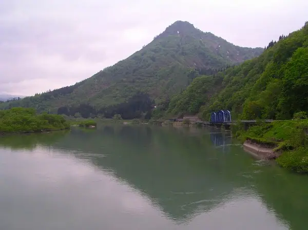
Mount Gamō is an 828 m peak in Tadami, Minamiaizu District, Fukushima Prefecture, rising sharply from the Tadami River like a pyramid and earning the nickname 'Aizu's Matterhorn.' Despite its modest height, the climb features steep slopes, exposed rock crags fitted with chains and ropes, and far-reaching summit views; the trail is maintained each year by villagers from the Gamō hamlet. The mountain lies within Echigo-Sanzan-Tadami Quasi-National Park and appears in many regional renowned-peak lists including the Tōhoku 100 Famous Mountains and the Tadami Four Famous Mountains.
Mount Gamō at a glance
- Weather: The most settled day in the next 7 days is Wed, November 4: clear, gusts up to 7 m/s. Fri, Nov 6, Sat, Nov 7: strong wind (gusts up to 19 m/s).
Mount Gamō weather (hourly, 14 days)
Sunrise today 06:09, sunset 16:44
| Tue, 11/3 | Wed, 11/4 | Thu, 11/5 | Fri, 11/6 | Sat, 11/7 | Sun, 11/8 | Mon, 11/9 | Tue, 11/10 | Wed, 11/11 | Thu, 11/12 | Fri, 11/13 | Sat, 11/14 | Sun, 11/15 | Mon, 11/16 | Tue, 11/17 | |||||||||||||||||||||||||||||||||||||||||||||||||||||||||||||||||||||||
|---|---|---|---|---|---|---|---|---|---|---|---|---|---|---|---|---|---|---|---|---|---|---|---|---|---|---|---|---|---|---|---|---|---|---|---|---|---|---|---|---|---|---|---|---|---|---|---|---|---|---|---|---|---|---|---|---|---|---|---|---|---|---|---|---|---|---|---|---|---|---|---|---|---|---|---|---|---|---|---|---|---|---|---|---|---|
| Japan time | 21 | 23 | 1 | 3 | 5 | 7 | 9 | 11 | 13 | 15 | 17 | 19 | 21 | 0 | 3 | 6 | 9 | 12 | 15 | 18 | 21 | 0 | 3 | 6 | 9 | 12 | 15 | 18 | 21 | 0 | 3 | 6 | 9 | 12 | 15 | 18 | 21 | 0 | 3 | 6 | 9 | 12 | 15 | 18 | 21 | 0 | 3 | 6 | 9 | 12 | 15 | 21 | 3 | 9 | 15 | 21 | 3 | 9 | 15 | 21 | 3 | 9 | 15 | 21 | 3 | 9 | 15 | 21 | 3 | 9 | 15 | 21 | 3 | 9 | 15 | 21 | 3 | 9 | 15 | 21 | 3 | 9 | 15 | 21 | |
 | | |   |   |   |  | | | | | |   |   |   | |   | |   | | |   | | |   | | | | | | | |   | | | | | |   | | | |   | | | | | | | | | | | | | | |   | | | |   | | | | | | | | | |  | | | | | | | | | | | |  | ||
| Temperature | °C | 1° | 0° | 0° | 0° | -1° | 1° | 8° | 11° | 12° | 12° | 7° | 6° | 6° | 6° | 6° | 6° | 9° | 13° | 14° | 9° | 9° | 8° | 8° | 9° | 10° | 11° | 10° | 8° | 6° | 4° | 3° | 3° | 2° | 2° | 1° | 1° | 1° | 1° | 1° | 1° | 2° | 4° | 4° | 2° | 1° | 2° | 2° | 2° | 5° | 10° | 8° | 3° | -1° | 5° | 11° | 5° | 0° | 3° | 4° | 3° | 2° | 4° | 6° | -1° | 3° | 3° | 3° | 1° | 0° | 4° | 9° | -1° | -3° | 7° | 11° | 6° | 6° | 9° | 6° | 1° | 0° | 3° | 5° | 0° |
| Precipitation | mm | 2.7 | 9 | 7 | 3.5 | 0.1 | 0.6 | 0.2 | 3.1 | 1.8 | 1.7 | 1.7 | 1.9 | 1.3 | 3.7 | 3.7 | 3.5 | 6 | 5 | 2.9 | 1.4 | 0.5 | 0.6 | 1.3 | 0.3 | 0.8 | 1.0 | 0.1 | 0.4 | 9 | 5 | 2.2 | 1.3 | 0.2 | 0.3 | 0.2 | 1.9 | 10 | 4.3 | 6 | 2.0 | 4.2 | 3.8 | 0.2 | |||||||||||||||||||||||||||||||||||||||||
| New snow | cm | <.1 | <.1 | <.1 | <.1 | <.1 | 0.1 | 1.4 | 3.3 | ||||||||||||||||||||||||||||||||||||||||||||||||||||||||||||||||||||||||||||
| Snow depth | cm | 0 | 0 | 0 | 0 | 0 | 0 | 0 | 0 | 0 | 0 | 0 | 0 | 0 | 0 | 0 | 0 | 0 | 0 | 0 | 0 | 0 | 0 | 0 | 0 | 0 | 0 | 0 | 0 | 0 | 0 | 0 | 0 | 0 | 0 | 0 | 0 | 0 | 0 | 0 | 0 | 0 | 0 | 0 | 0 | 0 | 0 | 0 | 0 | 0 | 0 | 0 | 0 | 0 | 0 | 0 | 0 | 1 | 1 | <1 | 0 | 0 | 0 | 0 | 0 | 0 | 0 | 0 | 0 | 0 | 0 | 0 | 0 | 0 | 0 | 0 | 0 | 0 | 0 | 0 | 0 | 0 | 0 | 0 | 0 |
| Wind | m/s | 1 | 1 | 1 | 1 | 1 | 1 | 1 | 2 | 2 | 3 | 2 | 2 | 2 | 2 | 2 | 1 | 2 | 2 | 1 | 0 | 1 | 0 | 1 | 3 | 5 | 5 | 6 | 4 | 4 | 4 | 4 | 4 | 3 | 5 | 6 | 5 | 5 | 5 | 5 | 4 | 4 | 4 | 4 | 1 | 1 | 0 | 0 | 0 | 1 | 3 | 3 | 1 | 1 | 1 | 3 | 1 | 2 | 5 | 6 | 2 | 1 | 3 | 3 | 1 | 4 | 3 | 5 | 2 | 1 | 0 | 2 | 0 | 1 | 0 | 1 | 1 | 0 | 1 | 6 | 5 | 3 | 2 | 2 | 0 |
| Wind gusts | m/s | 4 | 4 | 3 | 3 | 3 | 2 | 3 | 5 | 6 | 7 | 7 | 5 | 5 | 5 | 5 | 5 | 5 | 5 | 5 | 2 | 2 | 2 | 4 | 9 | 12 | 15 | 15 | 15 | 13 | 11 | 11 | 14 | 14 | 17 | 19 | 17 | 14 | 13 | 12 | 12 | 11 | 12 | 12 | 9 | 4 | 2 | 2 | 2 | 3 | 7 | 9 | 7 | 3 | 5 | 8 | 7 | 13 | 16 | 18 | 14 | 6 | 7 | 10 | 8 | 11 | 11 | 13 | 11 | 5 | 4 | 5 | 5 | 3 | 3 | 4 | 4 | 3 | 6 | 15 | 15 | 12 | 7 | 6 | 5 |
| Wind dir. | ↓ | ↓ | ↓ | ↓ | ↓ | ↓ | ↓ | ↓ | ↓ | ↓ | ↓ | ↓ | ↓ | ↓ | ↓ | ↓ | ↓ | ↓ | ↓ | ↓ | ↓ | ↓ | ↓ | ↓ | ↓ | ↓ | ↓ | ↓ | ↓ | ↓ | ↓ | ↓ | ↓ | ↓ | ↓ | ↓ | ↓ | ↓ | ↓ | ↓ | ↓ | ↓ | ↓ | ↓ | ↓ | ↓ | ↓ | ↓ | ↓ | ↓ | ↓ | ↓ | ↓ | ↓ | ↓ | ↓ | ↓ | ↓ | ↓ | ↓ | ↓ | ↓ | ↓ | ↓ | ↓ | ↓ | ↓ | ↓ | ↓ | ↓ | ↓ | ↓ | ↓ | ↓ | ↓ | ↓ | ↓ | ↓ | ↓ | ↓ | ↓ | ↓ | ↓ | ↓ | |
Huts, campsites and lodging near Mount Gamō
Lodging
- 民宿いわぶち
- しゃくなげ荘
- ゆの宿 松屋
- 民宿ふる里
- 民宿きよお
Lists that include Mount Gamō
Tohoku 100 Famous Mountains · Utsukushima 100 Famous Mountains (Fukushima Prefecture) · Aizu 100 Famous Mountains · 30 Peaks of Fukushima · 1000 Mountains of Japan
Mount Gamō facts
- Also known as
- 会津のマッターホルン
- Elevation
- 828 m
- Location
- Tadami, Fukushima
37.388538, 139.335512 - National Park
- 越後三山只見国定公園
- Season Opens
- June 1
- Website
- www.tif.ne.jp
- Wikipedia
- ja.wikipedia.org