
Mount Arafune
荒船山
Shimonita, Gunma · Elevation 1,423 m
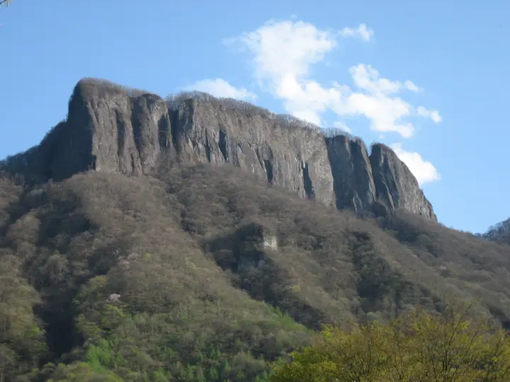
Mount Arafune is a 1,423 m peak spanning Shimonita and Nanmoku in Gunma and Saku in Nagano, named for its distinctive flat-topped silhouette resembling a great ship riding rough seas. Its highest point is Kyōzukayama, and the sheer Tomoiwa cliff at the western end is one of the iconic landscapes of West Jōshū. It lies within Myōgi-Arafune-Sakukōgen Quasi-National Park and is one of the 200 Famous Mountains of Japan.
Mount Arafune at a glance
- Weather: The most settled day in the next 7 days is Mon, November 9: clear, gusts up to 8 m/s. Sat, Nov 7: strong wind (gusts up to 15 m/s).
- Route: The shortest is Mount Arafune, Return from the Arafune Fudo Side to Kyozukayama and the Tomoiwa Lookout: about 4 h, 7.3 km, about 500 m of climbing.
Mount Arafune weather (hourly, 14 days)
Sunrise today 06:09, sunset 16:49
| Tue, 11/3 | Wed, 11/4 | Thu, 11/5 | Fri, 11/6 | Sat, 11/7 | Sun, 11/8 | Mon, 11/9 | Tue, 11/10 | Wed, 11/11 | Thu, 11/12 | Fri, 11/13 | Sat, 11/14 | Sun, 11/15 | Mon, 11/16 | Tue, 11/17 | |||||||||||||||||||||||||||||||||||||||||||||||||||||||||||||||||||||||
|---|---|---|---|---|---|---|---|---|---|---|---|---|---|---|---|---|---|---|---|---|---|---|---|---|---|---|---|---|---|---|---|---|---|---|---|---|---|---|---|---|---|---|---|---|---|---|---|---|---|---|---|---|---|---|---|---|---|---|---|---|---|---|---|---|---|---|---|---|---|---|---|---|---|---|---|---|---|---|---|---|---|---|---|---|---|
| Japan time | 15 | 17 | 19 | 21 | 23 | 1 | 3 | 5 | 7 | 9 | 11 | 13 | 15 | 18 | 21 | 0 | 3 | 6 | 9 | 12 | 15 | 18 | 21 | 0 | 3 | 6 | 9 | 12 | 15 | 18 | 21 | 0 | 3 | 6 | 9 | 12 | 15 | 18 | 21 | 0 | 3 | 6 | 9 | 12 | 15 | 18 | 21 | 0 | 3 | 6 | 9 | 15 | 21 | 3 | 9 | 15 | 21 | 3 | 9 | 15 | 21 | 3 | 9 | 15 | 21 | 3 | 9 | 15 | 21 | 3 | 9 | 15 | 21 | 3 | 9 | 15 | 21 | 3 | 9 | 15 | 21 | 3 | 9 | 15 | |
  |   |  | | | | | | | | | |   |   |   | | | |   |   |   |   | | | | |  | | |  | | | | | | | | | | | | | | | | | | | | | | | | | | | | |   | | | | | | |  | | | | | | | | | | | |   | | | | | | | ||
| Temperature | °C | 10° | 5° | 3° | 2° | 1° | 1° | 1° | 0° | 1° | 7° | 8° | 9° | 7° | 4° | 3° | 3° | 4° | 4° | 7° | 11° | 10° | 7° | 7° | 5° | 5° | 4° | 11° | 16° | 15° | 8° | 4° | 4° | 3° | 3° | 6° | 7° | 5° | 2° | -1° | -3° | -4° | -5° | 2° | 8° | 7° | 2° | 0° | 0° | -1° | -1° | 3° | 5° | 1° | 1° | 2° | 3° | 0° | -1° | 2° | 4° | 0° | -3° | 3° | 6° | -1° | -3° | 4° | 5° | -3° | -5° | 2° | 5° | -2° | -3° | 4° | 8° | 3° | 3° | 10° | 11° | 2° | -2° | 1° | 4° |
| Precipitation | mm | 0.3 | 1.8 | 9 | 6 | 0.5 | 0.5 | 0.4 | 0.3 | 0.2 | 0.1 | 4.4 | 8 | 0.1 | |||||||||||||||||||||||||||||||||||||||||||||||||||||||||||||||||||||||
| New snow | cm | <.1 | |||||||||||||||||||||||||||||||||||||||||||||||||||||||||||||||||||||||||||||||||||
| Snow depth | cm | 0 | 0 | 0 | 0 | 0 | 0 | 0 | 0 | 0 | 0 | 0 | 0 | 0 | 0 | 0 | 0 | 0 | 0 | 0 | 0 | 0 | 0 | 0 | 0 | 0 | 0 | 0 | 0 | 0 | 0 | 0 | 0 | 0 | 0 | 0 | 0 | 0 | 0 | 0 | 0 | 0 | 0 | 0 | 0 | 0 | 0 | 0 | 0 | 0 | 0 | 0 | 0 | 0 | 0 | 0 | 0 | 0 | 0 | 0 | 0 | 0 | 0 | 0 | 0 | 0 | 0 | 0 | 0 | 0 | 0 | 0 | 0 | 0 | 0 | 0 | 0 | 0 | 0 | 0 | 0 | 0 | 0 | 0 | 0 |
| Wind | m/s | 1 | 1 | 0 | 1 | 1 | 0 | 0 | 1 | 1 | 1 | 3 | 4 | 4 | 2 | 2 | 1 | 1 | 0 | 1 | 1 | 1 | 1 | 1 | 0 | 1 | 2 | 2 | 5 | 4 | 1 | 3 | 4 | 3 | 3 | 5 | 6 | 6 | 3 | 2 | 1 | 2 | 2 | 2 | 2 | 1 | 1 | 1 | 0 | 1 | 1 | 1 | 2 | 1 | 2 | 2 | 3 | 1 | 3 | 7 | 5 | 4 | 2 | 1 | 3 | 1 | 2 | 3 | 5 | 3 | 2 | 1 | 2 | 0 | 0 | 1 | 2 | 0 | 0 | 2 | 4 | 3 | 3 | 2 | 3 |
| Wind gusts | m/s | 8 | 6 | 2 | 2 | 2 | 2 | 2 | 2 | 3 | 4 | 7 | 10 | 11 | 10 | 6 | 4 | 4 | 3 | 3 | 4 | 4 | 3 | 3 | 3 | 4 | 6 | 7 | 12 | 13 | 11 | 7 | 10 | 10 | 10 | 13 | 15 | 15 | 14 | 9 | 5 | 5 | 5 | 7 | 8 | 8 | 5 | 4 | 3 | 3 | 4 | 4 | 8 | 6 | 4 | 6 | 8 | 7 | 9 | 20 | 18 | 12 | 9 | 6 | 7 | 7 | 5 | 9 | 13 | 12 | 7 | 6 | 7 | 5 | 2 | 3 | 6 | 4 | 4 | 6 | 13 | 12 | 12 | 8 | 7 |
| Wind dir. | ↓ | ↓ | ↓ | ↓ | ↓ | ↓ | ↓ | ↓ | ↓ | ↓ | ↓ | ↓ | ↓ | ↓ | ↓ | ↓ | ↓ | ↓ | ↓ | ↓ | ↓ | ↓ | ↓ | ↓ | ↓ | ↓ | ↓ | ↓ | ↓ | ↓ | ↓ | ↓ | ↓ | ↓ | ↓ | ↓ | ↓ | ↓ | ↓ | ↓ | ↓ | ↓ | ↓ | ↓ | ↓ | ↓ | ↓ | ↓ | ↓ | ↓ | ↓ | ↓ | ↓ | ↓ | ↓ | ↓ | ↓ | ↓ | ↓ | ↓ | ↓ | ↓ | ↓ | ↓ | ↓ | ↓ | ↓ | ↓ | ↓ | ↓ | ↓ | ↓ | ↓ | ↓ | ↓ | ↓ | ↓ | ↓ | ↓ | ↓ | ↓ | ↓ | ↓ | ↓ | |
Mount Arafune hiking routes
- Mount Arafune, Return from the Arafune Fudo Side to Kyozukayama and the Tomoiwa Lookout 7.3 km · Ascent 503 m parking
- Mount Arafune from Uchiyama Pass via Tomoiwa 9.6 km · Ascent 643 m 荒船山 登山口 (parking)
Hiking times are estimates calculated from the terrain.
Huts, campsites and lodging near Mount Arafune
Campsites
- Arafune Panorama Campfield
Lodging
- 体験型古民家民宿 かじか倶楽部
Lists that include Mount Arafune
Japan 200 Famous Mountains · Japan's 300 Famous Mountains · New Japan 100 Famous Mountains · 100 Low Mountains of Japan · Kanto 100 Famous Mountains · Shinshu 100 Famous Mountains · Gunma 100 Famous Mountains · Mountain Walking in Shimonita · Elevations of 1003 Mountains of Japan · 1000 Mountains of Japan
Mount Arafune facts
- Also known as
- 経塚山 · 行塚山
- Elevation
- 1,423 m
- Location
- Shimonita, Gunma
36.204031, 138.637129 - National Park
- 妙義荒船佐久高原国定公園
- Website
- www.town.shimonita.lg.jp
- Trail Map
- www.town.shimonita.lg.jp (PDF)
- Wikipedia
- ja.wikipedia.org