
Mount Arafune
荒船山
Saku, Nagano · Elevation 1,337 m
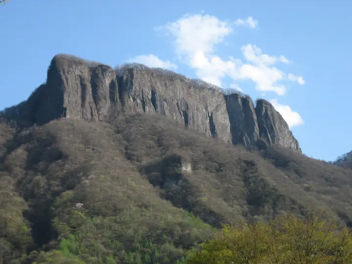
Mount Arafune is known for its ship-like outline, flat summit plateau and sheer cliffs. Tomoiwa lookout is about a 90-minute walk from Uchiyama Pass, with rocky sections equipped with chains and ropes along the way. The lookout offers views of Mount Asama, Myogi and Kozu Farm.
Mount Arafune at a glance
- Weather: The most settled day in the next 7 days is Mon, November 9: clear, gusts up to 8 m/s. Sat, Nov 7: strong wind (gusts up to 15 m/s).
- Route: The shortest is Mount Arafune, Return from the Arafune Fudo Side to Kyozukayama and the Tomoiwa Lookout: about 4 h, 7.3 km, about 500 m of climbing.
Mount Arafune weather (hourly, 14 days)
Sunrise today 06:09, sunset 16:49
| Tue, 11/3 | Wed, 11/4 | Thu, 11/5 | Fri, 11/6 | Sat, 11/7 | Sun, 11/8 | Mon, 11/9 | Tue, 11/10 | Wed, 11/11 | Thu, 11/12 | Fri, 11/13 | Sat, 11/14 | Sun, 11/15 | Mon, 11/16 | Tue, 11/17 | |||||||||||||||||||||||||||||||||||||||||||||||||||||||||||||||||||||||
|---|---|---|---|---|---|---|---|---|---|---|---|---|---|---|---|---|---|---|---|---|---|---|---|---|---|---|---|---|---|---|---|---|---|---|---|---|---|---|---|---|---|---|---|---|---|---|---|---|---|---|---|---|---|---|---|---|---|---|---|---|---|---|---|---|---|---|---|---|---|---|---|---|---|---|---|---|---|---|---|---|---|---|---|---|---|
| Japan time | 15 | 17 | 19 | 21 | 23 | 1 | 3 | 5 | 7 | 9 | 11 | 13 | 15 | 18 | 21 | 0 | 3 | 6 | 9 | 12 | 15 | 18 | 21 | 0 | 3 | 6 | 9 | 12 | 15 | 18 | 21 | 0 | 3 | 6 | 9 | 12 | 15 | 18 | 21 | 0 | 3 | 6 | 9 | 12 | 15 | 18 | 21 | 0 | 3 | 6 | 9 | 15 | 21 | 3 | 9 | 15 | 21 | 3 | 9 | 15 | 21 | 3 | 9 | 15 | 21 | 3 | 9 | 15 | 21 | 3 | 9 | 15 | 21 | 3 | 9 | 15 | 21 | 3 | 9 | 15 | 21 | 3 | 9 | 15 | |
  |   |  | | | | | | | | | |   |   |   | | | |   |   |   |   | | | | |  | | |  | | | | | | | | | | | | | | | | | | | | | | | | | | | | |   | | | | | | |  | | | | | | | | | | | |   | | | | | | | ||
| Temperature | °C | 11° | 5° | 4° | 2° | 2° | 2° | 1° | 1° | 2° | 7° | 9° | 9° | 8° | 5° | 4° | 4° | 4° | 4° | 8° | 12° | 11° | 7° | 7° | 6° | 5° | 5° | 12° | 17° | 16° | 9° | 5° | 5° | 3° | 3° | 6° | 7° | 6° | 2° | 0° | -2° | -3° | -4° | 3° | 8° | 8° | 2° | 0° | 0° | 0° | 0° | 3° | 5° | 2° | 1° | 3° | 4° | 1° | -1° | 2° | 4° | 0° | -3° | 3° | 7° | -1° | -2° | 5° | 5° | -2° | -5° | 3° | 6° | -1° | -2° | 4° | 8° | 4° | 4° | 11° | 12° | 2° | -2° | 2° | 5° |
| Precipitation | mm | 0.3 | 1.8 | 9 | 6 | 0.5 | 0.5 | 0.4 | 0.3 | 0.2 | 0.1 | 4.4 | 8 | 0.1 | |||||||||||||||||||||||||||||||||||||||||||||||||||||||||||||||||||||||
| New snow | cm | <.1 | |||||||||||||||||||||||||||||||||||||||||||||||||||||||||||||||||||||||||||||||||||
| Snow depth | cm | 0 | 0 | 0 | 0 | 0 | 0 | 0 | 0 | 0 | 0 | 0 | 0 | 0 | 0 | 0 | 0 | 0 | 0 | 0 | 0 | 0 | 0 | 0 | 0 | 0 | 0 | 0 | 0 | 0 | 0 | 0 | 0 | 0 | 0 | 0 | 0 | 0 | 0 | 0 | 0 | 0 | 0 | 0 | 0 | 0 | 0 | 0 | 0 | 0 | 0 | 0 | 0 | 0 | 0 | 0 | 0 | 0 | 0 | 0 | 0 | 0 | 0 | 0 | 0 | 0 | 0 | 0 | 0 | 0 | 0 | 0 | 0 | 0 | 0 | 0 | 0 | 0 | 0 | 0 | 0 | 0 | 0 | 0 | 0 |
| Wind | m/s | 1 | 1 | 0 | 1 | 1 | 0 | 0 | 1 | 1 | 1 | 3 | 4 | 4 | 2 | 2 | 1 | 1 | 0 | 1 | 1 | 1 | 1 | 1 | 0 | 1 | 2 | 2 | 5 | 4 | 1 | 3 | 4 | 3 | 3 | 5 | 6 | 6 | 3 | 2 | 1 | 2 | 2 | 2 | 2 | 1 | 1 | 1 | 0 | 1 | 1 | 1 | 2 | 1 | 2 | 2 | 3 | 1 | 3 | 7 | 5 | 4 | 2 | 1 | 3 | 1 | 2 | 3 | 5 | 3 | 2 | 1 | 2 | 0 | 0 | 1 | 2 | 0 | 0 | 2 | 4 | 3 | 3 | 2 | 3 |
| Wind gusts | m/s | 8 | 6 | 2 | 2 | 2 | 2 | 2 | 2 | 3 | 4 | 7 | 10 | 11 | 10 | 6 | 4 | 4 | 3 | 3 | 4 | 4 | 3 | 3 | 3 | 4 | 6 | 7 | 12 | 13 | 11 | 7 | 10 | 10 | 10 | 13 | 15 | 15 | 14 | 9 | 5 | 5 | 5 | 7 | 8 | 8 | 5 | 4 | 3 | 3 | 4 | 4 | 8 | 6 | 4 | 6 | 8 | 7 | 9 | 20 | 18 | 12 | 9 | 6 | 7 | 7 | 5 | 9 | 13 | 12 | 7 | 6 | 7 | 5 | 2 | 3 | 6 | 4 | 4 | 6 | 13 | 12 | 12 | 8 | 7 |
| Wind dir. | ↓ | ↓ | ↓ | ↓ | ↓ | ↓ | ↓ | ↓ | ↓ | ↓ | ↓ | ↓ | ↓ | ↓ | ↓ | ↓ | ↓ | ↓ | ↓ | ↓ | ↓ | ↓ | ↓ | ↓ | ↓ | ↓ | ↓ | ↓ | ↓ | ↓ | ↓ | ↓ | ↓ | ↓ | ↓ | ↓ | ↓ | ↓ | ↓ | ↓ | ↓ | ↓ | ↓ | ↓ | ↓ | ↓ | ↓ | ↓ | ↓ | ↓ | ↓ | ↓ | ↓ | ↓ | ↓ | ↓ | ↓ | ↓ | ↓ | ↓ | ↓ | ↓ | ↓ | ↓ | ↓ | ↓ | ↓ | ↓ | ↓ | ↓ | ↓ | ↓ | ↓ | ↓ | ↓ | ↓ | ↓ | ↓ | ↓ | ↓ | ↓ | ↓ | ↓ | ↓ | |
Mount Arafune hiking routes
- Mount Arafune, Return from the Arafune Fudo Side to Kyozukayama and the Tomoiwa Lookout 7.3 km · Ascent 503 m parking
- Mount Arafune from Uchiyama Pass via Tomoiwa 9.6 km · Ascent 643 m 荒船山 登山口 (parking)
Hiking times are estimates calculated from the terrain.
Huts, campsites and lodging near Mount Arafune
Campsites
- Arafune Panorama Campfield
Lodging
- 体験型古民家民宿 かじか倶楽部
Mount Arafune facts
- Elevation
- 1,337 m
- Location
- Saku, Nagano
36.208840, 138.634474 - Website
- www.city.saku.nagano.jp
- Trail Map
- www.town.shimonita.lg.jp (PDF)
- Wikipedia
- ja.wikipedia.org