
Toma-no-Mimi
谷川岳 トマノ耳
Minakami, Gunma · Elevation 1,963 m
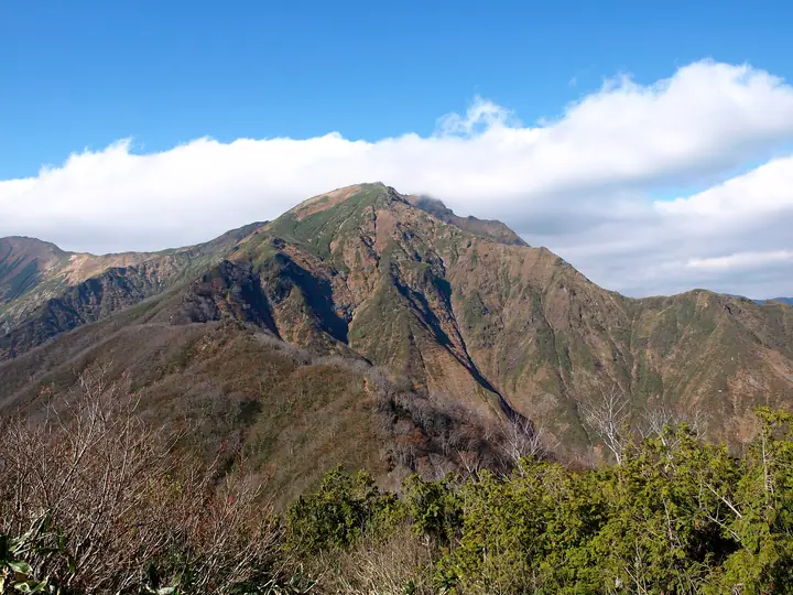
Toma-no-Mimi (Yakushi-dake, 1,963 m) is the southwestern of the twin peaks that together form Mount Tanigawa, paired with the slightly higher Oki-no-Mimi (1,977 m) to the northeast. Straddling Minakami Town in Gunma and Yuzawa Town in Niigata, it lies within Jōshin'etsu-Kōgen National Park. It sits on the standard Tenjin-One ridge route from the Tanigawadake Joch ropeway via Kata-no-Goya, and is usually visited together with Oki-no-Mimi.
Toma-no-Mimi at a glance
- Weather: The most settled day in the next 7 days is Wed, November 4: clear, gusts up to 10 m/s. Sat, Nov 7, Sun, Nov 8: strong wind (gusts up to 19 m/s).
- Route: The shortest is Mount Tanigawa Nishiguro Ridge Ascent and Tenjin Ridge Descent: about 5 h 57 min, 8.1 km, about 1,320 m of climbing.
Toma-no-Mimi weather (hourly, 14 days)
Sunrise today 06:09, sunset 16:47
| Tue, 11/3 | Wed, 11/4 | Thu, 11/5 | Fri, 11/6 | Sat, 11/7 | Sun, 11/8 | Mon, 11/9 | Tue, 11/10 | Wed, 11/11 | Thu, 11/12 | Fri, 11/13 | Sat, 11/14 | Sun, 11/15 | Mon, 11/16 | Tue, 11/17 | |||||||||||||||||||||||||||||||||||||||||||||||||||||||||||||||||||||||
|---|---|---|---|---|---|---|---|---|---|---|---|---|---|---|---|---|---|---|---|---|---|---|---|---|---|---|---|---|---|---|---|---|---|---|---|---|---|---|---|---|---|---|---|---|---|---|---|---|---|---|---|---|---|---|---|---|---|---|---|---|---|---|---|---|---|---|---|---|---|---|---|---|---|---|---|---|---|---|---|---|---|---|---|---|---|
| Japan time | 15 | 17 | 19 | 21 | 23 | 1 | 3 | 5 | 7 | 9 | 11 | 13 | 15 | 18 | 21 | 0 | 3 | 6 | 9 | 12 | 15 | 18 | 21 | 0 | 3 | 6 | 9 | 12 | 15 | 18 | 21 | 0 | 3 | 6 | 9 | 12 | 15 | 18 | 21 | 0 | 3 | 6 | 9 | 12 | 15 | 18 | 21 | 0 | 3 | 6 | 9 | 15 | 21 | 3 | 9 | 15 | 21 | 3 | 9 | 15 | 21 | 3 | 9 | 15 | 21 | 3 | 9 | 15 | 21 | 3 | 9 | 15 | 21 | 3 | 9 | 15 | 21 | 3 | 9 | 15 | 21 | 3 | 9 | 15 | |
  |   | | | | | | |  | | | |   |   |   | | | | |   | |   | | | | | | | | | | | |   |   | | | | |   | | |   | | | | | | | | | | | |   | | | | | | | | | | | | | | | | | |  | | |   | |   | | | | | | | ||
| Temperature | °C | 2° | 0° | -2° | -2° | -3° | -3° | -3° | -3° | -1° | 4° | 6° | 7° | 5° | 1° | 0° | 0° | 1° | 2° | 4° | 9° | 9° | 5° | 4° | 4° | 3° | 4° | 6° | 6° | 6° | 3° | 1° | 0° | -2° | -3° | -3° | -3° | -3° | -4° | -4° | -5° | -5° | -4° | -2° | -1° | -2° | -4° | -5° | -4° | -3° | -4° | 0° | 0° | -3° | -3° | 0° | 0° | -2° | -5° | -4° | -4° | -4° | -4° | -2° | -1° | -5° | -3° | -4° | -4° | -5° | -6° | 0° | 3° | -5° | -5° | 2° | 3° | 0° | 1° | 4° | 1° | -4° | -6° | -3° | 0° |
| Precipitation | mm | 0.1 | 0.2 | 0.3 | 10 | 7 | 0.9 | 1.3 | 0.2 | 0.3 | 1.0 | 0.4 | 0.4 | 1.3 | 2.1 | 1.0 | 0.6 | 1.8 | 1.8 | 1.6 | 1.1 | 0.8 | 0.7 | 0.2 | 0.2 | 0.1 | 0.2 | 0.4 | 0.3 | 0.1 | 0.2 | 0.6 | 0.2 | 0.2 | 5 | 3.5 | 9 | 4.0 | 1.6 | 9 | 3.8 | 1.2 | 0.2 | 4.2 | 5 | 0.2 | 7 | 12 | 3.0 | ||||||||||||||||||||||||||||||||||||
| New snow | cm | <.1 | 1.0 | 1.2 | 1.2 | 0.9 | 0.6 | 0.6 | 0.2 | 0.2 | <.1 | <.1 | <.1 | <.1 | <.1 | 4.3 | 3.3 | 6.2 | 1.4 | 0.6 | 6.2 | 3.2 | 1.0 | <.1 | 2.0 | 2.1 | |||||||||||||||||||||||||||||||||||||||||||||||||||||||||||
| Snow depth | cm | 0 | 0 | 0 | 0 | 0 | 0 | 0 | 0 | 0 | 0 | 0 | 0 | 0 | 0 | 0 | 0 | 0 | 0 | 0 | 0 | 0 | 0 | 0 | 0 | 0 | 0 | 0 | 0 | 0 | 0 | 0 | 0 | 0 | 0 | <1 | 1 | 1 | 1 | 2 | 2 | 2 | 2 | 2 | 2 | 2 | 1 | 1 | 1 | 1 | 1 | 1 | <1 | <1 | <1 | <1 | <1 | 0 | 3 | 5 | 6 | 7 | 6 | 5 | 3 | 3 | 3 | 6 | 7 | 7 | 7 | 7 | 5 | 5 | 5 | 5 | 3 | 2 | 2 | 1 | <1 | 1 | 2 | 2 | 1 |
| Wind | m/s | 4 | 3 | 2 | 2 | 2 | 2 | 2 | 2 | 2 | 1 | 1 | 3 | 3 | 4 | 3 | 4 | 2 | 1 | 1 | 1 | 1 | 1 | 0 | 1 | 2 | 2 | 3 | 4 | 3 | 4 | 4 | 5 | 5 | 5 | 5 | 6 | 5 | 6 | 5 | 4 | 5 | 4 | 4 | 5 | 4 | 2 | 2 | 2 | 2 | 2 | 1 | 3 | 2 | 1 | 3 | 3 | 2 | 3 | 8 | 8 | 4 | 2 | 2 | 2 | 1 | 3 | 3 | 6 | 4 | 2 | 1 | 1 | 1 | 0 | 1 | 1 | 1 | 1 | 2 | 7 | 7 | 4 | 2 | 2 |
| Wind gusts | m/s | 14 | 12 | 8 | 6 | 5 | 5 | 6 | 5 | 5 | 5 | 6 | 8 | 10 | 12 | 12 | 13 | 12 | 9 | 7 | 5 | 5 | 4 | 4 | 3 | 5 | 8 | 10 | 11 | 11 | 10 | 13 | 16 | 17 | 18 | 17 | 19 | 19 | 19 | 18 | 16 | 17 | 17 | 14 | 15 | 16 | 13 | 6 | 6 | 5 | 6 | 5 | 9 | 9 | 6 | 8 | 11 | 10 | 10 | 28 | 28 | 25 | 12 | 8 | 9 | 8 | 8 | 10 | 20 | 20 | 13 | 8 | 5 | 5 | 4 | 5 | 6 | 7 | 8 | 8 | 20 | 22 | 21 | 11 | 7 |
| Wind dir. | ↓ | ↓ | ↓ | ↓ | ↓ | ↓ | ↓ | ↓ | ↓ | ↓ | ↓ | ↓ | ↓ | ↓ | ↓ | ↓ | ↓ | ↓ | ↓ | ↓ | ↓ | ↓ | ↓ | ↓ | ↓ | ↓ | ↓ | ↓ | ↓ | ↓ | ↓ | ↓ | ↓ | ↓ | ↓ | ↓ | ↓ | ↓ | ↓ | ↓ | ↓ | ↓ | ↓ | ↓ | ↓ | ↓ | ↓ | ↓ | ↓ | ↓ | ↓ | ↓ | ↓ | ↓ | ↓ | ↓ | ↓ | ↓ | ↓ | ↓ | ↓ | ↓ | ↓ | ↓ | ↓ | ↓ | ↓ | ↓ | ↓ | ↓ | ↓ | ↓ | ↓ | ↓ | ↓ | ↓ | ↓ | ↓ | ↓ | ↓ | ↓ | ↓ | ↓ | ↓ | |
Toma-no-Mimi hiking routes
- Mount Tanigawa Nishiguro Ridge Ascent and Tenjin Ridge Descent 8.1 km · Ascent 1,324 m Tanigawadake Yoch (Bus stop), 土合口 (Aerialway station) (parking) → 天神平 (Aerialway station)
- Joetsu Border Steep Nishiguro Ridge over the Twin Summits of Tanigawa and down the Shigekura Trail to Tsuchitaru 14.6 km · Ascent 1,565 m Doaibashi (Bus stop) (parking) → 土樽駅 (Station), Tsuchitaru (Station)
Hiking times are estimates calculated from the terrain.
Huts, campsites and lodging near Toma-no-Mimi
Mountain huts
- Tanigawadake Kata no Koya 2026: open June 1–November 3 · reservation required
- 熊穴沢避難小屋 unstaffed
- 一ノ倉岳避難小屋 unstaffed · sleeps 2
- オジカ沢ノ頭避難小屋 unstaffed · sleeps 4
- 茂倉岳避難小屋 unstaffed · sleeps 20
Lodging
- Tenjin Lodge
Toma-no-Mimi facts
- Also known as
- 谷川岳 · 薬師岳
- Elevation
- 1,963 m
- Location
- Minakami, Gunma
36.834393, 138.930214 - National Park
- 上信越高原国立公園
- Season Opens
- July 1
- Season Closes
- October 31
- Website
- www.enjoy-minakami.jp
- Trail Map
- www.enjoy-minakami.jp (PDF)
- Access Information
- tanigawadake-joch.com
- Wikipedia
- ja.wikipedia.org