
Mt. Waita
涌蓋山
Kokonoe, Oita · Elevation 1,499 m
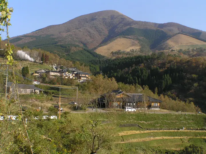
Mt. Waita (1,500 m) is a graceful conical volcano on the border of Kokonoe Town in Ōita and Oguni Town in Kumamoto, marking the western end of the Kuju Range and known locally as "Kusu Fuji" or "Oguni Fuji." Its lower slopes lie in one of Japan's foremost geothermal zones, ringed by the Sujiyu, Hagenoyu, and Waita hot-spring villages, making it a favourite for combining a hike with an onsen visit. The summit commands 360-degree views over the Kuju Range and Mt. Aso, with Miyamakirishima azaleas in June and golden grass in autumn. It is counted among Japan's 300 Famous Mountains, the 100 Famous Mountains of Kyūshū, the 100 Hot-Spring Mountains, and the 100 Fujis of Japan.
Mt. Waita at a glance
- Weather: The most settled day in the next 7 days is Sun, November 8: cloudy, gusts up to 4 m/s.
- Route: The shortest is Mount Waita Return from Hage no Yu: about 3 h 18 min, 5.1 km, about 660 m of climbing.
Mt. Waita weather (hourly, 14 days)
Sunrise today 06:35, sunset 17:23
| Tue, 11/3 | Wed, 11/4 | Thu, 11/5 | Fri, 11/6 | Sat, 11/7 | Sun, 11/8 | Mon, 11/9 | Tue, 11/10 | Wed, 11/11 | Thu, 11/12 | Fri, 11/13 | Sat, 11/14 | Sun, 11/15 | Mon, 11/16 | Tue, 11/17 | |||||||||||||||||||||||||||||||||||||||||||||||||||||||||||||||||||||||
|---|---|---|---|---|---|---|---|---|---|---|---|---|---|---|---|---|---|---|---|---|---|---|---|---|---|---|---|---|---|---|---|---|---|---|---|---|---|---|---|---|---|---|---|---|---|---|---|---|---|---|---|---|---|---|---|---|---|---|---|---|---|---|---|---|---|---|---|---|---|---|---|---|---|---|---|---|---|---|---|---|---|---|---|---|---|
| Japan time | 15 | 17 | 19 | 21 | 23 | 1 | 3 | 5 | 7 | 9 | 11 | 13 | 15 | 18 | 21 | 0 | 3 | 6 | 9 | 12 | 15 | 18 | 21 | 0 | 3 | 6 | 9 | 12 | 15 | 18 | 21 | 0 | 3 | 6 | 9 | 12 | 15 | 18 | 21 | 0 | 3 | 6 | 9 | 12 | 15 | 18 | 21 | 0 | 3 | 6 | 9 | 15 | 21 | 3 | 9 | 15 | 21 | 3 | 9 | 15 | 21 | 3 | 9 | 15 | 21 | 3 | 9 | 15 | 21 | 3 | 9 | 15 | 21 | 3 | 9 | 15 | 21 | 3 | 9 | 15 | 21 | 3 | 9 | 15 | |
  |   |   | |   | | | | | | | | |   | | |   | |  |   |   |   | | | | |   | | |  | | | | | | | | | | | | | | | | | | | | | | | | | | |   | | | | | | | |  | | | | | | | | | |   | | | | | | | | | | ||
| Temperature | °C | 9° | 7° | 5° | 5° | 2° | 3° | 4° | 3° | 4° | 6° | 10° | 12° | 12° | 8° | 8° | 7° | 7° | 6° | 11° | 13° | 12° | 11° | 11° | 9° | 8° | 6° | 7° | 9° | 8° | 2° | 1° | 0° | -2° | -2° | 1° | 5° | 5° | 0° | -2° | -3° | -3° | -2° | 5° | 8° | 8° | 5° | 4° | 4° | 4° | 3° | 5° | 7° | 2° | 0° | 3° | 6° | 0° | 0° | 1° | 4° | -2° | -1° | 3° | 6° | 0° | -1° | 5° | 8° | 0° | 0° | 5° | 11° | 4° | 7° | 10° | 10° | 8° | 8° | 7° | 10° | 4° | 4° | 4° | 8° |
| Precipitation | mm | 1.7 | 1.6 | 3.4 | 2.2 | 0.8 | 0.6 | 0.6 | 0.4 | 0.1 | 0.3 | 0.2 | 0.1 | 0.5 | 3.0 | 2.4 | 0.5 | 0.7 | 0.7 | 0.1 | |||||||||||||||||||||||||||||||||||||||||||||||||||||||||||||||||
| New snow | cm | ||||||||||||||||||||||||||||||||||||||||||||||||||||||||||||||||||||||||||||||||||||
| Snow depth | cm | 0 | 0 | 0 | 0 | 0 | 0 | 0 | 0 | 0 | 0 | 0 | 0 | 0 | 0 | 0 | 0 | 0 | 0 | 0 | 0 | 0 | 0 | 0 | 0 | 0 | 0 | 0 | 0 | 0 | 0 | 0 | 0 | 0 | 0 | 0 | 0 | 0 | 0 | 0 | 0 | 0 | 0 | 0 | 0 | 0 | 0 | 0 | 0 | 0 | 0 | 0 | 0 | 0 | 0 | 0 | 0 | 0 | 0 | 0 | 0 | 0 | 0 | 0 | 0 | 0 | 0 | 0 | 0 | 0 | 0 | 0 | 0 | 0 | 0 | 0 | 0 | 0 | 0 | 0 | 0 | 0 | 0 | 0 | 0 |
| Wind | m/s | 3 | 2 | 2 | 2 | 1 | 1 | 1 | 1 | 1 | 2 | 3 | 2 | 2 | 1 | 2 | 1 | 1 | 2 | 2 | 4 | 5 | 3 | 4 | 5 | 5 | 4 | 5 | 6 | 5 | 4 | 4 | 4 | 4 | 4 | 4 | 4 | 3 | 1 | 1 | 1 | 1 | 1 | 1 | 1 | 1 | 0 | 1 | 1 | 1 | 1 | 3 | 3 | 1 | 0 | 3 | 5 | 3 | 3 | 4 | 3 | 1 | 0 | 1 | 2 | 0 | 2 | 3 | 2 | 1 | 2 | 2 | 1 | 2 | 3 | 6 | 2 | 1 | 3 | 4 | 4 | 1 | 2 | 1 | 3 |
| Wind gusts | m/s | 8 | 8 | 6 | 6 | 5 | 3 | 3 | 3 | 4 | 5 | 7 | 7 | 6 | 5 | 6 | 5 | 4 | 4 | 6 | 11 | 14 | 13 | 10 | 11 | 12 | 13 | 11 | 14 | 14 | 13 | 11 | 11 | 12 | 11 | 11 | 12 | 10 | 8 | 4 | 3 | 2 | 3 | 4 | 4 | 4 | 3 | 3 | 4 | 4 | 4 | 7 | 9 | 8 | 4 | 8 | 12 | 12 | 9 | 11 | 11 | 8 | 2 | 3 | 6 | 6 | 5 | 8 | 9 | 6 | 4 | 5 | 7 | 6 | 9 | 15 | 15 | 9 | 7 | 9 | 11 | 10 | 5 | 4 | 8 |
| Wind dir. | ↓ | ↓ | ↓ | ↓ | ↓ | ↓ | ↓ | ↓ | ↓ | ↓ | ↓ | ↓ | ↓ | ↓ | ↓ | ↓ | ↓ | ↓ | ↓ | ↓ | ↓ | ↓ | ↓ | ↓ | ↓ | ↓ | ↓ | ↓ | ↓ | ↓ | ↓ | ↓ | ↓ | ↓ | ↓ | ↓ | ↓ | ↓ | ↓ | ↓ | ↓ | ↓ | ↓ | ↓ | ↓ | ↓ | ↓ | ↓ | ↓ | ↓ | ↓ | ↓ | ↓ | ↓ | ↓ | ↓ | ↓ | ↓ | ↓ | ↓ | ↓ | ↓ | ↓ | ↓ | ↓ | ↓ | ↓ | ↓ | ↓ | ↓ | ↓ | ↓ | ↓ | ↓ | ↓ | ↓ | ↓ | ↓ | ↓ | ↓ | ↓ | ↓ | ↓ | ↓ | |
Mt. Waita hiking routes
- Mount Waita Return from Hage no Yu 5.1 km · Ascent 656 m parking
- Mount Waita Return via Mount Hitome and Mount Misokobushi 11.6 km · Ascent 753 m
Hiking times are estimates calculated from the terrain.
Huts, campsites and lodging near Mt. Waita
Lodging
- 旅館 自滝
- 九重悠々亭
- Kokonoe
- 大黒屋
Lists that include Mt. Waita
Japan's 300 Famous Mountains · 100 Famous Hot Spring Mountains · 100 Fujis of Japan · Kyushu 100 Famous Mountains · Oita 100 Mountains · Kumamoto 100 Famous Mountains · Elevations of 1003 Mountains of Japan · 1000 Mountains of Japan
Mt. Waita facts
- Also known as
- 玖珠富士 · 小国富士 · 湧蓋山
- Elevation
- 1,499 m
- Location
- Kokonoe, Oita
33.139945, 131.164457 - Website
- oita-osoto.jp
- Wikipedia
- ja.wikipedia.org