
Mt. Ningyouzan
人形山
Nanto, Toyama · Elevation 1,726 m
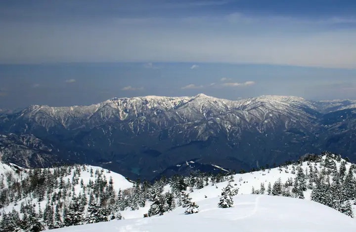
Mt. Ningyouzan (1,726 m) sits on the border between Gokayama in Nanto City (Toyama) and Shirakawa Village (Gifu), in the northern part of the Hida Highlands. Its name — meaning "doll mountain" — comes from a snow-melt pattern resembling two girls holding hands that appears on the western slope each June, and the peak has long been associated with the Hakusan ascetic tradition founded by the monk Taicho. It is included in Japan's 300 Famous Mountains, the New 100 Famous Mountains of Japan, and the 100 Mountains of Gifu. The standard climb begins at the Nakane trailhead on the Toyama side, and an annual yamabiraki (mountain-opening) ceremony is held on the first Sunday of June.
Mt. Ningyouzan at a glance
- Weather: The most settled day in the next 7 days is Wed, November 4: clear, gusts up to 6 m/s.
Mt. Ningyouzan weather (hourly, 14 days)
Sunrise today 06:16, sunset 16:55
| Tue, 11/3 | Wed, 11/4 | Thu, 11/5 | Fri, 11/6 | Sat, 11/7 | Sun, 11/8 | Mon, 11/9 | Tue, 11/10 | Wed, 11/11 | Thu, 11/12 | Fri, 11/13 | Sat, 11/14 | Sun, 11/15 | Mon, 11/16 | Tue, 11/17 | |||||||||||||||||||||||||||||||||||||||||||||||||||||||||||||||||||||||
|---|---|---|---|---|---|---|---|---|---|---|---|---|---|---|---|---|---|---|---|---|---|---|---|---|---|---|---|---|---|---|---|---|---|---|---|---|---|---|---|---|---|---|---|---|---|---|---|---|---|---|---|---|---|---|---|---|---|---|---|---|---|---|---|---|---|---|---|---|---|---|---|---|---|---|---|---|---|---|---|---|---|---|---|---|---|
| Japan time | 15 | 17 | 19 | 21 | 23 | 1 | 3 | 5 | 7 | 9 | 11 | 13 | 15 | 18 | 21 | 0 | 3 | 6 | 9 | 12 | 15 | 18 | 21 | 0 | 3 | 6 | 9 | 12 | 15 | 18 | 21 | 0 | 3 | 6 | 9 | 12 | 15 | 18 | 21 | 0 | 3 | 6 | 9 | 12 | 15 | 18 | 21 | 0 | 3 | 6 | 9 | 15 | 21 | 3 | 9 | 15 | 21 | 3 | 9 | 15 | 21 | 3 | 9 | 15 | 21 | 3 | 9 | 15 | 21 | 3 | 9 | 15 | 21 | 3 | 9 | 15 | 21 | 3 | 9 | 15 | 21 | 3 | 9 | 15 | |
  |   | |  | | | | |   |  | | | |   |   |   | | |   |   | | |   | | | | |   | | | | | |   |   | | | | | | | | | | | | | | | | | | | | | |   | |   | | | | |   | | | | | | | | | | | | | | | | | | | | | ||
| Temperature | °C | 6° | 2° | 0° | -1° | -1° | -1° | -2° | -2° | -3° | 4° | 8° | 10° | 9° | 5° | 5° | 4° | 4° | 4° | 5° | 10° | 12° | 7° | 7° | 5° | 5° | 6° | 6° | 9° | 5° | 3° | 1° | 0° | -1° | -2° | -2° | -2° | -2° | -3° | -3° | -3° | -3° | -3° | 0° | 3° | 1° | 0° | -1° | -1° | 0° | 0° | 4° | 3° | 0° | -2° | 3° | 7° | 0° | -4° | -3° | -1° | -3° | -5° | 0° | 2° | -4° | -1° | -1° | 1° | -4° | -6° | 2° | 7° | 0° | 0° | 5° | 5° | 5° | 5° | 5° | 2° | -1° | -3° | -1° | 1° |
| Precipitation | mm | 2.3 | 5 | 4.2 | 4.1 | 0.4 | 1.0 | 1.6 | 8 | 2.4 | 1.0 | 1.3 | 1.4 | 1.1 | 1.1 | 1.6 | 1.4 | 2.1 | 2.7 | 2.3 | 1.6 | 1.0 | 0.6 | 0.3 | 0.2 | 0.7 | 0.6 | 1.2 | 0.6 | 4.1 | 8 | 1.6 | 2.1 | 0.4 | 0.7 | 5 | 0.3 | 0.8 | 6 | 3.2 | 7 | 9 | 2.1 | 0.4 | |||||||||||||||||||||||||||||||||||||||||
| New snow | cm | <.1 | 0.4 | 0.4 | 0.1 | <.1 | <.1 | <.1 | 4.2 | 1.5 | 0.2 | ||||||||||||||||||||||||||||||||||||||||||||||||||||||||||||||||||||||||||
| Snow depth | cm | 0 | 0 | 0 | 0 | 0 | 0 | 0 | 0 | 0 | 0 | 0 | 0 | 0 | 0 | 0 | 0 | 0 | 0 | 0 | 0 | 0 | 0 | 0 | 0 | 0 | 0 | 0 | 0 | 0 | 0 | 0 | 0 | 0 | 0 | <1 | <1 | <1 | <1 | <1 | <1 | <1 | <1 | <1 | <1 | 0 | 0 | 0 | 0 | 0 | 0 | 0 | 0 | 0 | 0 | 0 | 0 | 0 | 2 | 3 | 1 | <1 | <1 | <1 | <1 | <1 | <1 | 0 | 0 | 0 | 0 | 0 | 0 | 0 | 0 | 0 | 0 | 0 | 0 | 0 | 0 | 0 | 0 | 0 | 0 |
| Wind | m/s | 2 | 1 | 0 | 0 | 0 | 0 | 0 | 0 | 1 | 1 | 1 | 1 | 1 | 1 | 1 | 0 | 2 | 1 | 1 | 1 | 1 | 0 | 1 | 2 | 1 | 1 | 3 | 5 | 3 | 2 | 3 | 4 | 2 | 2 | 2 | 3 | 2 | 2 | 2 | 1 | 1 | 1 | 1 | 3 | 3 | 1 | 1 | 0 | 0 | 1 | 1 | 2 | 2 | 0 | 2 | 3 | 2 | 5 | 4 | 4 | 1 | 1 | 0 | 3 | 1 | 1 | 3 | 4 | 1 | 1 | 2 | 1 | 3 | 2 | 4 | 3 | 3 | 2 | 3 | 4 | 3 | 2 | 1 | 2 |
| Wind gusts | m/s | 8 | 7 | 3 | 3 | 3 | 2 | 2 | 2 | 4 | 4 | 5 | 6 | 6 | 5 | 6 | 6 | 6 | 8 | 6 | 6 | 5 | 4 | 4 | 6 | 7 | 7 | 10 | 15 | 15 | 12 | 11 | 12 | 12 | 11 | 9 | 10 | 10 | 8 | 8 | 8 | 5 | 5 | 6 | 10 | 10 | 7 | 3 | 3 | 3 | 4 | 6 | 10 | 7 | 5 | 8 | 12 | 12 | 17 | 17 | 14 | 12 | 5 | 4 | 9 | 9 | 7 | 11 | 12 | 11 | 5 | 7 | 7 | 7 | 8 | 12 | 13 | 13 | 15 | 9 | 13 | 13 | 9 | 6 | 7 |
| Wind dir. | ↓ | ↓ | ↓ | ↓ | ↓ | ↓ | ↓ | ↓ | ↓ | ↓ | ↓ | ↓ | ↓ | ↓ | ↓ | ↓ | ↓ | ↓ | ↓ | ↓ | ↓ | ↓ | ↓ | ↓ | ↓ | ↓ | ↓ | ↓ | ↓ | ↓ | ↓ | ↓ | ↓ | ↓ | ↓ | ↓ | ↓ | ↓ | ↓ | ↓ | ↓ | ↓ | ↓ | ↓ | ↓ | ↓ | ↓ | ↓ | ↓ | ↓ | ↓ | ↓ | ↓ | ↓ | ↓ | ↓ | ↓ | ↓ | ↓ | ↓ | ↓ | ↓ | ↓ | ↓ | ↓ | ↓ | ↓ | ↓ | ↓ | ↓ | ↓ | ↓ | ↓ | ↓ | ↓ | ↓ | ↓ | ↓ | ↓ | ↓ | ↓ | ↓ | ↓ | ||
Lists that include Mt. Ningyouzan
Japan's 300 Famous Mountains · New Japan 100 Famous Mountains · 100 Mountains of Hokuriku · 100 Mountains of Toyama · 100 Mountains of Gifu · Elevations of 1003 Mountains of Japan · 1000 Mountains of Japan
Mt. Ningyouzan facts
- Also known as
- ひとがたやま
- Elevation
- 1,726 m
- Location
- Nanto, Toyama
36.349205, 136.939774 - Website
- www.info-toyama.com
- Trail Map
- www.pref.toyama.jp (PDF)
- Wikipedia
- ja.wikipedia.org