
Mt. Nanshouzan
南昌山
Yahaba, Iwate · Elevation 848 m
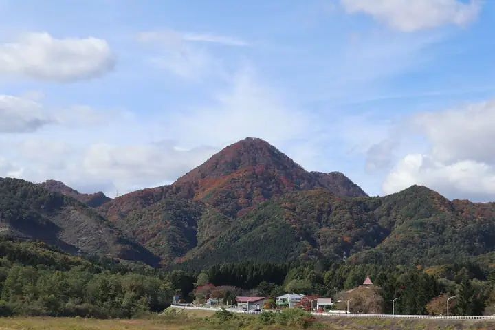
Mt. Nanshōzan is an 848-meter peak on the boundary between Yahaba Town in Shiwa District and Shizukuishi Town in Iwate District, Iwate Prefecture, treated as a symbol of Yahaba for its near-perfect inverted-bell profile. Long an object of local mountain worship, it is counted as one of the Shiwa Three Mountains alongside Higashine and Hakogamori (or Akabayashi). Two routes ascend from Yahaba Onsen: a general course of about two hours and the steeper Maekura Course fitted with fixed ropes. The town and tourism association hold an annual mountain-opening ceremony in late May, and the peak is included in the Iwate Hyakumeizan and Iwate-no-Yama 150 lists.
Mt. Nanshouzan at a glance
- Weather: The most settled day in the next 7 days is Wed, November 4: clear, gusts up to 7 m/s. Sat, Nov 7, Sun, Nov 8: strong wind (gusts up to 19 m/s).
Mt. Nanshouzan weather (hourly, 14 days)
Sunrise today 06:05, sunset 16:33
| Tue, 11/3 | Wed, 11/4 | Thu, 11/5 | Fri, 11/6 | Sat, 11/7 | Sun, 11/8 | Mon, 11/9 | Tue, 11/10 | Wed, 11/11 | Thu, 11/12 | Fri, 11/13 | Sat, 11/14 | Sun, 11/15 | Mon, 11/16 | Tue, 11/17 | |||||||||||||||||||||||||||||||||||||||||||||||||||||||||||||||||||||||
|---|---|---|---|---|---|---|---|---|---|---|---|---|---|---|---|---|---|---|---|---|---|---|---|---|---|---|---|---|---|---|---|---|---|---|---|---|---|---|---|---|---|---|---|---|---|---|---|---|---|---|---|---|---|---|---|---|---|---|---|---|---|---|---|---|---|---|---|---|---|---|---|---|---|---|---|---|---|---|---|---|---|---|---|---|---|
| Japan time | 15 | 17 | 19 | 21 | 23 | 1 | 3 | 5 | 7 | 9 | 11 | 13 | 15 | 18 | 21 | 0 | 3 | 6 | 9 | 12 | 15 | 18 | 21 | 0 | 3 | 6 | 9 | 12 | 15 | 18 | 21 | 0 | 3 | 6 | 9 | 12 | 15 | 18 | 21 | 0 | 3 | 6 | 9 | 12 | 15 | 18 | 21 | 0 | 3 | 6 | 9 | 15 | 21 | 3 | 9 | 15 | 21 | 3 | 9 | 15 | 21 | 3 | 9 | 15 | 21 | 3 | 9 | 15 | 21 | 3 | 9 | 15 | 21 | 3 | 9 | 15 | 21 | 3 | 9 | 15 | 21 | 3 | 9 | 15 | |
 |  | | | |   |   |   |   | | | | | | | |   |   |   | | | | | | | | |   | |   | | | |   |   | |   | | | | | | | |   | | | | | | | | | | | | | | | |   | | |   | | |   | | |  | | | | | | | | | | | |  | | | ||
| Temperature | °C | 8° | 5° | 3° | 2° | 0° | -1° | 0° | 1° | 2° | 7° | 11° | 12° | 11° | 4° | 2° | 2° | 1° | 4° | 6° | 7° | 8° | 7° | 7° | 7° | 7° | 7° | 10° | 12° | 11° | 8° | 4° | 2° | 1° | 1° | 1° | 3° | 2° | 0° | 0° | 0° | 0° | 0° | 3° | 5° | 4° | 2° | 0° | 0° | -1° | -2° | 4° | 4° | -2° | -3° | 2° | 6° | 1° | 1° | 3° | 3° | 0° | -3° | 3° | 6° | 2° | 2° | 2° | 4° | -3° | -5° | 1° | 7° | -3° | -5° | 4° | 9° | 4° | 3° | 7° | 5° | -1° | -3° | 2° | 5° |
| Precipitation | mm | 0.2 | 1.1 | 4.2 | 4.4 | 1.3 | 0.3 | 0.9 | 1.8 | 1.6 | 0.4 | 1.4 | 0.5 | 0.4 | 0.7 | 1.0 | 1.1 | 1.2 | 0.8 | 1.1 | 0.7 | 0.2 | 0.2 | 0.1 | 1.2 | 8 | 4.2 | 0.8 | 2.8 | 0.3 | 0.1 | 3.3 | 2.2 | 0.9 | 1.0 | ||||||||||||||||||||||||||||||||||||||||||||||||||
| New snow | cm | <.1 | <.1 | <.1 | 0.2 | <.1 | <.1 | <.1 | <.1 | <.1 | <.1 | <.1 | 0.1 | <.1 | |||||||||||||||||||||||||||||||||||||||||||||||||||||||||||||||||||||||
| Snow depth | cm | 0 | 0 | 0 | 0 | 0 | 0 | 0 | 0 | 0 | 0 | 0 | 0 | 0 | 0 | 0 | 0 | 0 | 0 | 0 | 0 | 0 | 0 | 0 | 0 | 0 | 0 | 0 | 0 | 0 | 0 | 0 | 0 | 0 | <1 | <1 | <1 | <1 | <1 | <1 | <1 | <1 | <1 | <1 | <1 | <1 | <1 | <1 | 0 | 0 | <1 | 0 | 0 | 0 | 0 | 0 | 0 | <1 | <1 | <1 | 0 | 0 | 0 | 0 | 0 | 0 | 0 | 0 | 0 | 0 | 0 | 0 | 0 | 0 | 0 | 0 | 0 | 0 | 0 | 0 | 0 | 0 | 0 | 0 | 0 |
| Wind | m/s | 4 | 2 | 1 | 1 | 1 | 2 | 1 | 1 | 1 | 2 | 2 | 3 | 2 | 1 | 0 | 1 | 1 | 1 | 1 | 2 | 1 | 1 | 1 | 0 | 0 | 1 | 1 | 3 | 5 | 5 | 6 | 5 | 5 | 3 | 3 | 5 | 4 | 3 | 3 | 3 | 3 | 3 | 6 | 8 | 6 | 4 | 2 | 1 | 1 | 2 | 2 | 3 | 1 | 1 | 1 | 4 | 1 | 1 | 2 | 4 | 0 | 1 | 1 | 3 | 1 | 0 | 2 | 4 | 0 | 0 | 1 | 2 | 1 | 0 | 0 | 1 | 1 | 1 | 0 | 3 | 2 | 0 | 0 | 3 |
| Wind gusts | m/s | 12 | 10 | 6 | 4 | 4 | 5 | 5 | 4 | 4 | 5 | 7 | 7 | 7 | 4 | 3 | 3 | 4 | 4 | 4 | 4 | 3 | 2 | 3 | 3 | 3 | 3 | 3 | 10 | 14 | 13 | 15 | 16 | 13 | 12 | 12 | 17 | 17 | 13 | 9 | 9 | 9 | 9 | 15 | 19 | 19 | 14 | 10 | 5 | 4 | 5 | 6 | 9 | 8 | 4 | 4 | 9 | 11 | 5 | 7 | 15 | 10 | 3 | 4 | 9 | 7 | 3 | 6 | 11 | 10 | 3 | 4 | 6 | 6 | 3 | 3 | 6 | 3 | 3 | 3 | 8 | 11 | 7 | 4 | 8 |
| Wind dir. | ↓ | ↓ | ↓ | ↓ | ↓ | ↓ | ↓ | ↓ | ↓ | ↓ | ↓ | ↓ | ↓ | ↓ | ↓ | ↓ | ↓ | ↓ | ↓ | ↓ | ↓ | ↓ | ↓ | ↓ | ↓ | ↓ | ↓ | ↓ | ↓ | ↓ | ↓ | ↓ | ↓ | ↓ | ↓ | ↓ | ↓ | ↓ | ↓ | ↓ | ↓ | ↓ | ↓ | ↓ | ↓ | ↓ | ↓ | ↓ | ↓ | ↓ | ↓ | ↓ | ↓ | ↓ | ↓ | ↓ | ↓ | ↓ | ↓ | ↓ | ↓ | ↓ | ↓ | ↓ | ↓ | ↓ | ↓ | ↓ | ↓ | ↓ | ↓ | ↓ | ↓ | ↓ | ↓ | ↓ | ↓ | ↓ | ↓ | ↓ | ↓ | ↓ | ↓ | ||
Huts, campsites and lodging near Mt. Nanshouzan
Campsites
- 矢巾町営キャンプ場
Lists that include Mt. Nanshouzan
Illustrated Collection of Japan's Famous Mountains · Iwate 100 Famous Mountains
Mt. Nanshouzan facts
- Elevation
- 848 m
- Location
- Yahaba, Iwate
39.622648, 141.057007 - Website
- www.town.yahaba.iwate.jp
- Wikipedia
- ja.wikipedia.org