
Mt. Miwayama
三輪山
Sakurai, Nara · Elevation 467 m
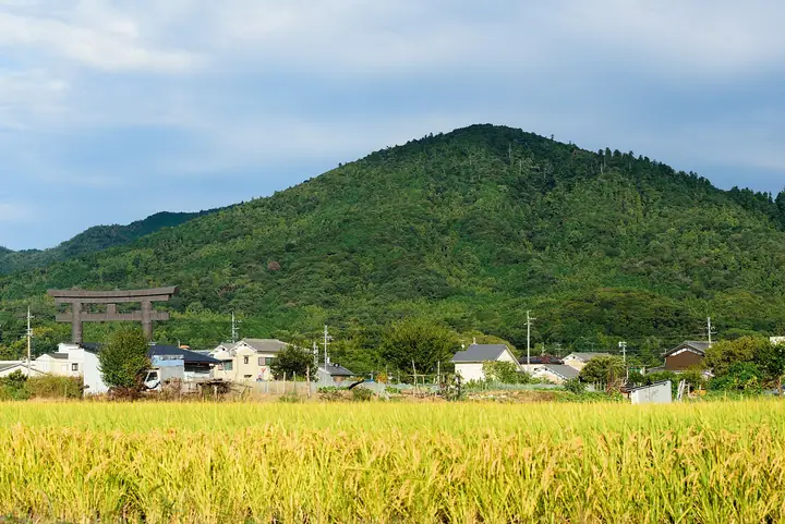
Mount Miwayama (467.1 m, circumference 16 km) is a gently conical sacred mountain in Sakurai City, Nara, regarded by Ōmiwa Shrine at its foot as the very body of its enshrined deity—one of Japan's oldest kamunabi (god-dwelling mountains). Historically a forbidden sanctuary, the peak today admits pilgrims only via registration at the auxiliary Sai Shrine (9:00–noon, 300-yen offering, white sash, with photography, food and fire prohibited). It is listed in the Japan 100 Sacred Peaks, Kansai 100 and Japan 100 Low Mountains selections.
Mt. Miwayama at a glance
- Weather: The most settled day in the next 7 days is Thu, November 5: cloudy, gusts up to 5 m/s.
- Route: The shortest is Sacred Mount Miwa Pilgrimage from Sai Shrine: about 2 h 27 min, 4.2 km, about 380 m of climbing.
Mt. Miwayama weather (hourly, 14 days)
Sunrise today 06:18, sunset 17:02
| Tue, 11/3 | Wed, 11/4 | Thu, 11/5 | Fri, 11/6 | Sat, 11/7 | Sun, 11/8 | Mon, 11/9 | Tue, 11/10 | Wed, 11/11 | Thu, 11/12 | Fri, 11/13 | Sat, 11/14 | Sun, 11/15 | Mon, 11/16 | Tue, 11/17 | |||||||||||||||||||||||||||||||||||||||||||||||||||||||||||||||||||||||
|---|---|---|---|---|---|---|---|---|---|---|---|---|---|---|---|---|---|---|---|---|---|---|---|---|---|---|---|---|---|---|---|---|---|---|---|---|---|---|---|---|---|---|---|---|---|---|---|---|---|---|---|---|---|---|---|---|---|---|---|---|---|---|---|---|---|---|---|---|---|---|---|---|---|---|---|---|---|---|---|---|---|---|---|---|---|
| Japan time | 15 | 17 | 19 | 21 | 23 | 1 | 3 | 5 | 7 | 9 | 11 | 13 | 15 | 18 | 21 | 0 | 3 | 6 | 9 | 12 | 15 | 18 | 21 | 0 | 3 | 6 | 9 | 12 | 15 | 18 | 21 | 0 | 3 | 6 | 9 | 12 | 15 | 18 | 21 | 0 | 3 | 6 | 9 | 12 | 15 | 18 | 21 | 0 | 3 | 6 | 9 | 15 | 21 | 3 | 9 | 15 | 21 | 3 | 9 | 15 | 21 | 3 | 9 | 15 | 21 | 3 | 9 | 15 | 21 | 3 | 9 | 15 | 21 | 3 | 9 | 15 | 21 | 3 | 9 | 15 | 21 | 3 | 9 | 15 | |
  |   |   | | | | | |   | | | | |   | | |   |   |   | | | | | | |   | |   | | | | |  | |  | | | | | | | | | | | | |   | | | | | |   | | | | | | | |  | | | | | | | | | | | | | | | | |   | | |  | | | ||
| Temperature | °C | 16° | 13° | 11° | 11° | 9° | 7° | 7° | 6° | 6° | 12° | 15° | 17° | 16° | 14° | 13° | 13° | 13° | 12° | 15° | 17° | 18° | 15° | 13° | 13° | 13° | 14° | 15° | 17° | 16° | 14° | 11° | 9° | 8° | 7° | 10° | 12° | 11° | 8° | 6° | 5° | 4° | 3° | 9° | 12° | 12° | 8° | 8° | 8° | 7° | 8° | 11° | 13° | 9° | 6° | 11° | 14° | 8° | 6° | 8° | 10° | 5° | 3° | 8° | 12° | 5° | 5° | 9° | 11° | 5° | 1° | 9° | 14° | 5° | 4° | 13° | 16° | 11° | 11° | 14° | 15° | 9° | 5° | 8° | 11° |
| Precipitation | mm | 0.7 | 0.2 | 0.2 | 0.3 | 10 | 1.0 | 0.6 | 1.3 | 0.2 | 0.2 | 0.1 | 0.1 | 0.1 | 0.5 | 9 | 0.7 | 0.9 | |||||||||||||||||||||||||||||||||||||||||||||||||||||||||||||||||||
| New snow | cm | ||||||||||||||||||||||||||||||||||||||||||||||||||||||||||||||||||||||||||||||||||||
| Snow depth | cm | 0 | 0 | 0 | 0 | 0 | 0 | 0 | 0 | 0 | 0 | 0 | 0 | 0 | 0 | 0 | 0 | 0 | 0 | 0 | 0 | 0 | 0 | 0 | 0 | 0 | 0 | 0 | 0 | 0 | 0 | 0 | 0 | 0 | 0 | 0 | 0 | 0 | 0 | 0 | 0 | 0 | 0 | 0 | 0 | 0 | 0 | 0 | 0 | 0 | 0 | 0 | 0 | 0 | 0 | 0 | 0 | 0 | 0 | 0 | 0 | 0 | 0 | 0 | 0 | 0 | 0 | 0 | 0 | 0 | 0 | 0 | 0 | 0 | 0 | 0 | 0 | 0 | 0 | 0 | 0 | 0 | 0 | 0 | 0 |
| Wind | m/s | 3 | 2 | 1 | 1 | 1 | 1 | 1 | 1 | 1 | 1 | 2 | 3 | 3 | 4 | 3 | 2 | 3 | 2 | 1 | 2 | 1 | 0 | 0 | 1 | 1 | 2 | 3 | 4 | 5 | 3 | 3 | 3 | 2 | 2 | 4 | 5 | 5 | 3 | 1 | 1 | 1 | 1 | 0 | 3 | 3 | 1 | 0 | 0 | 0 | 1 | 1 | 2 | 1 | 1 | 2 | 4 | 1 | 4 | 3 | 5 | 1 | 1 | 1 | 2 | 1 | 1 | 2 | 4 | 1 | 1 | 0 | 2 | 1 | 1 | 1 | 2 | 2 | 2 | 2 | 5 | 2 | 1 | 1 | 2 |
| Wind gusts | m/s | 6 | 6 | 5 | 3 | 2 | 3 | 3 | 3 | 3 | 4 | 5 | 8 | 8 | 9 | 9 | 7 | 7 | 7 | 4 | 4 | 5 | 4 | 2 | 4 | 5 | 6 | 8 | 11 | 12 | 11 | 9 | 7 | 7 | 6 | 10 | 12 | 13 | 12 | 7 | 3 | 2 | 2 | 3 | 8 | 9 | 7 | 2 | 1 | 1 | 1 | 3 | 7 | 6 | 2 | 5 | 10 | 9 | 9 | 9 | 15 | 13 | 3 | 4 | 7 | 6 | 4 | 5 | 12 | 10 | 3 | 3 | 6 | 6 | 3 | 4 | 8 | 5 | 6 | 5 | 12 | 12 | 6 | 4 | 7 |
| Wind dir. | ↓ | ↓ | ↓ | ↓ | ↓ | ↓ | ↓ | ↓ | ↓ | ↓ | ↓ | ↓ | ↓ | ↓ | ↓ | ↓ | ↓ | ↓ | ↓ | ↓ | ↓ | ↓ | ↓ | ↓ | ↓ | ↓ | ↓ | ↓ | ↓ | ↓ | ↓ | ↓ | ↓ | ↓ | ↓ | ↓ | ↓ | ↓ | ↓ | ↓ | ↓ | ↓ | ↓ | ↓ | ↓ | ↓ | ↓ | ↓ | ↓ | ↓ | ↓ | ↓ | ↓ | ↓ | ↓ | ↓ | ↓ | ↓ | ↓ | ↓ | ↓ | ↓ | ↓ | ↓ | ↓ | ↓ | ↓ | ↓ | ↓ | ↓ | ↓ | ↓ | ↓ | ↓ | ↓ | ↓ | ↓ | ↓ | ↓ | ↓ | ↓ | ↓ | ↓ | ↓ | |
Mt. Miwayama hiking routes
- Sacred Mount Miwa Pilgrimage from Sai Shrine 4.2 km · Ascent 378 m 月山鍛刀塲P
- Mount Miwa, a Sacred Mountain Worshipped Itself without a Main Hall: a Pilgrim Climb past Iwakura Stones to the Top 5.1 km · Ascent 397 m 大神神社第6駐車場, 大神神社第5駐車場, 大神神社第4駐車場, 大神神社第3駐車場 (parking)
Hiking times are estimates calculated from the terrain.
Huts, campsites and lodging near Mt. Miwayama
Lodging
- Tokiwa Ryokan
- Ryokan Kaikaro
- ペンション サンチェリー
- 三晴旅館
- Itaniya
Lists that include Mt. Miwayama
100 Low Mountains of Japan · Kansai 100 Famous Mountains · Nara 100 Mountains to Explore · Elevations of 1003 Mountains of Japan
Mt. Miwayama facts
- Also known as
- 御諸山 · 三諸山
- Elevation
- 467 m
- Location
- Sakurai, Nara
34.535034, 135.866799 - Website
- oomiwa.or.jp
- Access Information
- oomiwa.or.jp
- Wikipedia
- en.wikipedia.org