
Mt. Misen
弥山
Tenkawa, Nara · Elevation 1,895 m
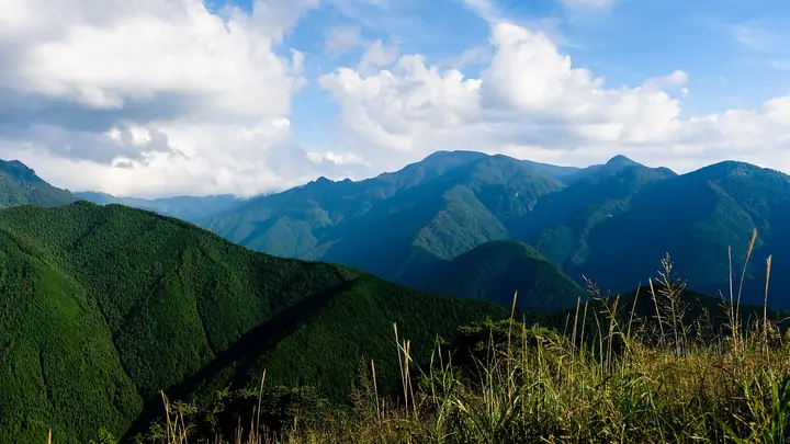
Mt. Misen is a 1,895 m peak on the border of Kamikitayama and Tenkawa Villages in Yoshino District, Nara Prefecture, at the centre of the Ōmine Mountains. Its name comes from Mount Sumeru of Buddhist cosmology, and a branch shrine of Tenkawa Daibenzaiten (the Misen Shrine) stands on top. Together with neighbouring Mt. Hakkyō-ga-take it forms a key section of the World Heritage Ōmine Okugake-michi pilgrimage route. The summit is surrounded by virgin Veitch's fir and spruce forest, and large colonies of Oyama-renge magnolia bloom in early July. Within Yoshino-Kumano National Park, the Misen-goya hut (operating late April through mid-November) provides the standard base for climbers.
Mt. Misen at a glance
- Weather: The most settled day in the next 7 days is Thu, November 5: cloudy, gusts up to 6 m/s. Fri, Nov 6, Sat, Nov 7, Sun, Nov 8: strong wind (gusts up to 19 m/s).
- Route: The shortest is Misen, Mount Hakkyō and Myōjōgatake Return from Gyōjagaeri Tunnel West Entrance: about 7 h 38 min, 11.7 km, about 1,180 m of climbing.
Mt. Misen weather (hourly, 14 days)
Sunrise today 06:17, sunset 17:03
| Tue, 11/3 | Wed, 11/4 | Thu, 11/5 | Fri, 11/6 | Sat, 11/7 | Sun, 11/8 | Mon, 11/9 | Tue, 11/10 | Wed, 11/11 | Thu, 11/12 | Fri, 11/13 | Sat, 11/14 | Sun, 11/15 | Mon, 11/16 | Tue, 11/17 | |||||||||||||||||||||||||||||||||||||||||||||||||||||||||||||||||||||||
|---|---|---|---|---|---|---|---|---|---|---|---|---|---|---|---|---|---|---|---|---|---|---|---|---|---|---|---|---|---|---|---|---|---|---|---|---|---|---|---|---|---|---|---|---|---|---|---|---|---|---|---|---|---|---|---|---|---|---|---|---|---|---|---|---|---|---|---|---|---|---|---|---|---|---|---|---|---|---|---|---|---|---|---|---|---|
| Japan time | 15 | 17 | 19 | 21 | 23 | 1 | 3 | 5 | 7 | 9 | 11 | 13 | 15 | 18 | 21 | 0 | 3 | 6 | 9 | 12 | 15 | 18 | 21 | 0 | 3 | 6 | 9 | 12 | 15 | 18 | 21 | 0 | 3 | 6 | 9 | 12 | 15 | 18 | 21 | 0 | 3 | 6 | 9 | 12 | 15 | 18 | 21 | 0 | 3 | 6 | 9 | 15 | 21 | 3 | 9 | 15 | 21 | 3 | 9 | 15 | 21 | 3 | 9 | 15 | 21 | 3 | 9 | 15 | 21 | 3 | 9 | 15 | 21 | 3 | 9 | 15 | 21 | 3 | 9 | 15 | 21 | 3 | 9 | 15 | |
  | |   |   | | | | | |   |   | |   |   | | |   | | |   | | | | | | | |   | | | | | | | | | | | | | | |  | | | | | | | | | | |   | | | | | | | |  | | | | | | | | | | | | | | | | | | | | | | | ||
| Temperature | °C | 8° | 4° | 2° | 2° | 1° | 0° | 1° | 1° | 1° | 7° | 9° | 8° | 6° | 4° | 5° | 5° | 6° | 6° | 10° | 11° | 11° | 7° | 6° | 6° | 7° | 7° | 6° | 8° | 7° | 4° | 2° | 0° | -2° | -3° | 0° | 1° | 1° | -2° | -4° | -4° | -4° | -3° | 2° | 5° | 4° | -1° | 0° | 0° | -1° | 0° | 4° | 5° | -1° | -2° | 4° | 5° | 0° | -4° | -2° | 0° | -4° | -5° | 1° | 4° | -3° | -3° | 0° | 1° | -4° | -5° | 3° | 6° | 0° | 1° | 5° | 6° | 6° | 7° | 6° | 5° | 0° | -4° | 0° | 5° |
| Precipitation | mm | 0.4 | 0.2 | 0.3 | 0.3 | 0.5 | 0.5 | 0.3 | 1.1 | 0.5 | 0.3 | 0.5 | 0.2 | 0.1 | 0.5 | 1.1 | 5.0 | 11 | 0.4 | 1.8 | 1.0 | ||||||||||||||||||||||||||||||||||||||||||||||||||||||||||||||||
| New snow | cm | ||||||||||||||||||||||||||||||||||||||||||||||||||||||||||||||||||||||||||||||||||||
| Snow depth | cm | 0 | 0 | 0 | 0 | 0 | 0 | 0 | 0 | 0 | 0 | 0 | 0 | 0 | 0 | 0 | 0 | 0 | 0 | 0 | 0 | 0 | 0 | 0 | 0 | 0 | 0 | 0 | 0 | 0 | 0 | 0 | 0 | 0 | 0 | 0 | 0 | 0 | 0 | 0 | 0 | 0 | 0 | 0 | 0 | 0 | 0 | 0 | 0 | 0 | 0 | 0 | 0 | 0 | 0 | 0 | 0 | 0 | 0 | 0 | 0 | 0 | 0 | 0 | 0 | 0 | 0 | 0 | 0 | 0 | 0 | 0 | 0 | 0 | 0 | 0 | 0 | 0 | 0 | 0 | 0 | 0 | 0 | 0 | 0 |
| Wind | m/s | 2 | 2 | 2 | 2 | 2 | 2 | 3 | 3 | 2 | 1 | 2 | 2 | 2 | 2 | 2 | 2 | 2 | 1 | 2 | 1 | 1 | 1 | 0 | 1 | 2 | 3 | 4 | 4 | 5 | 4 | 4 | 5 | 5 | 4 | 6 | 5 | 5 | 4 | 4 | 4 | 4 | 5 | 4 | 3 | 2 | 2 | 2 | 0 | 2 | 2 | 3 | 3 | 1 | 1 | 1 | 3 | 3 | 7 | 7 | 6 | 5 | 3 | 2 | 2 | 2 | 3 | 3 | 5 | 4 | 2 | 1 | 2 | 1 | 1 | 3 | 3 | 4 | 2 | 4 | 4 | 5 | 4 | 3 | 1 |
| Wind gusts | m/s | 8 | 8 | 8 | 7 | 6 | 7 | 9 | 9 | 8 | 6 | 7 | 7 | 7 | 7 | 8 | 8 | 7 | 6 | 6 | 6 | 6 | 6 | 7 | 8 | 11 | 13 | 14 | 14 | 16 | 16 | 14 | 17 | 17 | 18 | 19 | 19 | 19 | 17 | 15 | 15 | 15 | 16 | 15 | 13 | 9 | 9 | 8 | 5 | 5 | 9 | 9 | 10 | 9 | 5 | 5 | 11 | 12 | 22 | 26 | 25 | 20 | 16 | 9 | 8 | 8 | 11 | 13 | 17 | 17 | 13 | 7 | 7 | 7 | 7 | 10 | 12 | 16 | 16 | 12 | 15 | 17 | 17 | 14 | 10 |
| Wind dir. | ↓ | ↓ | ↓ | ↓ | ↓ | ↓ | ↓ | ↓ | ↓ | ↓ | ↓ | ↓ | ↓ | ↓ | ↓ | ↓ | ↓ | ↓ | ↓ | ↓ | ↓ | ↓ | ↓ | ↓ | ↓ | ↓ | ↓ | ↓ | ↓ | ↓ | ↓ | ↓ | ↓ | ↓ | ↓ | ↓ | ↓ | ↓ | ↓ | ↓ | ↓ | ↓ | ↓ | ↓ | ↓ | ↓ | ↓ | ↓ | ↓ | ↓ | ↓ | ↓ | ↓ | ↓ | ↓ | ↓ | ↓ | ↓ | ↓ | ↓ | ↓ | ↓ | ↓ | ↓ | ↓ | ↓ | ↓ | ↓ | ↓ | ↓ | ↓ | ↓ | ↓ | ↓ | ↓ | ↓ | ↓ | ↓ | ↓ | ↓ | ↓ | ↓ | ↓ | ↓ | |
Mt. Misen hiking routes
- Misen, Mount Hakkyō and Myōjōgatake Return from Gyōjagaeri Tunnel West Entrance 11.7 km · Ascent 1,175 m parking
- Mount Misen and Mount Hakkyo Loop from Tenkawa-Kawai 23.2 km · Ascent 1,657 m 川合登山口, Tenkawa-kawai (Bus stop), 天川川合バス停 (Bus stop) (parking)
Hiking times are estimates calculated from the terrain.
Huts, campsites and lodging near Mt. Misen
Mountain huts
Lists that include Mt. Misen
Ōmine Okugakemichi · Elevations of 1003 Mountains of Japan · 1000 Mountains of Japan
Mt. Misen facts
- Elevation
- 1,895 m
- Location
- Tenkawa, Nara
34.180113, 135.909328 - National Park
- 吉野熊野国立公園
- Website
- www.vill.tenkawa.nara.jp
- Trail Map
- www.vill.tenkawa.nara.jp (PDF)