
Mount Shaka
釈迦ヶ岳
Shimokitayama, Nara · Elevation 1,800 m
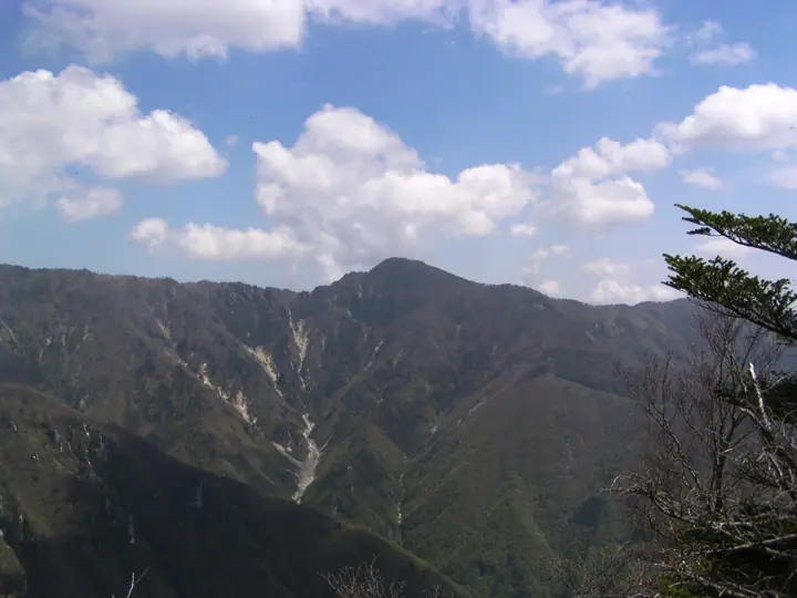
Mount Shaka is a 1,799.87 m peak straddling Shimokitayama Village and Totsukawa Village in Yoshino District, Nara Prefecture, the fourth-highest summit of the Ōmine Range after Hakkyō-ga-take, Misen, and Myōjō-ga-take, within Yoshino-Kumano National Park. It carries a first-order triangulation marker and is listed in the Nihon Nihyaku Meizan, the Ittō-Sankakuten Hyakumeizan, and the Kansai Hyakumeizan among others. A bronze statue of Shakyamuni Buddha — carried up in 1924 by the lineage of "Onizen-ki Goki-suke" — stands on the summit, and the peak remains an active sacred site on the Ōmine-Okugake-michi pilgrimage route, a component of the UNESCO World Heritage "Sacred Sites and Pilgrimage Routes in the Kii Mountain Range." The pyramidal summit offers a 360° panorama spanning the Daikō Range, Kasasute-yama, Tamaki-yama, and Hakkyō-ga-take. The standard ascent climbs the ridge from the Futa-o trailhead above the Asahi Dam in Totsukawa, while the older Zenki route from Shimokitayama is still walked by yamabushi practitioners.
Mount Shaka at a glance
- Weather: The most settled day in the next 7 days is Thu, November 5: cloudy, gusts up to 6 m/s. Fri, Nov 6, Sat, Nov 7, Sun, Nov 8: strong wind (gusts up to 19 m/s).
- Route: The shortest is Mount Shaka Return via Furuta-no-mori from Futoo Trailhead: about 4 h 56 min, 8.3 km, about 620 m of climbing.
Mount Shaka weather (hourly, 14 days)
Sunrise today 06:17, sunset 17:03
| Tue, 11/3 | Wed, 11/4 | Thu, 11/5 | Fri, 11/6 | Sat, 11/7 | Sun, 11/8 | Mon, 11/9 | Tue, 11/10 | Wed, 11/11 | Thu, 11/12 | Fri, 11/13 | Sat, 11/14 | Sun, 11/15 | Mon, 11/16 | Tue, 11/17 | |||||||||||||||||||||||||||||||||||||||||||||||||||||||||||||||||||||||
|---|---|---|---|---|---|---|---|---|---|---|---|---|---|---|---|---|---|---|---|---|---|---|---|---|---|---|---|---|---|---|---|---|---|---|---|---|---|---|---|---|---|---|---|---|---|---|---|---|---|---|---|---|---|---|---|---|---|---|---|---|---|---|---|---|---|---|---|---|---|---|---|---|---|---|---|---|---|---|---|---|---|---|---|---|---|
| Japan time | 15 | 17 | 19 | 21 | 23 | 1 | 3 | 5 | 7 | 9 | 11 | 13 | 15 | 18 | 21 | 0 | 3 | 6 | 9 | 12 | 15 | 18 | 21 | 0 | 3 | 6 | 9 | 12 | 15 | 18 | 21 | 0 | 3 | 6 | 9 | 12 | 15 | 18 | 21 | 0 | 3 | 6 | 9 | 12 | 15 | 18 | 21 | 0 | 3 | 6 | 9 | 15 | 21 | 3 | 9 | 15 | 21 | 3 | 9 | 15 | 21 | 3 | 9 | 15 | 21 | 3 | 9 | 15 | 21 | 3 | 9 | 15 | 21 | 3 | 9 | 15 | 21 | 3 | 9 | 15 | 21 | 3 | 9 | 15 | |
  | |   |   | | | | | |   |   | |   |   | | |   | | |   | | | | | | | |   | | | | | | | | | | | | | | |  | | | | | | | | | | |   | | | | | | | |  | | | | | | | | | | | | | | | | | | | | | | | ||
| Temperature | °C | 8° | 4° | 3° | 2° | 2° | 1° | 2° | 1° | 1° | 8° | 10° | 9° | 7° | 5° | 5° | 6° | 6° | 6° | 11° | 11° | 12° | 8° | 6° | 6° | 8° | 7° | 7° | 9° | 8° | 4° | 3° | 1° | -1° | -2° | 1° | 2° | 2° | -2° | -3° | -3° | -3° | -3° | 3° | 6° | 5° | -1° | 0° | 0° | 0° | 1° | 5° | 5° | 0° | -1° | 4° | 6° | 0° | -3° | -1° | 1° | -3° | -4° | 2° | 5° | -2° | -3° | 0° | 2° | -3° | -4° | 4° | 7° | 1° | 2° | 5° | 6° | 7° | 7° | 7° | 6° | 1° | -3° | 1° | 6° |
| Precipitation | mm | 0.4 | 0.2 | 0.3 | 0.3 | 0.5 | 0.5 | 0.3 | 1.1 | 0.5 | 0.3 | 0.5 | 0.2 | 0.1 | 0.5 | 1.1 | 5.0 | 11 | 0.4 | 1.8 | 1.0 | ||||||||||||||||||||||||||||||||||||||||||||||||||||||||||||||||
| New snow | cm | ||||||||||||||||||||||||||||||||||||||||||||||||||||||||||||||||||||||||||||||||||||
| Snow depth | cm | 0 | 0 | 0 | 0 | 0 | 0 | 0 | 0 | 0 | 0 | 0 | 0 | 0 | 0 | 0 | 0 | 0 | 0 | 0 | 0 | 0 | 0 | 0 | 0 | 0 | 0 | 0 | 0 | 0 | 0 | 0 | 0 | 0 | 0 | 0 | 0 | 0 | 0 | 0 | 0 | 0 | 0 | 0 | 0 | 0 | 0 | 0 | 0 | 0 | 0 | 0 | 0 | 0 | 0 | 0 | 0 | 0 | 0 | 0 | 0 | 0 | 0 | 0 | 0 | 0 | 0 | 0 | 0 | 0 | 0 | 0 | 0 | 0 | 0 | 0 | 0 | 0 | 0 | 0 | 0 | 0 | 0 | 0 | 0 |
| Wind | m/s | 2 | 2 | 2 | 2 | 2 | 2 | 3 | 3 | 2 | 1 | 2 | 2 | 2 | 2 | 2 | 2 | 2 | 1 | 2 | 1 | 1 | 1 | 0 | 1 | 2 | 3 | 4 | 4 | 5 | 4 | 4 | 5 | 5 | 4 | 6 | 5 | 5 | 4 | 4 | 4 | 4 | 5 | 4 | 3 | 2 | 2 | 2 | 0 | 2 | 2 | 3 | 3 | 1 | 1 | 1 | 3 | 3 | 7 | 7 | 6 | 5 | 3 | 2 | 2 | 2 | 3 | 3 | 5 | 4 | 2 | 1 | 2 | 1 | 1 | 3 | 3 | 4 | 2 | 4 | 4 | 5 | 4 | 3 | 1 |
| Wind gusts | m/s | 8 | 8 | 8 | 7 | 6 | 7 | 9 | 9 | 8 | 6 | 7 | 7 | 7 | 7 | 8 | 8 | 7 | 6 | 6 | 6 | 6 | 6 | 7 | 8 | 11 | 13 | 14 | 14 | 16 | 16 | 14 | 17 | 17 | 18 | 19 | 19 | 19 | 17 | 15 | 15 | 15 | 16 | 15 | 13 | 9 | 9 | 8 | 5 | 5 | 9 | 9 | 10 | 9 | 5 | 5 | 11 | 12 | 22 | 26 | 25 | 20 | 16 | 9 | 8 | 8 | 11 | 13 | 17 | 17 | 13 | 7 | 7 | 7 | 7 | 10 | 12 | 16 | 16 | 12 | 15 | 17 | 17 | 14 | 10 |
| Wind dir. | ↓ | ↓ | ↓ | ↓ | ↓ | ↓ | ↓ | ↓ | ↓ | ↓ | ↓ | ↓ | ↓ | ↓ | ↓ | ↓ | ↓ | ↓ | ↓ | ↓ | ↓ | ↓ | ↓ | ↓ | ↓ | ↓ | ↓ | ↓ | ↓ | ↓ | ↓ | ↓ | ↓ | ↓ | ↓ | ↓ | ↓ | ↓ | ↓ | ↓ | ↓ | ↓ | ↓ | ↓ | ↓ | ↓ | ↓ | ↓ | ↓ | ↓ | ↓ | ↓ | ↓ | ↓ | ↓ | ↓ | ↓ | ↓ | ↓ | ↓ | ↓ | ↓ | ↓ | ↓ | ↓ | ↓ | ↓ | ↓ | ↓ | ↓ | ↓ | ↓ | ↓ | ↓ | ↓ | ↓ | ↓ | ↓ | ↓ | ↓ | ↓ | ↓ | ↓ | ↓ | |
Mount Shaka hiking routes
Hiking times are estimates calculated from the terrain.
Huts, campsites and lodging near Mount Shaka
Mountain huts
Lodging
- 小仲坊
Lists that include Mount Shaka
Japan 200 Famous Mountains · Japan's 300 Famous Mountains · 100 Famous Mountains with First-order Triangulation Points · New Japan 100 Famous Mountains · Kansai 100 Famous Mountains · Kinki 100 Famous Mountains · Nara 100 Mountains to Explore · Ōmine Okugakemichi · Elevations of 1003 Mountains of Japan · 1000 Mountains of Japan
Mount Shaka facts
- Elevation
- 1,800 m
- Location
- Shimokitayama, Nara
34.114327, 135.903164 - National Park
- 吉野熊野国立公園
- Website
- totsukawa.info
- Trail Map
- www.vill.totsukawa.lg.jp (PDF)
- Wikipedia
- ja.wikipedia.org