
Mt. Gyōjagaeri
行者還岳
Tenkawa, Nara / Kamikitayama, Nara · Elevation 1,547 m
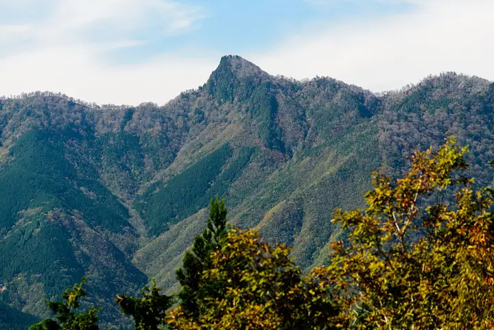
Mt. Gyōjagaeri is a 1,546.6 m peak on the border of Kamikitayama and Tenkawa Villages in Yoshino District, Nara Prefecture, in the northern Ōmine Mountains between Mt. Daifugen and Mt. Misen. Legend says that even En-no-Gyōja, the founder of Shugendō, turned back at its sheer cliffs — hence the name ("the priest's turnaround peak"). An unmanned emergency hut stands just below the summit on the World-Heritage Ōmine Okugake-michi, a flower corridor of rhododendrons and Shirayashio azaleas from late May. Within Yoshino-Kumano National Park, the standard climb from the Gyōjagaeri Tunnel west portal on Route 309 takes about 1 h 50 min to the summit.
Mt. Gyōjagaeri at a glance
- Weather: The most settled day in the next 7 days is Mon, November 9: clear, gusts up to 10 m/s. Fri, Nov 6, Sat, Nov 7: strong wind (gusts up to 19 m/s).
Mt. Gyōjagaeri weather (hourly, 14 days)
Sunrise today 06:17, sunset 17:03
| Tue, 11/3 | Wed, 11/4 | Thu, 11/5 | Fri, 11/6 | Sat, 11/7 | Sun, 11/8 | Mon, 11/9 | Tue, 11/10 | Wed, 11/11 | Thu, 11/12 | Fri, 11/13 | Sat, 11/14 | Sun, 11/15 | Mon, 11/16 | Tue, 11/17 | |||||||||||||||||||||||||||||||||||||||||||||||||||||||||||||||||||||||
|---|---|---|---|---|---|---|---|---|---|---|---|---|---|---|---|---|---|---|---|---|---|---|---|---|---|---|---|---|---|---|---|---|---|---|---|---|---|---|---|---|---|---|---|---|---|---|---|---|---|---|---|---|---|---|---|---|---|---|---|---|---|---|---|---|---|---|---|---|---|---|---|---|---|---|---|---|---|---|---|---|---|---|---|---|---|
| Japan time | 15 | 17 | 19 | 21 | 23 | 1 | 3 | 5 | 7 | 9 | 11 | 13 | 15 | 18 | 21 | 0 | 3 | 6 | 9 | 12 | 15 | 18 | 21 | 0 | 3 | 6 | 9 | 12 | 15 | 18 | 21 | 0 | 3 | 6 | 9 | 12 | 15 | 18 | 21 | 0 | 3 | 6 | 9 | 12 | 15 | 18 | 21 | 0 | 3 | 6 | 9 | 15 | 21 | 3 | 9 | 15 | 21 | 3 | 9 | 15 | 21 | 3 | 9 | 15 | 21 | 3 | 9 | 15 | 21 | 3 | 9 | 15 | 21 | 3 | 9 | 15 | 21 | 3 | 9 | 15 | 21 | 3 | 9 | 15 | |
  | |   |   | | | | | |   |   | |   |   | | | |   | |   | | | | | | | | | |   | |   | | | | | | | | | | | | | | | | | | |  | | | | | | | |   | |   |  | | | | | | | | | | | | | | | | | | | | | | | ||
| Temperature | °C | 10° | 6° | 4° | 4° | 3° | 3° | 3° | 2° | 3° | 9° | 12° | 11° | 9° | 7° | 7° | 8° | 8° | 8° | 12° | 14° | 15° | 10° | 9° | 9° | 11° | 10° | 8° | 11° | 10° | 7° | 5° | 3° | 1° | 0° | 3° | 4° | 4° | 1° | -1° | -1° | -1° | -1° | 4° | 7° | 6° | 1° | 2° | 2° | 2° | 2° | 7° | 7° | 2° | 1° | 6° | 7° | 2° | -1° | 0° | 3° | -1° | -3° | 3° | 6° | 0° | -1° | 2° | 4° | -2° | -2° | 7° | 10° | 1° | 3° | 8° | 9° | 9° | 10° | 9° | 8° | 3° | -1° | 1° | 6° |
| Precipitation | mm | 0.1 | 0.3 | 0.3 | 0.3 | 0.1 | 0.8 | 0.4 | 0.3 | 3.1 | 1.1 | 1.0 | 0.1 | 0.1 | 0.3 | 0.4 | 0.3 | 1.1 | 0.3 | 0.2 | 0.1 | 0.9 | 1.2 | 3.2 | 8 | 1.1 | 4.3 | 1.8 | 0.2 | ||||||||||||||||||||||||||||||||||||||||||||||||||||||||
| New snow | cm | ||||||||||||||||||||||||||||||||||||||||||||||||||||||||||||||||||||||||||||||||||||
| Snow depth | cm | 0 | 0 | 0 | 0 | 0 | 0 | 0 | 0 | 0 | 0 | 0 | 0 | 0 | 0 | 0 | 0 | 0 | 0 | 0 | 0 | 0 | 0 | 0 | 0 | 0 | 0 | 0 | 0 | 0 | 0 | 0 | 0 | 0 | 0 | 0 | 0 | 0 | 0 | 0 | 0 | 0 | 0 | 0 | 0 | 0 | 0 | 0 | 0 | 0 | 0 | 0 | 0 | 0 | 0 | 0 | 0 | 0 | 0 | 0 | 0 | 0 | 0 | 0 | 0 | 0 | 0 | 0 | 0 | 0 | 0 | 0 | 0 | 0 | 0 | 0 | 0 | 0 | 0 | 0 | 0 | 0 | 0 | 0 | 0 |
| Wind | m/s | 3 | 1 | 1 | 1 | 1 | 1 | 2 | 1 | 1 | 1 | 2 | 2 | 3 | 3 | 3 | 2 | 2 | 1 | 1 | 1 | 1 | 1 | 2 | 2 | 3 | 4 | 3 | 4 | 5 | 4 | 4 | 4 | 4 | 4 | 6 | 6 | 6 | 4 | 3 | 2 | 3 | 3 | 3 | 3 | 2 | 1 | 0 | 0 | 0 | 0 | 2 | 2 | 0 | 0 | 1 | 3 | 3 | 5 | 6 | 7 | 3 | 1 | 2 | 2 | 0 | 1 | 4 | 5 | 2 | 0 | 1 | 1 | 1 | 2 | 3 | 3 | 5 | 2 | 3 | 5 | 5 | 2 | 2 | 2 |
| Wind gusts | m/s | 9 | 8 | 5 | 5 | 4 | 4 | 5 | 6 | 5 | 5 | 7 | 7 | 8 | 9 | 10 | 11 | 9 | 8 | 5 | 5 | 5 | 5 | 8 | 10 | 13 | 12 | 14 | 14 | 16 | 15 | 14 | 15 | 15 | 15 | 18 | 19 | 19 | 17 | 14 | 12 | 11 | 12 | 11 | 11 | 9 | 8 | 4 | 3 | 3 | 4 | 7 | 10 | 8 | 4 | 5 | 10 | 11 | 18 | 21 | 22 | 19 | 10 | 6 | 8 | 7 | 8 | 13 | 16 | 14 | 8 | 6 | 6 | 6 | 8 | 11 | 12 | 17 | 17 | 11 | 15 | 16 | 15 | 8 | 8 |
| Wind dir. | ↓ | ↓ | ↓ | ↓ | ↓ | ↓ | ↓ | ↓ | ↓ | ↓ | ↓ | ↓ | ↓ | ↓ | ↓ | ↓ | ↓ | ↓ | ↓ | ↓ | ↓ | ↓ | ↓ | ↓ | ↓ | ↓ | ↓ | ↓ | ↓ | ↓ | ↓ | ↓ | ↓ | ↓ | ↓ | ↓ | ↓ | ↓ | ↓ | ↓ | ↓ | ↓ | ↓ | ↓ | ↓ | ↓ | ↓ | ↓ | ↓ | ↓ | ↓ | ↓ | ↓ | ↓ | ↓ | ↓ | ↓ | ↓ | ↓ | ↓ | ↓ | ↓ | ↓ | ↓ | ↓ | ↓ | ↓ | ↓ | ↓ | ↓ | ↓ | ↓ | ↓ | ↓ | ↓ | ↓ | ↓ | ↓ | ↓ | ↓ | ↓ | ↓ | ↓ | ↓ | |
Huts, campsites and lodging near Mt. Gyōjagaeri
Mountain huts
Lists that include Mt. Gyōjagaeri
Kansai 100 Famous Mountains · Nara 100 Mountains to Explore · Ōmine Okugakemichi · 1000 Mountains of Japan
Mt. Gyōjagaeri facts
- Elevation
- 1,547 m
- Location
- Tenkawa, Nara / Kamikitayama, Nara
34.204673, 135.944792 - National Park
- 吉野熊野国立公園
- Website
- www.vill.tenkawa.nara.jp
- Trail Map
- www.vill.tenkawa.nara.jp (PDF)