
Mount Daifugen
大普賢岳
Tenkawa, Nara / Kamikitayama, Nara / Kawakami, Nara · Elevation 1,780 m
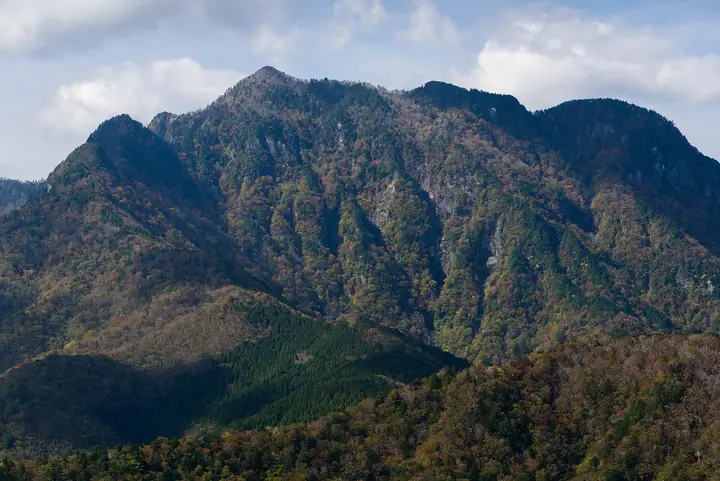
Mount Daifugen (1,780 m) lies in Kamikitayama Village, Nara Prefecture, near the midpoint of the Ōmine Okugake-michi, the historic Shugendō pilgrimage route from Yoshino to Kumano. The ascent threads steep ladder pitches and chained scrambles past Shō-no-Iwaya and other ascetic rock shelters used since medieval times. The peak forms part of the World Heritage "Sacred Sites and Pilgrimage Routes in the Kii Mountain Range" and lies within Yoshino-Kumano National Park, and is listed in the Kansai Hyakumeizan and the Kinki Hyakumeizan.
Mount Daifugen at a glance
- Weather: The most settled day in the next 7 days is Mon, November 9: clear, gusts up to 9 m/s. Fri, Nov 6, Sat, Nov 7: strong wind (gusts up to 21 m/s).
- Route: The shortest is Mount Daifugen–Mount Shichiyo Circuit from Wasamata: about 7 h 17 min, 11.4 km, about 1,230 m of climbing.
Mount Daifugen weather (hourly, 14 days)
Sunrise today 06:17, sunset 17:03
| Tue, 11/3 | Wed, 11/4 | Thu, 11/5 | Fri, 11/6 | Sat, 11/7 | Sun, 11/8 | Mon, 11/9 | Tue, 11/10 | Wed, 11/11 | Thu, 11/12 | Fri, 11/13 | Sat, 11/14 | Sun, 11/15 | Mon, 11/16 | Tue, 11/17 | |||||||||||||||||||||||||||||||||||||||||||||||||||||||||||||||||||||||
|---|---|---|---|---|---|---|---|---|---|---|---|---|---|---|---|---|---|---|---|---|---|---|---|---|---|---|---|---|---|---|---|---|---|---|---|---|---|---|---|---|---|---|---|---|---|---|---|---|---|---|---|---|---|---|---|---|---|---|---|---|---|---|---|---|---|---|---|---|---|---|---|---|---|---|---|---|---|---|---|---|---|---|---|---|---|
| Japan time | 21 | 23 | 1 | 3 | 5 | 7 | 9 | 11 | 13 | 15 | 17 | 19 | 21 | 0 | 3 | 6 | 9 | 12 | 15 | 18 | 21 | 0 | 3 | 6 | 9 | 12 | 15 | 18 | 21 | 0 | 3 | 6 | 9 | 12 | 15 | 18 | 21 | 0 | 3 | 6 | 9 | 12 | 15 | 18 | 21 | 0 | 3 | 6 | 9 | 12 | 15 | 21 | 3 | 9 | 15 | 21 | 3 | 9 | 15 | 21 | 3 | 9 | 15 | 21 | 3 | 9 | 15 | 21 | 3 | 9 | 15 | 21 | 3 | 9 | 15 | 21 | 3 | 9 | 15 | 21 | 3 | 9 | 15 | 21 | |
  | |  |   | |   | |   |   | | |   | | |   | |   | | |   |   | | | | |   | | | | | | |   | | | | | | | | | | | | | | | | | | | | |  | | | | | |   |  | | | | | | | | | | | | | | | | | | | | | | |  | ||
| Temperature | °C | 2° | 2° | 1° | 1° | 1° | 2° | 7° | 9° | 8° | 7° | 6° | 6° | 6° | 6° | 7° | 7° | 10° | 13° | 14° | 9° | 8° | 9° | 9° | 7° | 6° | 9° | 8° | 5° | 3° | 2° | 0° | -1° | 2° | 3° | 3° | -1° | -2° | -2° | -2° | -3° | 1° | 5° | 5° | 0° | 1° | 3° | 4° | 3° | 5° | 7° | 5° | 0° | -1° | 5° | 6° | 1° | -2° | -1° | 2° | -3° | -4° | 2° | 4° | -1° | -3° | 1° | 2° | -3° | -4° | 5° | 8° | -1° | 2° | 7° | 8° | 8° | 8° | 7° | 6° | 1° | -2° | 0° | 4° | -2° |
| Precipitation | mm | 0.9 | 0.4 | 0.3 | 0.2 | 0.4 | 0.2 | 0.4 | 0.4 | 0.2 | 0.2 | 0.5 | 1.7 | 1.8 | 2.4 | 0.7 | 0.8 | 0.3 | 0.3 | 0.2 | 0.3 | 1.1 | 0.3 | 0.2 | 0.1 | 0.9 | 1.2 | 3.2 | 8 | 1.1 | 4.3 | 1.8 | 0.2 | ||||||||||||||||||||||||||||||||||||||||||||||||||||
| New snow | cm | ||||||||||||||||||||||||||||||||||||||||||||||||||||||||||||||||||||||||||||||||||||
| Snow depth | cm | 0 | 0 | 0 | 0 | 0 | 0 | 0 | 0 | 0 | 0 | 0 | 0 | 0 | 0 | 0 | 0 | 0 | 0 | 0 | 0 | 0 | 0 | 0 | 0 | 0 | 0 | 0 | 0 | 0 | 0 | 0 | 0 | 0 | 0 | 0 | 0 | 0 | 0 | 0 | 0 | 0 | 0 | 0 | 0 | 0 | 0 | 0 | 0 | 0 | 0 | 0 | 0 | 0 | 0 | 0 | 0 | 0 | 0 | 0 | 0 | 0 | 0 | 0 | 0 | 0 | 0 | 0 | 0 | 0 | 0 | 0 | 0 | 0 | 0 | 0 | 0 | 0 | 0 | 0 | 0 | 0 | 0 | 0 | 0 |
| Wind | m/s | 1 | 1 | 1 | 1 | 1 | 1 | 1 | 1 | 2 | 3 | 2 | 3 | 3 | 2 | 2 | 0 | 1 | 1 | 1 | 1 | 3 | 3 | 3 | 4 | 4 | 5 | 5 | 4 | 4 | 4 | 4 | 4 | 5 | 6 | 7 | 5 | 4 | 4 | 4 | 3 | 2 | 3 | 2 | 1 | 1 | 1 | 1 | 1 | 2 | 2 | 2 | 0 | 0 | 1 | 3 | 3 | 5 | 6 | 7 | 3 | 1 | 2 | 2 | 0 | 1 | 4 | 5 | 2 | 0 | 1 | 1 | 1 | 2 | 3 | 3 | 5 | 2 | 3 | 5 | 5 | 2 | 2 | 2 | 0 |
| Wind gusts | m/s | 5 | 4 | 4 | 5 | 5 | 5 | 5 | 5 | 8 | 9 | 8 | 9 | 10 | 10 | 7 | 6 | 5 | 4 | 6 | 5 | 11 | 13 | 15 | 13 | 13 | 14 | 17 | 16 | 15 | 15 | 15 | 15 | 17 | 18 | 21 | 20 | 15 | 14 | 13 | 13 | 11 | 9 | 9 | 7 | 5 | 7 | 6 | 4 | 6 | 9 | 9 | 8 | 4 | 5 | 10 | 11 | 18 | 21 | 22 | 19 | 10 | 6 | 8 | 7 | 8 | 13 | 16 | 14 | 8 | 6 | 6 | 6 | 8 | 11 | 12 | 17 | 17 | 11 | 15 | 16 | 15 | 8 | 8 | 7 |
| Wind dir. | ↓ | ↓ | ↓ | ↓ | ↓ | ↓ | ↓ | ↓ | ↓ | ↓ | ↓ | ↓ | ↓ | ↓ | ↓ | ↓ | ↓ | ↓ | ↓ | ↓ | ↓ | ↓ | ↓ | ↓ | ↓ | ↓ | ↓ | ↓ | ↓ | ↓ | ↓ | ↓ | ↓ | ↓ | ↓ | ↓ | ↓ | ↓ | ↓ | ↓ | ↓ | ↓ | ↓ | ↓ | ↓ | ↓ | ↓ | ↓ | ↓ | ↓ | ↓ | ↓ | ↓ | ↓ | ↓ | ↓ | ↓ | ↓ | ↓ | ↓ | ↓ | ↓ | ↓ | ↓ | ↓ | ↓ | ↓ | ↓ | ↓ | ↓ | ↓ | ↓ | ↓ | ↓ | ↓ | ↓ | ↓ | ↓ | ↓ | ↓ | ↓ | ↓ | ↓ | ↓ | |
Mount Daifugen hiking routes
Hiking times are estimates calculated from the terrain.
Huts, campsites and lodging near Mount Daifugen
Mountain huts
Lists that include Mount Daifugen
Kansai 100 Famous Mountains · Kinki 100 Famous Mountains · Nara 100 Mountains to Explore · Ōmine Okugakemichi · Elevations of 1003 Mountains of Japan · 1000 Mountains of Japan
Mount Daifugen facts
- Elevation
- 1,780 m
- Location
- Tenkawa, Nara / Kamikitayama, Nara / Kawakami, Nara
34.227868, 135.962822 - National Park
- 吉野熊野国立公園
- Website
- www.vill.kamikitayama.nara.jp
- Trail Map
- www.vill.kamikitayama.nara.jp
- Wikipedia
- ja.wikipedia.org