
Mt. Inamura
稲村ヶ岳
Tenkawa, Nara · Elevation 1,726 m
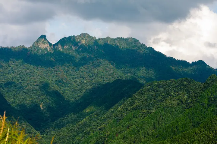
Mt. Inamura (1,726 m) rises in Tenkawa Village, Yoshino District, Nara, the only freestanding peak in the Ōmine Range and within Yoshino-Kumano National Park. Because the neighbouring Mt. Sanjō remains a women-prohibited Shugendō site, Mt. Inamura has long been known as the "Women's Ōmine" and has welcomed female ascetics since the modern era. The standard route climbs from Dorogawa Onsen via Hahako-dō and the Sanjō-Tsuji col, where the Inamuragatake Sansō hut operates on weekends from late April through late November. The summit lookout commands a sweeping panorama of the Ōmine Okugake-michi pilgrim ridge, and the mountain is loved year-round for its mitsuba azaleas and rhododendrons in May–June and the rare Ōyamarengē in July.
Mt. Inamura at a glance
- Weather: The most settled day in the next 7 days is Mon, November 9: clear, gusts up to 10 m/s. Fri, Nov 6, Sat, Nov 7: strong wind (gusts up to 19 m/s).
- Route: The shortest is Mount Dainichi and Mount Inamuragatake Return from Hahakodo: about 7 h 39 min, 12.7 km, about 1,000 m of climbing.
Mt. Inamura weather (hourly, 14 days)
Sunrise today 06:17, sunset 17:03
| Tue, 11/3 | Wed, 11/4 | Thu, 11/5 | Fri, 11/6 | Sat, 11/7 | Sun, 11/8 | Mon, 11/9 | Tue, 11/10 | Wed, 11/11 | Thu, 11/12 | Fri, 11/13 | Sat, 11/14 | Sun, 11/15 | Mon, 11/16 | Tue, 11/17 | |||||||||||||||||||||||||||||||||||||||||||||||||||||||||||||||||||||||
|---|---|---|---|---|---|---|---|---|---|---|---|---|---|---|---|---|---|---|---|---|---|---|---|---|---|---|---|---|---|---|---|---|---|---|---|---|---|---|---|---|---|---|---|---|---|---|---|---|---|---|---|---|---|---|---|---|---|---|---|---|---|---|---|---|---|---|---|---|---|---|---|---|---|---|---|---|---|---|---|---|---|---|---|---|---|
| Japan time | 15 | 17 | 19 | 21 | 23 | 1 | 3 | 5 | 7 | 9 | 11 | 13 | 15 | 18 | 21 | 0 | 3 | 6 | 9 | 12 | 15 | 18 | 21 | 0 | 3 | 6 | 9 | 12 | 15 | 18 | 21 | 0 | 3 | 6 | 9 | 12 | 15 | 18 | 21 | 0 | 3 | 6 | 9 | 12 | 15 | 18 | 21 | 0 | 3 | 6 | 9 | 15 | 21 | 3 | 9 | 15 | 21 | 3 | 9 | 15 | 21 | 3 | 9 | 15 | 21 | 3 | 9 | 15 | 21 | 3 | 9 | 15 | 21 | 3 | 9 | 15 | 21 | 3 | 9 | 15 | 21 | 3 | 9 | 15 | |
  | |   |   | | | | | |   |   | |   |   | | | |   | |   | | | | | | | | | |   | |   | | | | | | | | | | | | | | | | | | |  | | | | | | | |   | |   |  | | | | | | | | | | | | | | | | | | | | | | | ||
| Temperature | °C | 8° | 5° | 3° | 3° | 2° | 2° | 2° | 1° | 2° | 8° | 11° | 10° | 8° | 6° | 6° | 7° | 7° | 7° | 11° | 13° | 13° | 9° | 8° | 8° | 10° | 8° | 7° | 9° | 9° | 6° | 3° | 2° | 0° | -1° | 2° | 2° | 3° | 0° | -2° | -3° | -2° | -2° | 3° | 6° | 5° | 0° | 1° | 1° | 1° | 1° | 6° | 6° | 0° | 0° | 5° | 6° | 1° | -2° | -1° | 2° | -3° | -4° | 2° | 5° | -1° | -2° | 1° | 3° | -3° | -3° | 5° | 9° | -1° | 2° | 7° | 8° | 8° | 9° | 8° | 6° | 1° | -2° | 0° | 5° |
| Precipitation | mm | 0.1 | 0.3 | 0.3 | 0.3 | 0.1 | 0.8 | 0.4 | 0.3 | 3.1 | 1.1 | 1.0 | 0.1 | 0.1 | 0.3 | 0.4 | 0.3 | 1.1 | 0.3 | 0.2 | 0.1 | 0.9 | 1.2 | 3.2 | 8 | 1.1 | 4.3 | 1.8 | 0.2 | ||||||||||||||||||||||||||||||||||||||||||||||||||||||||
| New snow | cm | ||||||||||||||||||||||||||||||||||||||||||||||||||||||||||||||||||||||||||||||||||||
| Snow depth | cm | 0 | 0 | 0 | 0 | 0 | 0 | 0 | 0 | 0 | 0 | 0 | 0 | 0 | 0 | 0 | 0 | 0 | 0 | 0 | 0 | 0 | 0 | 0 | 0 | 0 | 0 | 0 | 0 | 0 | 0 | 0 | 0 | 0 | 0 | 0 | 0 | 0 | 0 | 0 | 0 | 0 | 0 | 0 | 0 | 0 | 0 | 0 | 0 | 0 | 0 | 0 | 0 | 0 | 0 | 0 | 0 | 0 | 0 | 0 | 0 | 0 | 0 | 0 | 0 | 0 | 0 | 0 | 0 | 0 | 0 | 0 | 0 | 0 | 0 | 0 | 0 | 0 | 0 | 0 | 0 | 0 | 0 | 0 | 0 |
| Wind | m/s | 3 | 1 | 1 | 1 | 1 | 1 | 2 | 1 | 1 | 1 | 2 | 2 | 3 | 3 | 3 | 2 | 2 | 1 | 1 | 1 | 1 | 1 | 2 | 2 | 3 | 4 | 3 | 4 | 5 | 4 | 4 | 4 | 4 | 4 | 6 | 6 | 6 | 4 | 3 | 2 | 3 | 3 | 3 | 3 | 2 | 1 | 0 | 0 | 0 | 0 | 2 | 2 | 0 | 0 | 1 | 3 | 3 | 5 | 6 | 7 | 3 | 1 | 2 | 2 | 0 | 1 | 4 | 5 | 2 | 0 | 1 | 1 | 1 | 2 | 3 | 3 | 5 | 2 | 3 | 5 | 5 | 2 | 2 | 2 |
| Wind gusts | m/s | 9 | 8 | 5 | 5 | 4 | 4 | 5 | 6 | 5 | 5 | 7 | 7 | 8 | 9 | 10 | 11 | 9 | 8 | 5 | 5 | 5 | 5 | 8 | 10 | 13 | 12 | 14 | 14 | 16 | 15 | 14 | 15 | 15 | 15 | 18 | 19 | 19 | 17 | 14 | 12 | 11 | 12 | 11 | 11 | 9 | 8 | 4 | 3 | 3 | 4 | 7 | 10 | 8 | 4 | 5 | 10 | 11 | 18 | 21 | 22 | 19 | 10 | 6 | 8 | 7 | 8 | 13 | 16 | 14 | 8 | 6 | 6 | 6 | 8 | 11 | 12 | 17 | 17 | 11 | 15 | 16 | 15 | 8 | 8 |
| Wind dir. | ↓ | ↓ | ↓ | ↓ | ↓ | ↓ | ↓ | ↓ | ↓ | ↓ | ↓ | ↓ | ↓ | ↓ | ↓ | ↓ | ↓ | ↓ | ↓ | ↓ | ↓ | ↓ | ↓ | ↓ | ↓ | ↓ | ↓ | ↓ | ↓ | ↓ | ↓ | ↓ | ↓ | ↓ | ↓ | ↓ | ↓ | ↓ | ↓ | ↓ | ↓ | ↓ | ↓ | ↓ | ↓ | ↓ | ↓ | ↓ | ↓ | ↓ | ↓ | ↓ | ↓ | ↓ | ↓ | ↓ | ↓ | ↓ | ↓ | ↓ | ↓ | ↓ | ↓ | ↓ | ↓ | ↓ | ↓ | ↓ | ↓ | ↓ | ↓ | ↓ | ↓ | ↓ | ↓ | ↓ | ↓ | ↓ | ↓ | ↓ | ↓ | ↓ | ↓ | ↓ | |
Mt. Inamura hiking routes
- Mount Dainichi and Mount Inamuragatake Return from Hahakodo 12.7 km · Ascent 1,001 m ごろごろ茶屋 (parking)
- Tenkawa Omine Sanjogatake to Inamuragatake, the Women's Omine, Loop by Dorotsuji, Renge-tsuji and Horiki Pass 16.2 km · Ascent 1,237 m
Hiking times are estimates calculated from the terrain.
Huts, campsites and lodging near Mt. Inamura
Mountain huts
- 稲村ヶ岳山荘 2026: open April 25–November 25 · reservation required · sleeps 20
- 宿坊 櫻本坊
- 宿坊 龍泉寺
- 宿坊 竹林院
- 小笹ノ宿避難小屋 unstaffed
Campsites
- 白の平オートキャンプ場
- 松林オートキャンプ場
Lodging
- 彰武
Lists that include Mt. Inamura
Kansai 100 Famous Mountains · Kinki 100 Famous Mountains · Nara 100 Mountains to Explore · 1000 Mountains of Japan
Mt. Inamura facts
- Also known as
- 女人大峯
- Elevation
- 1,726 m
- Location
- Tenkawa, Nara
34.237648, 135.923640 - National Park
- 吉野熊野国立公園
- Website
- www.vill.tenkawa.nara.jp
- Trail Map
- www.vill.tenkawa.nara.jp (PDF)
- Wikipedia
- ja.wikipedia.org