
Mt. Kyuushouzan
久松山
Tottori, Tottori · Elevation 263 m
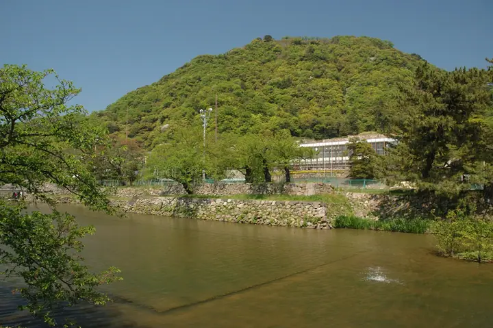
Mt. Kyuushouzan is a 263 m peak rising east of central Tottori City; the ruins of Tottori Castle, originally a Sengoku-period mountain castle, occupy the summit and slopes. Praised by Oda Nobunaga as a "famed and impregnable castle" and the site of Hashiba Hideyoshi's notorious starvation siege, it is now a nationally designated historic site, with Kyusho Park at its base ranked among the prefecture's foremost cherry-blossom and autumn-foliage spots. From the park, the Ninomaru bailey is a 10-minute walk and the summit Sanjo-no-maru about 40 minutes. The peak is included in the China 100 Mountains, the China-region 100 Mountains, and the Tottori Prefecture mountains guidebook.
Mt. Kyuushouzan at a glance
- Weather: The most settled day in the next 7 days is Wed, November 4: clear, gusts up to 12 m/s. Fri, Nov 6, Sat, Nov 7: strong wind (gusts up to 18 m/s).
- Route: The shortest is Tottori Castle Ruins Return from the Ninomaru to the Sanjonomaru: about 1 h 25 min, 2.4 km, about 250 m of climbing.
Mt. Kyuushouzan weather (hourly, 14 days)
Sunrise today 06:26, sunset 17:07
| Tue, 11/3 | Wed, 11/4 | Thu, 11/5 | Fri, 11/6 | Sat, 11/7 | Sun, 11/8 | Mon, 11/9 | Tue, 11/10 | Wed, 11/11 | Thu, 11/12 | Fri, 11/13 | Sat, 11/14 | Sun, 11/15 | Mon, 11/16 | Tue, 11/17 | |||||||||||||||||||||||||||||||||||||||||||||||||||||||||||||||||||||||
|---|---|---|---|---|---|---|---|---|---|---|---|---|---|---|---|---|---|---|---|---|---|---|---|---|---|---|---|---|---|---|---|---|---|---|---|---|---|---|---|---|---|---|---|---|---|---|---|---|---|---|---|---|---|---|---|---|---|---|---|---|---|---|---|---|---|---|---|---|---|---|---|---|---|---|---|---|---|---|---|---|---|---|---|---|---|
| Japan time | 15 | 17 | 19 | 21 | 23 | 1 | 3 | 5 | 7 | 9 | 11 | 13 | 15 | 18 | 21 | 0 | 3 | 6 | 9 | 12 | 15 | 18 | 21 | 0 | 3 | 6 | 9 | 12 | 15 | 18 | 21 | 0 | 3 | 6 | 9 | 12 | 15 | 18 | 21 | 0 | 3 | 6 | 9 | 12 | 15 | 18 | 21 | 0 | 3 | 6 | 9 | 15 | 21 | 3 | 9 | 15 | 21 | 3 | 9 | 15 | 21 | 3 | 9 | 15 | 21 | 3 | 9 | 15 | 21 | 3 | 9 | 15 | 21 | 3 | 9 | 15 | 21 | 3 | 9 | 15 | 21 | 3 | 9 | 15 | |
  |   |   |   |   |   | |   |   | |  | | | | | | | | | |   | | | | | | | |   | |   | | | | | | | | | | | |   | | | | | | | | | | | | | | | | | | | | | | | | | | |  | | | | | | | | | | | | | | | ||
| Temperature | °C | 15° | 14° | 13° | 13° | 12° | 11° | 11° | 10° | 11° | 15° | 17° | 17° | 17° | 15° | 13° | 13° | 13° | 13° | 16° | 18° | 16° | 15° | 15° | 15° | 16° | 15° | 16° | 17° | 16° | 15° | 13° | 13° | 13° | 12° | 12° | 13° | 13° | 13° | 13° | 12° | 12° | 11° | 14° | 15° | 14° | 13° | 12° | 11° | 11° | 12° | 12° | 15° | 10° | 9° | 12° | 14° | 11° | 11° | 12° | 12° | 12° | 10° | 12° | 15° | 12° | 11° | 13° | 12° | 11° | 7° | 12° | 15° | 9° | 13° | 15° | 15° | 16° | 15° | 15° | 13° | 11° | 10° | 11° | 11° |
| Precipitation | mm | 0.4 | 0.1 | 0.2 | 0.1 | 0.1 | 0.4 | 2.3 | 2.9 | 0.4 | 6 | 1.3 | 1.0 | 1.5 | 1.3 | 0.4 | 0.3 | 0.3 | 0.2 | 1.6 | 6 | 9 | 1.4 | 1.2 | 0.3 | 3.1 | 1.5 | 1.0 | 0.7 | 0.3 | 0.1 | 2.0 | 1.1 | 2.0 | 9 | 4.3 | 4.9 | 3.4 | 0.4 | ||||||||||||||||||||||||||||||||||||||||||||||
| New snow | cm | ||||||||||||||||||||||||||||||||||||||||||||||||||||||||||||||||||||||||||||||||||||
| Snow depth | cm | 0 | 0 | 0 | 0 | 0 | 0 | 0 | 0 | 0 | 0 | 0 | 0 | 0 | 0 | 0 | 0 | 0 | 0 | 0 | 0 | 0 | 0 | 0 | 0 | 0 | 0 | 0 | 0 | 0 | 0 | 0 | 0 | 0 | 0 | 0 | 0 | 0 | 0 | 0 | 0 | 0 | 0 | 0 | 0 | 0 | 0 | 0 | 0 | 0 | 0 | 0 | 0 | 0 | 0 | 0 | 0 | 0 | 0 | 0 | 0 | 0 | 0 | 0 | 0 | 0 | 0 | 0 | 0 | 0 | 0 | 0 | 0 | 0 | 0 | 0 | 0 | 0 | 0 | 0 | 0 | 0 | 0 | 0 | 0 |
| Wind | m/s | 4 | 3 | 3 | 2 | 1 | 1 | 2 | 2 | 2 | 3 | 4 | 6 | 6 | 4 | 2 | 1 | 2 | 2 | 1 | 1 | 0 | 2 | 2 | 1 | 6 | 6 | 5 | 8 | 8 | 8 | 8 | 8 | 8 | 9 | 8 | 8 | 6 | 5 | 4 | 3 | 3 | 2 | 1 | 4 | 3 | 3 | 1 | 1 | 2 | 2 | 3 | 5 | 1 | 1 | 2 | 6 | 8 | 9 | 6 | 5 | 3 | 1 | 3 | 4 | 3 | 4 | 6 | 5 | 4 | 2 | 1 | 4 | 3 | 4 | 4 | 6 | 6 | 4 | 5 | 10 | 6 | 3 | 4 | 3 |
| Wind gusts | m/s | 10 | 9 | 6 | 4 | 3 | 3 | 4 | 4 | 4 | 6 | 9 | 11 | 12 | 12 | 7 | 4 | 4 | 5 | 5 | 4 | 4 | 3 | 5 | 3 | 10 | 12 | 10 | 16 | 18 | 14 | 16 | 16 | 15 | 16 | 18 | 17 | 15 | 12 | 9 | 8 | 6 | 5 | 4 | 9 | 10 | 6 | 6 | 3 | 3 | 5 | 7 | 11 | 10 | 4 | 6 | 16 | 16 | 21 | 17 | 14 | 11 | 5 | 7 | 9 | 11 | 6 | 14 | 13 | 11 | 6 | 6 | 9 | 9 | 8 | 8 | 11 | 18 | 11 | 12 | 18 | 18 | 12 | 8 | 9 |
| Wind dir. | ↓ | ↓ | ↓ | ↓ | ↓ | ↓ | ↓ | ↓ | ↓ | ↓ | ↓ | ↓ | ↓ | ↓ | ↓ | ↓ | ↓ | ↓ | ↓ | ↓ | ↓ | ↓ | ↓ | ↓ | ↓ | ↓ | ↓ | ↓ | ↓ | ↓ | ↓ | ↓ | ↓ | ↓ | ↓ | ↓ | ↓ | ↓ | ↓ | ↓ | ↓ | ↓ | ↓ | ↓ | ↓ | ↓ | ↓ | ↓ | ↓ | ↓ | ↓ | ↓ | ↓ | ↓ | ↓ | ↓ | ↓ | ↓ | ↓ | ↓ | ↓ | ↓ | ↓ | ↓ | ↓ | ↓ | ↓ | ↓ | ↓ | ↓ | ↓ | ↓ | ↓ | ↓ | ↓ | ↓ | ↓ | ↓ | ↓ | ↓ | ↓ | ↓ | ↓ | ↓ | |
Mt. Kyuushouzan hiking routes
Hiking times are estimates calculated from the terrain.
Huts, campsites and lodging near Mt. Kyuushouzan
Mountain huts
- 一時避難所
Campsites
- Yanagijaya Camping Ground
Lodging
- とらや旅館
- 鳥取シティホテル
- 白兎会館
- ホテル α-1
- ホテルモナーク鳥取
Lists that include Mt. Kyuushouzan
Mt. Kyuushouzan facts
- Elevation
- 263 m
- Location
- Tottori, Tottori
35.510313, 134.240769 - Website
- www.city.tottori.lg.jp
- Trail Map
- www.city.tottori.lg.jp (PDF)
- Access Information
- www.torican.jp
- Wikipedia
- ja.wikipedia.org