
Mt. Komochiyama
子持山
Shibukawa, Gunma · Elevation 1,296 m
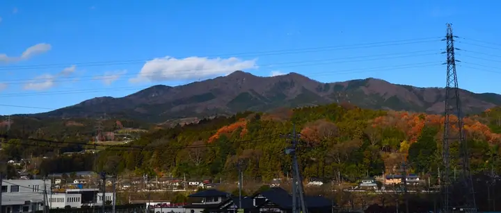
Mt. Komochiyama is a 1,296.1-meter stratovolcano of the Nasu volcanic zone, straddling Shibukawa City, Numata City, and Takayama Village in Gunma Prefecture. Active some 500,000-600,000 years ago, long erosion has exposed the volcano's interior, leaving behind dramatic features such as the 100-meter "Shishi-iwa" (Lion Rock) volcanic plug and the cliffs of Byobu-iwa. The summit sits on the boundary between Shibukawa and Numata, and six maintained trails climb the mountain — the most popular leaving from Komochi Shrine and traversing Asamagata. The peak is featured in the Gunma Hyakumeizan, Kanto Hyakumeizan, and Nihon Hyaku Teizan lists.
Mt. Komochiyama at a glance
- Weather: The most settled day in the next 7 days is Mon, November 9: clear, gusts up to 5 m/s. Sun, Nov 8: strong wind (gusts up to 16 m/s).
- Route: The shortest is Mount Komochi Loop from Bridge No. 7 via Byobu Rock and Shishi Rock over Yanagigamine: about 3 h 18 min, 4.8 km, about 620 m of climbing.
Mt. Komochiyama weather (hourly, 14 days)
Sunrise today 06:09, sunset 16:47
| Tue, 11/3 | Wed, 11/4 | Thu, 11/5 | Fri, 11/6 | Sat, 11/7 | Sun, 11/8 | Mon, 11/9 | Tue, 11/10 | Wed, 11/11 | Thu, 11/12 | Fri, 11/13 | Sat, 11/14 | Sun, 11/15 | Mon, 11/16 | Tue, 11/17 | |||||||||||||||||||||||||||||||||||||||||||||||||||||||||||||||||||||||
|---|---|---|---|---|---|---|---|---|---|---|---|---|---|---|---|---|---|---|---|---|---|---|---|---|---|---|---|---|---|---|---|---|---|---|---|---|---|---|---|---|---|---|---|---|---|---|---|---|---|---|---|---|---|---|---|---|---|---|---|---|---|---|---|---|---|---|---|---|---|---|---|---|---|---|---|---|---|---|---|---|---|---|---|---|---|
| Japan time | 15 | 17 | 19 | 21 | 23 | 1 | 3 | 5 | 7 | 9 | 11 | 13 | 15 | 18 | 21 | 0 | 3 | 6 | 9 | 12 | 15 | 18 | 21 | 0 | 3 | 6 | 9 | 12 | 15 | 18 | 21 | 0 | 3 | 6 | 9 | 12 | 15 | 18 | 21 | 0 | 3 | 6 | 9 | 12 | 15 | 18 | 21 | 0 | 3 | 6 | 9 | 15 | 21 | 3 | 9 | 15 | 21 | 3 | 9 | 15 | 21 | 3 | 9 | 15 | 21 | 3 | 9 | 15 | 21 | 3 | 9 | 15 | 21 | 3 | 9 | 15 | 21 | 3 | 9 | 15 | 21 | 3 | 9 | 15 | |
  |  |   | | | | | | |  | | | |   |   | | | |   |   | | | | |   | | | | | | | | | | | | | | | | | | | | | | | | | | | | | | | | |   | | | | | |   | | |   | | |  | | | | | | | |   | | | | | | | ||
| Temperature | °C | 8° | 4° | 3° | 0° | -1° | -2° | -2° | -3° | -2° | 6° | 9° | 9° | 7° | 4° | 4° | 3° | 3° | 4° | 6° | 8° | 10° | 7° | 6° | 5° | 4° | 3° | 11° | 15° | 12° | 7° | 6° | 4° | 3° | 2° | 4° | 6° | 4° | 0° | 0° | -1° | 0° | -1° | 3° | 5° | 4° | 0° | -2° | -2° | -1° | -1° | 3° | 4° | 2° | 0° | 1° | 4° | 1° | -1° | 2° | 2° | 0° | -1° | 3° | 5° | 0° | -4° | 3° | 3° | -1° | -3° | 1° | 4° | -3° | -5° | 4° | 7° | 3° | 1° | 8° | 8° | 1° | -2° | 2° | 4° |
| Precipitation | mm | 0.1 | 0.8 | 9 | 8 | 1.5 | 0.4 | 1.0 | 0.3 | 0.3 | 1.2 | 0.6 | 1.3 | 0.3 | 0.2 | 3.5 | 7 | 1.0 | |||||||||||||||||||||||||||||||||||||||||||||||||||||||||||||||||||
| New snow | cm | ||||||||||||||||||||||||||||||||||||||||||||||||||||||||||||||||||||||||||||||||||||
| Snow depth | cm | 0 | 0 | 0 | 0 | 0 | 0 | 0 | 0 | 0 | 0 | 0 | 0 | 0 | 0 | 0 | 0 | 0 | 0 | 0 | 0 | 0 | 0 | 0 | 0 | 0 | 0 | 0 | 0 | 0 | 0 | 0 | 0 | 0 | 0 | 0 | 0 | 0 | 0 | 0 | 0 | 0 | 0 | 0 | 0 | 0 | 0 | 0 | 0 | 0 | 0 | 0 | 0 | 0 | 0 | 0 | 0 | 0 | 0 | 0 | 0 | 0 | 0 | 0 | 0 | 0 | 0 | 0 | 0 | 0 | 0 | 0 | 0 | 0 | 0 | 0 | 0 | 0 | 0 | 0 | 0 | 0 | 0 | 0 | 0 |
| Wind | m/s | 5 | 2 | 2 | 1 | 2 | 1 | 1 | 1 | 2 | 0 | 2 | 3 | 3 | 2 | 1 | 1 | 1 | 2 | 1 | 1 | 1 | 0 | 1 | 1 | 1 | 2 | 2 | 2 | 4 | 3 | 4 | 4 | 4 | 4 | 4 | 4 | 4 | 4 | 3 | 4 | 4 | 3 | 4 | 5 | 5 | 2 | 2 | 1 | 1 | 1 | 1 | 1 | 1 | 1 | 2 | 2 | 1 | 2 | 4 | 3 | 2 | 2 | 1 | 3 | 1 | 2 | 4 | 4 | 2 | 3 | 1 | 2 | 1 | 1 | 1 | 1 | 1 | 2 | 2 | 5 | 4 | 3 | 0 | 3 |
| Wind gusts | m/s | 14 | 12 | 6 | 4 | 4 | 4 | 4 | 4 | 4 | 4 | 6 | 8 | 9 | 8 | 5 | 3 | 3 | 4 | 5 | 5 | 3 | 3 | 3 | 3 | 4 | 5 | 7 | 8 | 12 | 11 | 10 | 12 | 12 | 11 | 12 | 13 | 12 | 13 | 10 | 10 | 11 | 11 | 11 | 14 | 16 | 13 | 5 | 4 | 4 | 4 | 4 | 5 | 4 | 3 | 5 | 7 | 7 | 8 | 14 | 16 | 13 | 7 | 6 | 8 | 8 | 4 | 12 | 14 | 12 | 9 | 9 | 7 | 6 | 3 | 4 | 6 | 4 | 5 | 6 | 15 | 16 | 12 | 9 | 7 |
| Wind dir. | ↓ | ↓ | ↓ | ↓ | ↓ | ↓ | ↓ | ↓ | ↓ | ↓ | ↓ | ↓ | ↓ | ↓ | ↓ | ↓ | ↓ | ↓ | ↓ | ↓ | ↓ | ↓ | ↓ | ↓ | ↓ | ↓ | ↓ | ↓ | ↓ | ↓ | ↓ | ↓ | ↓ | ↓ | ↓ | ↓ | ↓ | ↓ | ↓ | ↓ | ↓ | ↓ | ↓ | ↓ | ↓ | ↓ | ↓ | ↓ | ↓ | ↓ | ↓ | ↓ | ↓ | ↓ | ↓ | ↓ | ↓ | ↓ | ↓ | ↓ | ↓ | ↓ | ↓ | ↓ | ↓ | ↓ | ↓ | ↓ | ↓ | ↓ | ↓ | ↓ | ↓ | ↓ | ↓ | ↓ | ↓ | ↓ | ↓ | ↓ | ↓ | ↓ | ↓ | ↓ | |
Mt. Komochiyama hiking routes
- Mount Komochi Loop from Bridge No. 7 via Byobu Rock and Shishi Rock over Yanagigamine 4.8 km · Ascent 617 m 7号橋駐車場
- Mount Komochi and Sengenyama Loop from Bridge No. 5 6.4 km · Ascent 824 m 5号橋駐車場, 6号橋駐車場
Hiking times are estimates calculated from the terrain.
Huts, campsites and lodging near Mt. Komochiyama
Campsites
- みどりの村
- ブルーサミット オートキャンプ場
Lists that include Mt. Komochiyama
100 Low Mountains of Japan · Kanto 100 Famous Mountains · Gunma 100 Famous Mountains · Elevations of 1003 Mountains of Japan · 1000 Mountains of Japan
Mt. Komochiyama facts
- Elevation
- 1,296 m
- Location
- Shibukawa, Gunma
36.591941, 138.997613 - Website
- www.city.shibukawa.lg.jp
- Trail Map
- www.numata-kankou.jp (PDF)
- Wikipedia
- ja.wikipedia.org