
Mt. Kawanori
川乗山
Okutama, Tokyo · Elevation 1,363 m
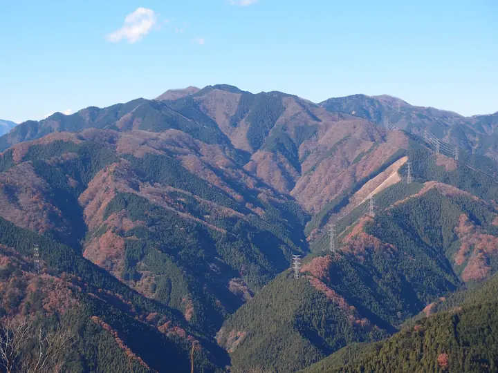
Mt. Kawanori (1,363 m) rises in Okutama Town in western Tokyo as one of the most popular peaks of the Okutama region, within Chichibu-Tama-Kai National Park. Its name ("river-moss mountain") comes from the edible kawa-nori once gathered in its valleys; topographic maps also write it as "Kawanori-yama." The route up from the Kawanori-bashi bus stop along the Hyakuhiro stream, past the 40-metre Hyakuhiro Falls, is a varied valley climb that draws weekend crowds and earned the peak a place on Sumie Tanaka's "100 Flower Mountains." From the summit hikers look out to Mt. Kumotori, the wider Okutama range, and Mt. Fuji. It is counted among the 100 Famous Mountains of Kantō, the 100 Low Mountains of Japan, and the 100 Mountains of Tokyo.
Mt. Kawanori at a glance
- Weather: The most settled day in the next 7 days is Mon, November 9: cloudy, gusts up to 5 m/s.
Mt. Kawanori weather (hourly, 14 days)
Sunrise today 06:07, sunset 16:47
| Tue, 11/3 | Wed, 11/4 | Thu, 11/5 | Fri, 11/6 | Sat, 11/7 | Sun, 11/8 | Mon, 11/9 | Tue, 11/10 | Wed, 11/11 | Thu, 11/12 | Fri, 11/13 | Sat, 11/14 | Sun, 11/15 | Mon, 11/16 | Tue, 11/17 | |||||||||||||||||||||||||||||||||||||||||||||||||||||||||||||||||||||||
|---|---|---|---|---|---|---|---|---|---|---|---|---|---|---|---|---|---|---|---|---|---|---|---|---|---|---|---|---|---|---|---|---|---|---|---|---|---|---|---|---|---|---|---|---|---|---|---|---|---|---|---|---|---|---|---|---|---|---|---|---|---|---|---|---|---|---|---|---|---|---|---|---|---|---|---|---|---|---|---|---|---|---|---|---|---|
| Japan time | 21 | 23 | 1 | 3 | 5 | 7 | 9 | 11 | 13 | 15 | 17 | 19 | 21 | 0 | 3 | 6 | 9 | 12 | 15 | 18 | 21 | 0 | 3 | 6 | 9 | 12 | 15 | 18 | 21 | 0 | 3 | 6 | 9 | 12 | 15 | 18 | 21 | 0 | 3 | 6 | 9 | 12 | 15 | 18 | 21 | 0 | 3 | 6 | 9 | 12 | 15 | 21 | 3 | 9 | 15 | 21 | 3 | 9 | 15 | 21 | 3 | 9 | 15 | 21 | 3 | 9 | 15 | 21 | 3 | 9 | 15 | 21 | 3 | 9 | 15 | 21 | 3 | 9 | 15 | 21 | 3 | 9 | 15 | 21 | |
  | |   | | |   | | |   | | | | | | | | |   |   |   | |  | | |  | | | | | | | | |   |   | | | | | | | | | | | | | | | | | | | | |   | | | |   |  | | | | | | | | | | | | | | | |   | | | | | | | | ||
| Temperature | °C | 5° | 5° | 4° | 4° | 4° | 4° | 5° | 6° | 5° | 4° | 4° | 4° | 4° | 4° | 4° | 5° | 8° | 12° | 11° | 8° | 6° | 5° | 6° | 5° | 13° | 15° | 13° | 8° | 7° | 5° | 2° | 1° | 7° | 8° | 7° | 1° | -1° | -2° | -2° | -2° | 5° | 7° | 6° | 3° | 1° | 1° | 1° | 1° | 2° | 3° | 3° | 2° | 1° | 2° | 4° | 1° | -3° | 4° | 5° | -2° | -3° | 4° | 4° | 2° | -1° | 7° | 6° | -3° | -3° | 2° | 4° | -1° | -1° | 5° | 6° | 5° | 5° | 11° | 12° | 4° | 2° | 1° | 3° | 1° |
| Precipitation | mm | 0.7 | 0.7 | 0.4 | 0.2 | 0.6 | 1.3 | 3.5 | 10 | 16 | 8 | 2.1 | 0.1 | 0.1 | 0.2 | 0.2 | 0.2 | 0.2 | 0.3 | 0.9 | 0.3 | 3.1 | 15 | ||||||||||||||||||||||||||||||||||||||||||||||||||||||||||||||
| New snow | cm | ||||||||||||||||||||||||||||||||||||||||||||||||||||||||||||||||||||||||||||||||||||
| Snow depth | cm | 0 | 0 | 0 | 0 | 0 | 0 | 0 | 0 | 0 | 0 | 0 | 0 | 0 | 0 | 0 | 0 | 0 | 0 | 0 | 0 | 0 | 0 | 0 | 0 | 0 | 0 | 0 | 0 | 0 | 0 | 0 | 0 | 0 | 0 | 0 | 0 | 0 | 0 | 0 | 0 | 0 | 0 | 0 | 0 | 0 | 0 | 0 | 0 | 0 | 0 | 0 | 0 | 0 | 0 | 0 | 0 | 0 | 0 | 0 | 0 | 0 | 0 | 0 | 0 | 0 | 0 | 0 | 0 | 0 | 0 | 0 | 0 | 0 | 0 | 0 | 0 | 0 | 0 | 0 | 0 | 0 | 0 | 0 | 0 |
| Wind | m/s | 1 | 0 | 0 | 1 | 0 | 0 | 1 | 1 | 1 | 1 | 1 | 1 | 2 | 2 | 2 | 3 | 2 | 2 | 1 | 1 | 1 | 0 | 0 | 2 | 1 | 2 | 2 | 1 | 1 | 2 | 2 | 1 | 1 | 3 | 3 | 0 | 1 | 2 | 2 | 2 | 1 | 2 | 1 | 0 | 1 | 1 | 1 | 1 | 1 | 1 | 1 | 1 | 2 | 2 | 3 | 1 | 1 | 8 | 6 | 2 | 1 | 1 | 1 | 1 | 1 | 3 | 6 | 2 | 0 | 1 | 2 | 0 | 0 | 1 | 1 | 0 | 0 | 0 | 6 | 4 | 1 | 1 | 2 | 1 |
| Wind gusts | m/s | 4 | 2 | 2 | 3 | 3 | 2 | 3 | 5 | 5 | 4 | 4 | 3 | 4 | 5 | 5 | 7 | 7 | 9 | 6 | 3 | 4 | 3 | 3 | 5 | 5 | 6 | 7 | 5 | 4 | 6 | 6 | 5 | 4 | 8 | 9 | 9 | 3 | 5 | 5 | 5 | 5 | 6 | 6 | 4 | 2 | 3 | 3 | 3 | 4 | 5 | 5 | 5 | 5 | 5 | 8 | 7 | 4 | 21 | 22 | 15 | 6 | 4 | 8 | 4 | 3 | 8 | 16 | 14 | 5 | 5 | 7 | 6 | 2 | 4 | 6 | 5 | 6 | 4 | 15 | 17 | 11 | 4 | 7 | 5 |
| Wind dir. | ↓ | ↓ | ↓ | ↓ | ↓ | ↓ | ↓ | ↓ | ↓ | ↓ | ↓ | ↓ | ↓ | ↓ | ↓ | ↓ | ↓ | ↓ | ↓ | ↓ | ↓ | ↓ | ↓ | ↓ | ↓ | ↓ | ↓ | ↓ | ↓ | ↓ | ↓ | ↓ | ↓ | ↓ | ↓ | ↓ | ↓ | ↓ | ↓ | ↓ | ↓ | ↓ | ↓ | ↓ | ↓ | ↓ | ↓ | ↓ | ↓ | ↓ | ↓ | ↓ | ↓ | ↓ | ↓ | ↓ | ↓ | ↓ | ↓ | ↓ | ↓ | ↓ | ↓ | ↓ | ↓ | ↓ | ↓ | ↓ | ↓ | ↓ | ↓ | ↓ | ↓ | ↓ | ↓ | ↓ | ↓ | ↓ | ↓ | ↓ | ↓ | ↓ | ↓ | ↓ | |
Huts, campsites and lodging near Mt. Kawanori
Mountain huts
Campsites
- NAKACHAYA
- 奥茶屋キャンプ場
- 百軒茶屋キャンプ場
- 清東園キャンプ場
- 鳩ノ巣バンガロー
Lodging
- 民宿 雲仙屋
- Hatonosu-so Hotel
- 奥多摩温泉郷 観光荘
- 玉翠荘
- 民話の宿 旅館荒澤屋
Lists that include Mt. Kawanori
100 Famous Mountains of Flowers · 100 Low Mountains of Japan · Kanto 100 Famous Mountains · 100 Mountains of Tama · Elevations of 1003 Mountains of Japan · 1000 Mountains of Japan
Mt. Kawanori facts
- Also known as
- 川乗山 · 横ヶ谷ノ頭
- Elevation
- 1,363 m
- Location
- Okutama, Tokyo
35.850805, 139.106886 - National Park
- 秩父多摩甲斐国立公園
- Website
- www.town.okutama.tokyo.jp
- Access Information
- www.okutama.gr.jp
- Wikipedia
- ja.wikipedia.org