
Mt. Iwagoyasan
岩古谷山
Shitara, Aichi · Elevation 807 m
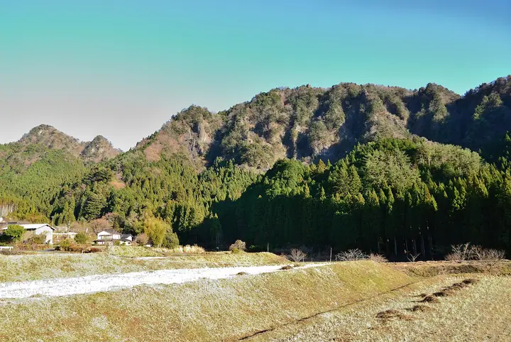
Iwagoyasan (806.9 m) is a rugged rock peak in Shitara Town, Kitashitara District, Aichi Prefecture, formed of lava from a submarine volcano some 20 million years ago. It is counted as one of the three difficult passages on the Tōkai Nature Trail, and from its summit hikers can see the Southern Alps and Mt. Myojin. The peak is easily reached and remains popular year-round, and is also the site of the former Iwagoya Castle. It is included on the Shitara Town "Shitaran Trail" route map.
Mt. Iwagoyasan at a glance
- Weather: The most settled day in the next 7 days is Sun, November 8: clear, gusts up to 7 m/s. Fri, Nov 6, Sat, Nov 7: strong wind (gusts up to 18 m/s).
- Route: The shortest is Shitara Iwagoya Mini Loop from the Tsutsumiishi Tunnel by Tsutsumiishi Pass over the Rocky Summit: about 1 h 36 min, 2.4 km, about 340 m of climbing.
Mt. Iwagoyasan weather (hourly, 14 days)
Sunrise today 06:12, sunset 16:55
| Tue, 11/3 | Wed, 11/4 | Thu, 11/5 | Fri, 11/6 | Sat, 11/7 | Sun, 11/8 | Mon, 11/9 | Tue, 11/10 | Wed, 11/11 | Thu, 11/12 | Fri, 11/13 | Sat, 11/14 | Sun, 11/15 | Mon, 11/16 | Tue, 11/17 | |||||||||||||||||||||||||||||||||||||||||||||||||||||||||||||||||||||||
|---|---|---|---|---|---|---|---|---|---|---|---|---|---|---|---|---|---|---|---|---|---|---|---|---|---|---|---|---|---|---|---|---|---|---|---|---|---|---|---|---|---|---|---|---|---|---|---|---|---|---|---|---|---|---|---|---|---|---|---|---|---|---|---|---|---|---|---|---|---|---|---|---|---|---|---|---|---|---|---|---|---|---|---|---|---|
| Japan time | 15 | 17 | 19 | 21 | 23 | 1 | 3 | 5 | 7 | 9 | 11 | 13 | 15 | 18 | 21 | 0 | 3 | 6 | 9 | 12 | 15 | 18 | 21 | 0 | 3 | 6 | 9 | 12 | 15 | 18 | 21 | 0 | 3 | 6 | 9 | 12 | 15 | 18 | 21 | 0 | 3 | 6 | 9 | 12 | 15 | 18 | 21 | 0 | 3 | 6 | 9 | 15 | 21 | 3 | 9 | 15 | 21 | 3 | 9 | 15 | 21 | 3 | 9 | 15 | 21 | 3 | 9 | 15 | 21 | 3 | 9 | 15 | 21 | 3 | 9 | 15 | 21 | 3 | 9 | 15 | 21 | 3 | 9 | 15 | |
  |   |   | |   | | | | |   | | | |   | | | | |   |   |   | |   | | |   | |  | |  | | | | | | | | | | | | | | | | | | | | | | | | | | | | | | |   | | | |  | | | | | | | | | | | | | | | | | | | | ||
| Temperature | °C | 16° | 11° | 9° | 9° | 7° | 7° | 6° | 6° | 7° | 12° | 14° | 13° | 14° | 12° | 11° | 11° | 11° | 10° | 14° | 19° | 15° | 13° | 12° | 10° | 9° | 12° | 15° | 17° | 16° | 11° | 9° | 8° | 6° | 5° | 9° | 11° | 10° | 6° | 4° | 1° | 0° | 0° | 10° | 13° | 12° | 7° | 7° | 7° | 7° | 5° | 12° | 13° | 4° | 4° | 11° | 12° | 6° | 4° | 7° | 10° | 1° | 2° | 9° | 12° | 2° | 6° | 10° | 11° | 3° | 4° | 9° | 10° | 7° | 9° | 12° | 11° | 10° | 10° | 14° | 16° | 7° | 7° | 10° | 11° |
| Precipitation | mm | 0.7 | 0.3 | 1.2 | 9 | 9 | 1.9 | 0.2 | 0.4 | 0.1 | 0.3 | 0.1 | 0.2 | 0.1 | 0.8 | 4.1 | 20 | 23 | 1.9 | 0.2 | 0.3 | ||||||||||||||||||||||||||||||||||||||||||||||||||||||||||||||||
| New snow | cm | ||||||||||||||||||||||||||||||||||||||||||||||||||||||||||||||||||||||||||||||||||||
| Snow depth | cm | 0 | 0 | 0 | 0 | 0 | 0 | 0 | 0 | 0 | 0 | 0 | 0 | 0 | 0 | 0 | 0 | 0 | 0 | 0 | 0 | 0 | 0 | 0 | 0 | 0 | 0 | 0 | 0 | 0 | 0 | 0 | 0 | 0 | 0 | 0 | 0 | 0 | 0 | 0 | 0 | 0 | 0 | 0 | 0 | 0 | 0 | 0 | 0 | 0 | 0 | 0 | 0 | 0 | 0 | 0 | 0 | 0 | 0 | 0 | 0 | 0 | 0 | 0 | 0 | 0 | 0 | 0 | 0 | 0 | 0 | 0 | 0 | 0 | 0 | 0 | 0 | 0 | 0 | 0 | 0 | 0 | 0 | 0 | 0 |
| Wind | m/s | 1 | 1 | 1 | 2 | 2 | 2 | 2 | 3 | 3 | 2 | 0 | 0 | 0 | 1 | 2 | 1 | 3 | 3 | 2 | 0 | 2 | 1 | 1 | 2 | 2 | 2 | 5 | 6 | 6 | 6 | 6 | 7 | 7 | 6 | 6 | 7 | 7 | 4 | 3 | 3 | 3 | 3 | 1 | 2 | 2 | 0 | 1 | 1 | 2 | 2 | 1 | 4 | 1 | 3 | 1 | 3 | 3 | 7 | 6 | 6 | 3 | 3 | 1 | 1 | 2 | 3 | 3 | 6 | 3 | 3 | 0 | 2 | 2 | 1 | 1 | 2 | 1 | 2 | 3 | 7 | 4 | 2 | 2 | 3 |
| Wind gusts | m/s | 5 | 5 | 3 | 3 | 4 | 4 | 5 | 5 | 5 | 5 | 5 | 3 | 3 | 3 | 5 | 6 | 6 | 8 | 7 | 5 | 8 | 6 | 2 | 4 | 5 | 6 | 12 | 15 | 16 | 15 | 16 | 17 | 17 | 17 | 15 | 18 | 18 | 16 | 11 | 8 | 7 | 7 | 6 | 6 | 7 | 6 | 3 | 3 | 4 | 4 | 4 | 10 | 10 | 5 | 5 | 9 | 8 | 16 | 20 | 16 | 14 | 6 | 6 | 7 | 6 | 9 | 9 | 14 | 14 | 6 | 6 | 5 | 5 | 4 | 4 | 7 | 7 | 9 | 8 | 17 | 17 | 10 | 5 | 8 |
| Wind dir. | ↓ | ↓ | ↓ | ↓ | ↓ | ↓ | ↓ | ↓ | ↓ | ↓ | ↓ | ↓ | ↓ | ↓ | ↓ | ↓ | ↓ | ↓ | ↓ | ↓ | ↓ | ↓ | ↓ | ↓ | ↓ | ↓ | ↓ | ↓ | ↓ | ↓ | ↓ | ↓ | ↓ | ↓ | ↓ | ↓ | ↓ | ↓ | ↓ | ↓ | ↓ | ↓ | ↓ | ↓ | ↓ | ↓ | ↓ | ↓ | ↓ | ↓ | ↓ | ↓ | ↓ | ↓ | ↓ | ↓ | ↓ | ↓ | ↓ | ↓ | ↓ | ↓ | ↓ | ↓ | ↓ | ↓ | ↓ | ↓ | ↓ | ↓ | ↓ | ↓ | ↓ | ↓ | ↓ | ↓ | ↓ | ↓ | ↓ | ↓ | ↓ | ↓ | ↓ | ↓ | |
Mt. Iwagoyasan hiking routes
Hiking times are estimates calculated from the terrain.
Huts, campsites and lodging near Mt. Iwagoyasan
Lodging
- 塩津温泉 秀山荘
- 奥三河総合センター
- 中野屋旅館
- 角屋旅館
- ますや旅館
Lists that include Mt. Iwagoyasan
Tokai 100 Mountains · 130 Mountains of Aichi · 1000 Mountains of Japan
Mt. Iwagoyasan facts
- Also known as
- いわこややま・いわこやさん
- Elevation
- 807 m
- Location
- Shitara, Aichi
35.087239, 137.600482 - Website
- www.kankoshitara.jp
- Trail Map
- www.kankoshitara.jp (PDF)
- Wikipedia
- ja.wikipedia.org