
Mount Myojin
明神山
Tōei-chō, Aichi / Shinshiro, Aichi · Elevation 1,016 m
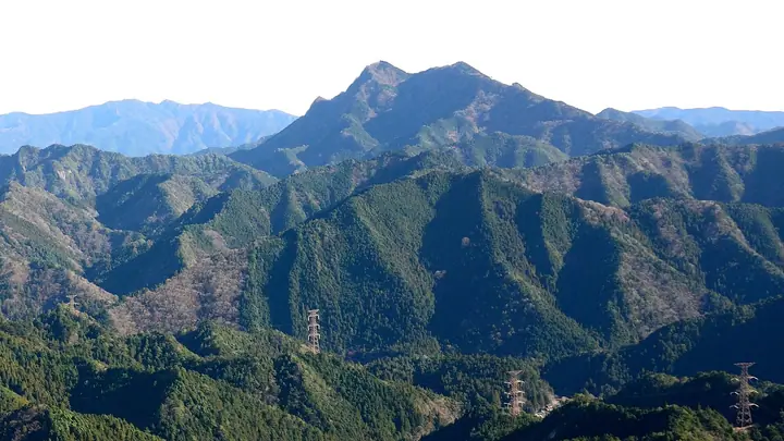
Mount Myojin is a 1,016-meter peak on the border between Toei Town and Shinshiro City in Aichi Prefecture's Kitashitara District, the main summit of the Shitara Mountains. Also known as Mitsuze Myojin-san from the historic faith pilgrimages that climbed it from the Mitsuze hamlet, it presents steep rocky ridges, chains, and knife-edge sections leading to a steel observation tower with 360-degree views. The southern foothills hold Lake Hōraiji and the nationally designated natural monument Chichiiwa Gorge, and the peak is one of the Okumikawa Eight Famous Mountains.
Mount Myojin at a glance
- Weather: The most settled day in the next 7 days is Sun, November 8: clear, gusts up to 7 m/s. Fri, Nov 6, Sat, Nov 7: strong wind (gusts up to 18 m/s).
- Route: The shortest is Toei Mitsuse Myojin, Return on the Old Pilgrim Trail over Uma-no-se Rock to the Lookout Summit: about 4 h 20 min, 6.3 km, about 750 m of climbing.
Mount Myojin weather (hourly, 14 days)
Sunrise today 06:12, sunset 16:54
| Tue, 11/3 | Wed, 11/4 | Thu, 11/5 | Fri, 11/6 | Sat, 11/7 | Sun, 11/8 | Mon, 11/9 | Tue, 11/10 | Wed, 11/11 | Thu, 11/12 | Fri, 11/13 | Sat, 11/14 | Sun, 11/15 | Mon, 11/16 | Tue, 11/17 | |||||||||||||||||||||||||||||||||||||||||||||||||||||||||||||||||||||||
|---|---|---|---|---|---|---|---|---|---|---|---|---|---|---|---|---|---|---|---|---|---|---|---|---|---|---|---|---|---|---|---|---|---|---|---|---|---|---|---|---|---|---|---|---|---|---|---|---|---|---|---|---|---|---|---|---|---|---|---|---|---|---|---|---|---|---|---|---|---|---|---|---|---|---|---|---|---|---|---|---|---|---|---|---|---|
| Japan time | 15 | 17 | 19 | 21 | 23 | 1 | 3 | 5 | 7 | 9 | 11 | 13 | 15 | 18 | 21 | 0 | 3 | 6 | 9 | 12 | 15 | 18 | 21 | 0 | 3 | 6 | 9 | 12 | 15 | 18 | 21 | 0 | 3 | 6 | 9 | 12 | 15 | 18 | 21 | 0 | 3 | 6 | 9 | 12 | 15 | 18 | 21 | 0 | 3 | 6 | 9 | 15 | 21 | 3 | 9 | 15 | 21 | 3 | 9 | 15 | 21 | 3 | 9 | 15 | 21 | 3 | 9 | 15 | 21 | 3 | 9 | 15 | 21 | 3 | 9 | 15 | 21 | 3 | 9 | 15 | 21 | 3 | 9 | 15 | |
  |   |   | |   | | | | |   | | | |   | | | | |   |   |   | |   | | |   | |  | |  | | | | | | | | | | | | | | | | | | | | | | | | | | | | | | |   | | | |  | | | | | | | | | | | | | | | | | | | | ||
| Temperature | °C | 15° | 9° | 8° | 7° | 6° | 6° | 4° | 4° | 5° | 11° | 13° | 12° | 12° | 10° | 9° | 10° | 9° | 9° | 12° | 18° | 13° | 11° | 10° | 8° | 8° | 11° | 13° | 16° | 14° | 10° | 8° | 6° | 5° | 4° | 7° | 10° | 9° | 5° | 2° | 0° | -1° | -2° | 9° | 12° | 11° | 6° | 6° | 6° | 5° | 4° | 11° | 12° | 3° | 3° | 9° | 11° | 5° | 3° | 5° | 8° | 0° | 0° | 8° | 10° | 0° | 5° | 9° | 10° | 1° | 3° | 8° | 9° | 6° | 7° | 11° | 10° | 9° | 9° | 13° | 15° | 6° | 5° | 9° | 9° |
| Precipitation | mm | 0.7 | 0.3 | 1.2 | 9 | 9 | 1.9 | 0.2 | 0.4 | 0.1 | 0.3 | 0.1 | 0.2 | 0.1 | 0.8 | 4.1 | 20 | 23 | 1.9 | 0.2 | 0.3 | ||||||||||||||||||||||||||||||||||||||||||||||||||||||||||||||||
| New snow | cm | ||||||||||||||||||||||||||||||||||||||||||||||||||||||||||||||||||||||||||||||||||||
| Snow depth | cm | 0 | 0 | 0 | 0 | 0 | 0 | 0 | 0 | 0 | 0 | 0 | 0 | 0 | 0 | 0 | 0 | 0 | 0 | 0 | 0 | 0 | 0 | 0 | 0 | 0 | 0 | 0 | 0 | 0 | 0 | 0 | 0 | 0 | 0 | 0 | 0 | 0 | 0 | 0 | 0 | 0 | 0 | 0 | 0 | 0 | 0 | 0 | 0 | 0 | 0 | 0 | 0 | 0 | 0 | 0 | 0 | 0 | 0 | 0 | 0 | 0 | 0 | 0 | 0 | 0 | 0 | 0 | 0 | 0 | 0 | 0 | 0 | 0 | 0 | 0 | 0 | 0 | 0 | 0 | 0 | 0 | 0 | 0 | 0 |
| Wind | m/s | 1 | 1 | 1 | 2 | 2 | 2 | 2 | 3 | 3 | 2 | 0 | 0 | 0 | 1 | 2 | 1 | 3 | 3 | 2 | 0 | 2 | 1 | 1 | 2 | 2 | 2 | 5 | 6 | 6 | 6 | 6 | 7 | 7 | 6 | 6 | 7 | 7 | 4 | 3 | 3 | 3 | 3 | 1 | 2 | 2 | 0 | 1 | 1 | 2 | 2 | 1 | 4 | 1 | 3 | 1 | 3 | 3 | 7 | 6 | 6 | 3 | 3 | 1 | 1 | 2 | 3 | 3 | 6 | 3 | 3 | 0 | 2 | 2 | 1 | 1 | 2 | 1 | 2 | 3 | 7 | 4 | 2 | 2 | 3 |
| Wind gusts | m/s | 5 | 5 | 3 | 3 | 4 | 4 | 5 | 5 | 5 | 5 | 5 | 3 | 3 | 3 | 5 | 6 | 6 | 8 | 7 | 5 | 8 | 6 | 2 | 4 | 5 | 6 | 12 | 15 | 16 | 15 | 16 | 17 | 17 | 17 | 15 | 18 | 18 | 16 | 11 | 8 | 7 | 7 | 6 | 6 | 7 | 6 | 3 | 3 | 4 | 4 | 4 | 10 | 10 | 5 | 5 | 9 | 8 | 16 | 20 | 16 | 14 | 6 | 6 | 7 | 6 | 9 | 9 | 14 | 14 | 6 | 6 | 5 | 5 | 4 | 4 | 7 | 7 | 9 | 8 | 17 | 17 | 10 | 5 | 8 |
| Wind dir. | ↓ | ↓ | ↓ | ↓ | ↓ | ↓ | ↓ | ↓ | ↓ | ↓ | ↓ | ↓ | ↓ | ↓ | ↓ | ↓ | ↓ | ↓ | ↓ | ↓ | ↓ | ↓ | ↓ | ↓ | ↓ | ↓ | ↓ | ↓ | ↓ | ↓ | ↓ | ↓ | ↓ | ↓ | ↓ | ↓ | ↓ | ↓ | ↓ | ↓ | ↓ | ↓ | ↓ | ↓ | ↓ | ↓ | ↓ | ↓ | ↓ | ↓ | ↓ | ↓ | ↓ | ↓ | ↓ | ↓ | ↓ | ↓ | ↓ | ↓ | ↓ | ↓ | ↓ | ↓ | ↓ | ↓ | ↓ | ↓ | ↓ | ↓ | ↓ | ↓ | ↓ | ↓ | ↓ | ↓ | ↓ | ↓ | ↓ | ↓ | ↓ | ↓ | ↓ | ↓ | |
Mount Myojin hiking routes
- Toei Mitsuse Myojin, Return on the Old Pilgrim Trail over Uma-no-se Rock to the Lookout Summit 6.3 km · Ascent 748 m parking
- Mitsuse Myōjinyama via Chiiwa Gorge and Oniiwa Pass 11.8 km · Ascent 988 m parking
Hiking times are estimates calculated from the terrain.
Huts, campsites and lodging near Mount Myojin
Campsites
- 鳳来湖キャンプ場
Lodging
- 千代姫バンガロー村
- 千代姫荘
- 松岡旅館
- ペンション AKA-TOMBO
Lists that include Mount Myojin
Tokai 100 Mountains · 130 Mountains of Aichi · 1000 Mountains of Japan
Mount Myojin facts
- Also known as
- 三ツ瀬明神山
- Elevation
- 1,016 m
- Location
- Tōei-chō, Aichi / Shinshiro, Aichi
35.049735, 137.662548 - Website
- www.town.toei.aichi.jp
- Trail Map
- www.town.toei.aichi.jp (PDF)
- Wikipedia
- ja.wikipedia.org