
Mt. Horaijisan
鳳来寺山
Shinshiro, Aichi · Elevation 695 m
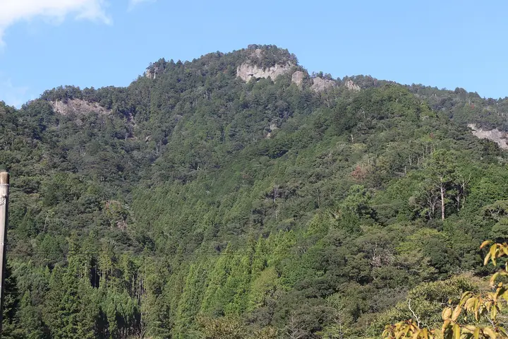
Horaijisan (695 m) is a sacred mountain in Shinshiro, Aichi Prefecture, representative of the Oku-Mikawa region. It is home to Horaiji temple—said to have been founded by the hermit Rishu in 703—and Horaisan Tosho-gu shrine, and is famed for its 1,425-step stone-paved approach and the 60-metre, 800-year-old "Kasasugi" cedar. The whole mountain is a nationally designated Place of Scenic Beauty and Natural Monument, and it is known as a haunt of the calling konohazuku owl. It appears on numerous lists, including the "New 100 Famous Mountains of Japan" and "100 Famous Low Mountains of Japan.". Formed of rhyolite from volcanic activity some 15 million years ago, it lies within Tenryu-Okumikawa Quasi-National Park.
Mt. Horaijisan at a glance
- Weather: The most settled day in the next 7 days is Wed, November 4: cloudy, gusts up to 5 m/s. Fri, Nov 6, Sat, Nov 7: strong wind (gusts up to 18 m/s).
- Route: The shortest is Mount Horaiji, Mount Ruri, and Takauchiba Circuit: about 2 h 47 min, 4.9 km, about 400 m of climbing.
Mt. Horaijisan weather (hourly, 14 days)
Sunrise today 06:12, sunset 16:55
| Tue, 11/3 | Wed, 11/4 | Thu, 11/5 | Fri, 11/6 | Sat, 11/7 | Sun, 11/8 | Mon, 11/9 | Tue, 11/10 | Wed, 11/11 | Thu, 11/12 | Fri, 11/13 | Sat, 11/14 | Sun, 11/15 | Mon, 11/16 | Tue, 11/17 | |||||||||||||||||||||||||||||||||||||||||||||||||||||||||||||||||||||||
|---|---|---|---|---|---|---|---|---|---|---|---|---|---|---|---|---|---|---|---|---|---|---|---|---|---|---|---|---|---|---|---|---|---|---|---|---|---|---|---|---|---|---|---|---|---|---|---|---|---|---|---|---|---|---|---|---|---|---|---|---|---|---|---|---|---|---|---|---|---|---|---|---|---|---|---|---|---|---|---|---|---|---|---|---|---|
| Japan time | 15 | 17 | 19 | 21 | 23 | 1 | 3 | 5 | 7 | 9 | 11 | 13 | 15 | 18 | 21 | 0 | 3 | 6 | 9 | 12 | 15 | 18 | 21 | 0 | 3 | 6 | 9 | 12 | 15 | 18 | 21 | 0 | 3 | 6 | 9 | 12 | 15 | 18 | 21 | 0 | 3 | 6 | 9 | 12 | 15 | 18 | 21 | 0 | 3 | 6 | 9 | 15 | 21 | 3 | 9 | 15 | 21 | 3 | 9 | 15 | 21 | 3 | 9 | 15 | 21 | 3 | 9 | 15 | 21 | 3 | 9 | 15 | 21 | 3 | 9 | 15 | 21 | 3 | 9 | 15 | 21 | 3 | 9 | 15 | |
  |   | |   | | | |   | |   | | |   |   | | | | | | |   | | | |   |   | |  | | |  | | | | | | | | | | | | | | | | | | | | | | | | | |   | | | | |  | | | | | | | | | | | | |   | | | |   | | | | | | ||
| Temperature | °C | 16° | 12° | 9° | 8° | 8° | 8° | 7° | 7° | 8° | 12° | 13° | 13° | 13° | 11° | 11° | 11° | 11° | 11° | 14° | 19° | 15° | 13° | 11° | 10° | 10° | 12° | 15° | 17° | 16° | 11° | 9° | 8° | 6° | 5° | 8° | 11° | 10° | 6° | 4° | 3° | 3° | 2° | 10° | 13° | 12° | 6° | 7° | 8° | 6° | 5° | 12° | 13° | 5° | 4° | 11° | 12° | 7° | 4° | 6° | 9° | 3° | 2° | 10° | 11° | 4° | 6° | 9° | 11° | 3° | 5° | 9° | 9° | 8° | 9° | 12° | 11° | 10° | 11° | 14° | 17° | 8° | 6° | 10° | 10° |
| Precipitation | mm | 0.5 | 0.2 | 0.4 | 0.5 | 2.3 | 8 | 4.9 | 1.8 | 1.1 | 0.2 | 3.5 | 21 | 23 | 5 | 0.5 | |||||||||||||||||||||||||||||||||||||||||||||||||||||||||||||||||||||
| New snow | cm | ||||||||||||||||||||||||||||||||||||||||||||||||||||||||||||||||||||||||||||||||||||
| Snow depth | cm | 0 | 0 | 0 | 0 | 0 | 0 | 0 | 0 | 0 | 0 | 0 | 0 | 0 | 0 | 0 | 0 | 0 | 0 | 0 | 0 | 0 | 0 | 0 | 0 | 0 | 0 | 0 | 0 | 0 | 0 | 0 | 0 | 0 | 0 | 0 | 0 | 0 | 0 | 0 | 0 | 0 | 0 | 0 | 0 | 0 | 0 | 0 | 0 | 0 | 0 | 0 | 0 | 0 | 0 | 0 | 0 | 0 | 0 | 0 | 0 | 0 | 0 | 0 | 0 | 0 | 0 | 0 | 0 | 0 | 0 | 0 | 0 | 0 | 0 | 0 | 0 | 0 | 0 | 0 | 0 | 0 | 0 | 0 | 0 |
| Wind | m/s | 1 | 1 | 1 | 2 | 2 | 2 | 2 | 2 | 2 | 2 | 1 | 1 | 1 | 3 | 1 | 2 | 2 | 3 | 2 | 1 | 2 | 0 | 1 | 2 | 2 | 3 | 6 | 7 | 7 | 7 | 6 | 7 | 7 | 6 | 6 | 8 | 7 | 5 | 5 | 5 | 5 | 4 | 2 | 2 | 2 | 2 | 1 | 1 | 2 | 2 | 2 | 5 | 1 | 2 | 0 | 3 | 4 | 7 | 6 | 7 | 4 | 3 | 1 | 2 | 3 | 4 | 4 | 6 | 3 | 3 | 1 | 1 | 2 | 2 | 2 | 2 | 1 | 2 | 4 | 6 | 5 | 3 | 3 | 3 |
| Wind gusts | m/s | 6 | 5 | 3 | 4 | 4 | 4 | 4 | 4 | 4 | 5 | 4 | 3 | 4 | 8 | 8 | 7 | 6 | 7 | 6 | 4 | 7 | 5 | 3 | 4 | 5 | 8 | 13 | 17 | 17 | 16 | 17 | 17 | 17 | 17 | 15 | 18 | 18 | 16 | 12 | 11 | 11 | 11 | 9 | 6 | 8 | 6 | 4 | 3 | 4 | 4 | 5 | 11 | 11 | 5 | 5 | 8 | 9 | 18 | 19 | 18 | 16 | 8 | 6 | 7 | 8 | 10 | 11 | 15 | 14 | 7 | 6 | 4 | 4 | 4 | 7 | 9 | 7 | 8 | 9 | 16 | 17 | 14 | 8 | 9 |
| Wind dir. | ↓ | ↓ | ↓ | ↓ | ↓ | ↓ | ↓ | ↓ | ↓ | ↓ | ↓ | ↓ | ↓ | ↓ | ↓ | ↓ | ↓ | ↓ | ↓ | ↓ | ↓ | ↓ | ↓ | ↓ | ↓ | ↓ | ↓ | ↓ | ↓ | ↓ | ↓ | ↓ | ↓ | ↓ | ↓ | ↓ | ↓ | ↓ | ↓ | ↓ | ↓ | ↓ | ↓ | ↓ | ↓ | ↓ | ↓ | ↓ | ↓ | ↓ | ↓ | ↓ | ↓ | ↓ | ↓ | ↓ | ↓ | ↓ | ↓ | ↓ | ↓ | ↓ | ↓ | ↓ | ↓ | ↓ | ↓ | ↓ | ↓ | ↓ | ↓ | ↓ | ↓ | ↓ | ↓ | ↓ | ↓ | ↓ | ↓ | ↓ | ↓ | ↓ | ↓ | ↓ | |
Mt. Horaijisan hiking routes
- Mount Horaiji, Mount Ruri, and Takauchiba Circuit 4.9 km · Ascent 400 m 鳳来山パークウェイ駐車場
- Mount Horaiji Summit Circuit via Omotesando 8.1 km · Ascent 640 m 千の灯火, 鳳来寺 (Bus stop)
Hiking times are estimates calculated from the terrain.
Huts, campsites and lodging near Mt. Horaijisan
Campsites
- オートキャンプ場
- Bキャンプ場
- 第一キャンプファイアー場
- Aキャンプ場
Lodging
- 雲龍荘
- 桔梗屋旅館
- 湯谷観光ホテル泉山閣
- 旅館ひさご
- 旅荘みつい
Lists that include Mt. Horaijisan
New Japan 100 Famous Mountains · 100 Low Mountains of Japan · Illustrated Collection of Japan's Famous Mountains · Tokai 100 Mountains · 130 Mountains of Aichi · Elevations of 1003 Mountains of Japan · 1000 Mountains of Japan
Mt. Horaijisan facts
- Elevation
- 695 m
- Location
- Shinshiro, Aichi
34.983997, 137.582758 - National Park
- 天竜奥三河国定公園
- Website
- www.city.shinshiro.lg.jp
- Trail Map
- www.city.shinshiro.lg.jp (PDF)
- Wikipedia
- ja.wikipedia.org