
Mt. Iwabitsu
岩櫃山
Higashiagatsuma, Gunma · Elevation 803 m
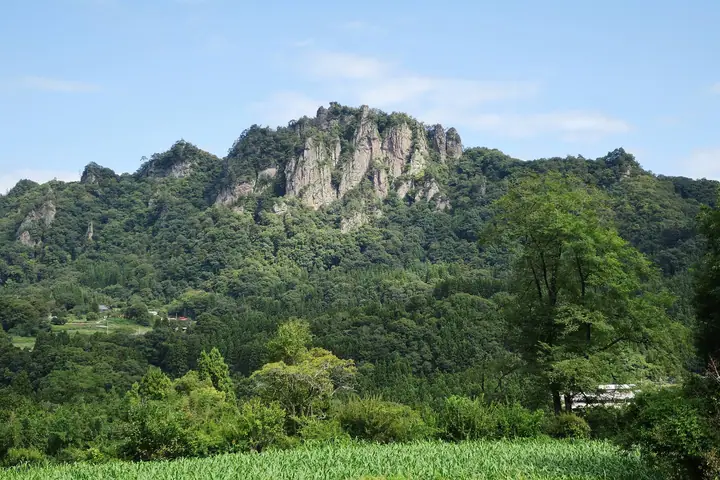
Mt. Iwabitsu (803 m) rises in Higashiagatsuma, Gunma, one of the chief scenic peaks of the Agatsuma Eight Views. A 200-metre cliff falls from its south face, the result of erosion of a six-million-year-old volcanic body. On the eastern slope stand the ruins of Iwabitsu Castle, an impregnable stronghold of the Sanada clan that featured in the 2016 NHK drama "Sanada-maru". Four trails (Sawa, Ridge, Mitsu-iwa, and Akaiwa) lead to the summit. Winter climbing (through late March) is discouraged due to snow and icing on chain sections.
Mt. Iwabitsu at a glance
- Weather: The most settled day in the next 7 days is Wed, November 4: clear, gusts up to 7 m/s.
- Route: The shortest is Mount Iwabitsu in Higashiagatsuma, Loop up the Mitsuiwa Trail and down the Akaiwa Trail: about 1 h 41 min, 2.8 km, about 350 m of climbing.
Mt. Iwabitsu weather (hourly, 14 days)
Sunrise today 06:09, sunset 16:48
| Tue, 11/3 | Wed, 11/4 | Thu, 11/5 | Fri, 11/6 | Sat, 11/7 | Sun, 11/8 | Mon, 11/9 | Tue, 11/10 | Wed, 11/11 | Thu, 11/12 | Fri, 11/13 | Sat, 11/14 | Sun, 11/15 | Mon, 11/16 | Tue, 11/17 | |||||||||||||||||||||||||||||||||||||||||||||||||||||||||||||||||||||||
|---|---|---|---|---|---|---|---|---|---|---|---|---|---|---|---|---|---|---|---|---|---|---|---|---|---|---|---|---|---|---|---|---|---|---|---|---|---|---|---|---|---|---|---|---|---|---|---|---|---|---|---|---|---|---|---|---|---|---|---|---|---|---|---|---|---|---|---|---|---|---|---|---|---|---|---|---|---|---|---|---|---|---|---|---|---|
| Japan time | 15 | 17 | 19 | 21 | 23 | 1 | 3 | 5 | 7 | 9 | 11 | 13 | 15 | 18 | 21 | 0 | 3 | 6 | 9 | 12 | 15 | 18 | 21 | 0 | 3 | 6 | 9 | 12 | 15 | 18 | 21 | 0 | 3 | 6 | 9 | 12 | 15 | 18 | 21 | 0 | 3 | 6 | 9 | 12 | 15 | 18 | 21 | 0 | 3 | 6 | 9 | 15 | 21 | 3 | 9 | 15 | 21 | 3 | 9 | 15 | 21 | 3 | 9 | 15 | 21 | 3 | 9 | 15 | 21 | 3 | 9 | 15 | 21 | 3 | 9 | 15 | 21 | 3 | 9 | 15 | 21 | 3 | 9 | 15 | |
  |   | | | | | | |  | | | | |   |   | | | |   |   | | | | | | | | | |  | | | |   | | | | | | | | | | | | | | | | | |   | | | | | | |   | | | | |   | | | | | | | | |  | | | | |   | | |   | | | | ||
| Temperature | °C | 12° | 8° | 5° | 3° | 2° | 1° | 2° | 2° | 3° | 11° | 12° | 13° | 11° | 8° | 7° | 7° | 7° | 8° | 11° | 13° | 14° | 10° | 11° | 10° | 8° | 7° | 15° | 20° | 18° | 10° | 9° | 8° | 7° | 6° | 10° | 12° | 10° | 5° | 4° | 4° | 4° | 4° | 8° | 11° | 9° | 6° | 4° | 4° | 5° | 5° | 8° | 9° | 7° | 6° | 6° | 7° | 5° | 4° | 5° | 7° | 4° | 1° | 7° | 9° | 2° | 1° | 8° | 8° | 1° | -1° | 6° | 8° | 1° | 0° | 7° | 11° | 6° | 6° | 12° | 13° | 6° | 2° | 6° | 8° |
| Precipitation | mm | 0.2 | 0.9 | 10 | 5 | 1.9 | 0.6 | 0.3 | 0.8 | 1.4 | 0.3 | 0.2 | 1.3 | 1.5 | 1.7 | 0.3 | 4.7 | 7 | 0.2 | ||||||||||||||||||||||||||||||||||||||||||||||||||||||||||||||||||
| New snow | cm | 0.1 | <.1 | ||||||||||||||||||||||||||||||||||||||||||||||||||||||||||||||||||||||||||||||||||
| Snow depth | cm | 0 | 0 | 0 | 0 | 0 | 0 | 0 | 0 | 0 | 0 | 0 | 0 | 0 | 0 | 0 | 0 | 0 | 0 | 0 | 0 | 0 | 0 | 0 | 0 | 0 | 0 | 0 | 0 | 0 | 0 | 0 | 0 | 0 | 0 | 0 | 0 | 0 | 0 | 0 | 0 | 0 | 0 | 0 | 0 | 0 | 0 | 0 | 0 | 0 | 0 | 0 | 0 | 0 | 0 | 0 | 0 | 0 | 0 | <1 | 0 | 0 | 0 | 0 | 0 | 0 | 0 | 0 | 0 | 0 | 0 | 0 | 0 | 0 | 0 | 0 | 0 | 0 | 0 | 0 | 0 | 0 | 0 | 0 | 0 |
| Wind | m/s | 3 | 1 | 1 | 1 | 1 | 0 | 0 | 0 | 1 | 1 | 2 | 2 | 2 | 1 | 1 | 1 | 1 | 1 | 1 | 0 | 0 | 0 | 1 | 0 | 1 | 1 | 1 | 2 | 2 | 1 | 1 | 2 | 2 | 1 | 1 | 3 | 2 | 1 | 1 | 2 | 2 | 1 | 1 | 2 | 3 | 1 | 1 | 0 | 1 | 1 | 2 | 2 | 1 | 1 | 2 | 2 | 1 | 1 | 3 | 1 | 1 | 0 | 1 | 3 | 0 | 0 | 1 | 1 | 1 | 1 | 1 | 2 | 0 | 0 | 0 | 2 | 1 | 1 | 1 | 3 | 1 | 1 | 1 | 2 |
| Wind gusts | m/s | 8 | 8 | 2 | 3 | 3 | 3 | 2 | 2 | 2 | 4 | 6 | 7 | 7 | 7 | 4 | 3 | 3 | 3 | 4 | 4 | 3 | 3 | 3 | 2 | 2 | 3 | 4 | 6 | 7 | 7 | 3 | 5 | 5 | 5 | 6 | 8 | 9 | 6 | 4 | 4 | 5 | 4 | 5 | 6 | 9 | 8 | 3 | 2 | 2 | 2 | 5 | 7 | 6 | 4 | 5 | 7 | 6 | 5 | 15 | 10 | 6 | 3 | 5 | 9 | 7 | 3 | 5 | 7 | 5 | 3 | 5 | 7 | 5 | 1 | 3 | 6 | 4 | 4 | 3 | 10 | 10 | 4 | 5 | 7 |
| Wind dir. | ↓ | ↓ | ↓ | ↓ | ↓ | ↓ | ↓ | ↓ | ↓ | ↓ | ↓ | ↓ | ↓ | ↓ | ↓ | ↓ | ↓ | ↓ | ↓ | ↓ | ↓ | ↓ | ↓ | ↓ | ↓ | ↓ | ↓ | ↓ | ↓ | ↓ | ↓ | ↓ | ↓ | ↓ | ↓ | ↓ | ↓ | ↓ | ↓ | ↓ | ↓ | ↓ | ↓ | ↓ | ↓ | ↓ | ↓ | ↓ | ↓ | ↓ | ↓ | ↓ | ↓ | ↓ | ↓ | ↓ | ↓ | ↓ | ↓ | ↓ | ↓ | ↓ | ↓ | ↓ | ↓ | ↓ | ↓ | ↓ | ↓ | ↓ | ↓ | ↓ | ↓ | ↓ | ↓ | ↓ | ↓ | ↓ | ↓ | ↓ | ↓ | ↓ | ↓ | ↓ | |
Mt. Iwabitsu hiking routes
- Mount Iwabitsu in Higashiagatsuma, Loop up the Mitsuiwa Trail and down the Akaiwa Trail 2.8 km · Ascent 351 m 岩櫃山登山道
- Mount Iwabitsu and Iwabitsu Castle Ruins Loop from Hirasawa Trailhead 3.0 km · Ascent 327 m 平沢登山口駐車場
Hiking times are estimates calculated from the terrain.
Huts, campsites and lodging near Mt. Iwabitsu
Lodging
- フォレストリゾートコニファーいわびつ
Lists that include Mt. Iwabitsu
Mt. Iwabitsu facts
- Elevation
- 803 m
- Location
- Higashiagatsuma, Gunma
36.556990, 138.796227 - Trail Map
- www.town.higashiagatsuma.gunma.jp (PDF)
- Wikipedia
- ja.wikipedia.org