
Mt. Hangetsu
半月山
Nikkō-shi, Tochigi · Elevation 1,753 m
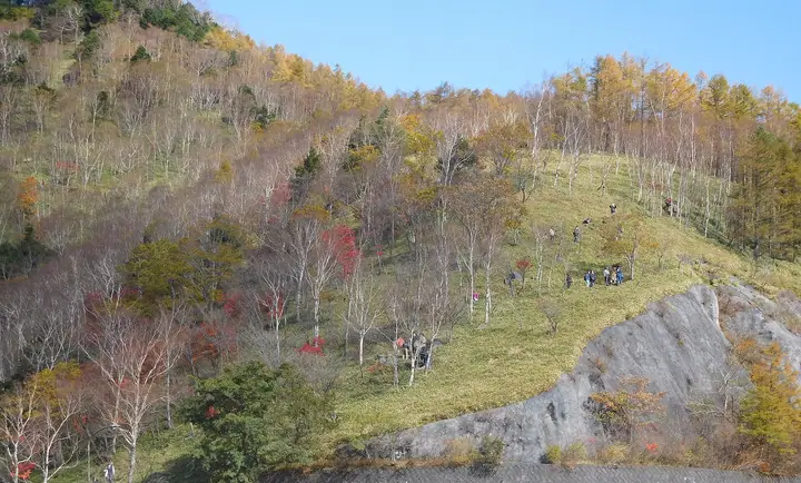
A 1,753 m peak straddling the Chūgūshi and Ashio districts of Nikko City, Tochigi, regarded as one of the headline view points of Oku-Nikkō inside Nikkō National Park. From the upper car park at the end of the Chūzenji-ko Skyline, a 30-minute climb leads to the summit observation deck, from which Mt. Nantai rises above Lake Chūzenji with the Hatchō-deshima peninsula and Kōzu Island below, and views run out to Senjōgahara and Mt. Shirane in the distance. Late October colour and early summer Tōgoku-mitsuba azaleas are the peak seasons; the skyline road is shut from late November to mid April each winter.
Mt. Hangetsu at a glance
- Weather: The most settled day in the next 7 days is Wed, November 4: clear, gusts up to 8 m/s. Sat, Nov 7: strong wind (gusts up to 20 m/s).
Mt. Hangetsu weather (hourly, 14 days)
Sunrise today 06:07, sunset 16:45
| Tue, 11/3 | Wed, 11/4 | Thu, 11/5 | Fri, 11/6 | Sat, 11/7 | Sun, 11/8 | Mon, 11/9 | Tue, 11/10 | Wed, 11/11 | Thu, 11/12 | Fri, 11/13 | Sat, 11/14 | Sun, 11/15 | Mon, 11/16 | Tue, 11/17 | |||||||||||||||||||||||||||||||||||||||||||||||||||||||||||||||||||||||
|---|---|---|---|---|---|---|---|---|---|---|---|---|---|---|---|---|---|---|---|---|---|---|---|---|---|---|---|---|---|---|---|---|---|---|---|---|---|---|---|---|---|---|---|---|---|---|---|---|---|---|---|---|---|---|---|---|---|---|---|---|---|---|---|---|---|---|---|---|---|---|---|---|---|---|---|---|---|---|---|---|---|---|---|---|---|
| Japan time | 15 | 17 | 19 | 21 | 23 | 1 | 3 | 5 | 7 | 9 | 11 | 13 | 15 | 18 | 21 | 0 | 3 | 6 | 9 | 12 | 15 | 18 | 21 | 0 | 3 | 6 | 9 | 12 | 15 | 18 | 21 | 0 | 3 | 6 | 9 | 12 | 15 | 18 | 21 | 0 | 3 | 6 | 9 | 12 | 15 | 18 | 21 | 0 | 3 | 6 | 9 | 15 | 21 | 3 | 9 | 15 | 21 | 3 | 9 | 15 | 21 | 3 | 9 | 15 | 21 | 3 | 9 | 15 | 21 | 3 | 9 | 15 | 21 | 3 | 9 | 15 | 21 | 3 | 9 | 15 | 21 | 3 | 9 | 15 | |
 |  |   | | | | | | | |   |   |   |   |   | | | |   | |   | |   | |  | | | | | | | | |   |   | | | | |   | | | | | | | | | | | | | | | | | | | | | | | | |   | |   | | |  | | | | | | | | | | |   | | | | ||
| Temperature | °C | 6° | 2° | 0° | 1° | 1° | 0° | 1° | 1° | 2° | 5° | 7° | 8° | 6° | 3° | 3° | 3° | 4° | 5° | 8° | 10° | 10° | 7° | 5° | 6° | 6° | 5° | 9° | 11° | 9° | 5° | 3° | 1° | 0° | -1° | 0° | 0° | -1° | -3° | -3° | -4° | -4° | -4° | 1° | 4° | 3° | -1° | -1° | 0° | -1° | 0° | 2° | 3° | 0° | -1° | 1° | 2° | 0° | -1° | -1° | -1° | -2° | -3° | 1° | 3° | -1° | -1° | 2° | -1° | -3° | -4° | 3° | 4° | -2° | 0° | 6° | 7° | 4° | 5° | 11° | 5° | -1° | -3° | 2° | 3° |
| Precipitation | mm | 0.5 | 1.1 | 9 | 9 | 1.9 | 0.2 | 0.1 | 0.2 | 0.2 | 0.3 | 0.2 | 0.5 | 0.3 | 0.2 | 0.4 | 1.9 | 1.8 | 0.2 | 0.1 | 0.5 | 4.9 | 9 | 0.3 | 0.7 | ||||||||||||||||||||||||||||||||||||||||||||||||||||||||||||
| New snow | cm | <.1 | <.1 | 0.2 | 0.3 | 0.2 | <.1 | <.1 | <.1 | <.1 | 0.2 | 1.8 | 1.7 | 0.1 | 0.3 | 0.2 | |||||||||||||||||||||||||||||||||||||||||||||||||||||||||||||||||||||
| Snow depth | cm | 0 | 0 | 0 | 0 | 0 | 0 | 0 | 0 | 0 | 0 | 0 | 0 | 0 | 0 | 0 | 0 | 0 | 0 | 0 | 0 | 0 | 0 | 0 | 0 | 0 | 0 | 0 | 0 | 0 | 0 | 0 | 0 | 0 | 0 | 0 | 0 | <1 | <1 | <1 | <1 | <1 | <1 | <1 | <1 | <1 | <1 | <1 | <1 | <1 | <1 | <1 | 0 | 0 | 0 | 0 | 0 | 0 | 0 | 1 | 2 | 2 | 2 | 1 | 1 | <1 | <1 | 1 | 1 | 1 | 1 | <1 | <1 | <1 | <1 | <1 | <1 | <1 | 0 | 0 | 0 | 0 | 0 | 0 | 0 |
| Wind | m/s | 0 | 0 | 1 | 1 | 1 | 1 | 0 | 0 | 0 | 1 | 2 | 2 | 2 | 1 | 2 | 1 | 1 | 1 | 1 | 0 | 1 | 1 | 1 | 1 | 1 | 1 | 3 | 3 | 1 | 2 | 3 | 4 | 4 | 4 | 4 | 6 | 6 | 4 | 4 | 4 | 3 | 2 | 2 | 1 | 1 | 1 | 1 | 1 | 1 | 1 | 1 | 1 | 0 | 0 | 1 | 2 | 2 | 2 | 6 | 6 | 1 | 2 | 1 | 1 | 1 | 1 | 3 | 3 | 1 | 2 | 1 | 1 | 1 | 1 | 1 | 2 | 1 | 3 | 1 | 5 | 4 | 2 | 1 | 2 |
| Wind gusts | m/s | 6 | 5 | 5 | 5 | 5 | 5 | 4 | 4 | 3 | 5 | 6 | 8 | 8 | 7 | 7 | 7 | 6 | 6 | 6 | 5 | 6 | 6 | 5 | 5 | 5 | 5 | 11 | 11 | 9 | 7 | 10 | 13 | 15 | 17 | 17 | 20 | 20 | 19 | 15 | 15 | 14 | 13 | 10 | 9 | 8 | 6 | 7 | 6 | 7 | 7 | 7 | 7 | 4 | 4 | 5 | 8 | 9 | 9 | 21 | 24 | 20 | 7 | 6 | 7 | 6 | 6 | 10 | 12 | 12 | 9 | 7 | 6 | 5 | 4 | 6 | 9 | 7 | 11 | 11 | 18 | 16 | 14 | 6 | 6 |
| Wind dir. | ↓ | ↓ | ↓ | ↓ | ↓ | ↓ | ↓ | ↓ | ↓ | ↓ | ↓ | ↓ | ↓ | ↓ | ↓ | ↓ | ↓ | ↓ | ↓ | ↓ | ↓ | ↓ | ↓ | ↓ | ↓ | ↓ | ↓ | ↓ | ↓ | ↓ | ↓ | ↓ | ↓ | ↓ | ↓ | ↓ | ↓ | ↓ | ↓ | ↓ | ↓ | ↓ | ↓ | ↓ | ↓ | ↓ | ↓ | ↓ | ↓ | ↓ | ↓ | ↓ | ↓ | ↓ | ↓ | ↓ | ↓ | ↓ | ↓ | ↓ | ↓ | ↓ | ↓ | ↓ | ↓ | ↓ | ↓ | ↓ | ↓ | ↓ | ↓ | ↓ | ↓ | ↓ | ↓ | ↓ | ↓ | ↓ | ↓ | ↓ | ↓ | ↓ | ↓ | ↓ | |
Huts, campsites and lodging near Mt. Hangetsu
Campsites
- Fishing & Glamping
Lodging
- Nikko Beans Hotel
- 民宿 おかじん
- Hoshino Resorts Hotel
- Kojo-en
- Hatago Nagomi, Nikko
Lists that include Mt. Hangetsu
Mt. Hangetsu facts
- Elevation
- 1,753 m
- Location
- Nikkō-shi, Tochigi
36.710747, 139.475845 - National Park
- 日光国立公園
- Website
- www.nikko-kankou.org
- Trail Map
- www.nikko-kankou.org (PDF)
- Wikipedia
- ja.wikipedia.org