
Mount Tanigawa
谷川岳 オキノ耳
Minakami, Gunma · Elevation 1,977 m
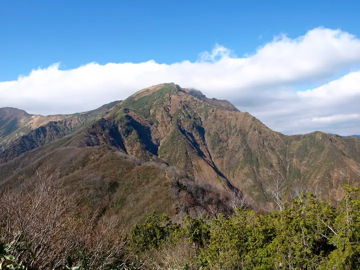
Mount Tanigawa (Oki-no-Mimi 1,977 m / Toma-no-Mimi 1,963 m) straddles the border of Minakami Town in Gunma and Yuzawa Town in Niigata on the Jōetsu watershed. Its east face, Ichinokurasawa, is one of Japan's three great rock walls and has a storied climbing history. The peak lies in the heart of Jōshin'etsu-Kōgen National Park and the Minakami UNESCO Eco Park; the Tanigawadake Joch ropeway (formerly Tanigawadake Ropeway) carries hikers quickly to the Tenjindaira ridge. It appears in the 100 Famous Japanese Mountains and many other major lists, with a 山開き (mountain-opening) Shinto rite held annually in early July.
Mount Tanigawa at a glance
- Weather: The most settled day in the next 7 days is Wed, November 4: clear, gusts up to 10 m/s. Sat, Nov 7, Sun, Nov 8: strong wind (gusts up to 19 m/s).
- Route: The shortest is Mount Tanigawa Nishiguro Ridge Ascent and Tenjin Ridge Descent: about 5 h 57 min, 8.1 km, about 1,320 m of climbing.
Mount Tanigawa weather (hourly, 14 days)
Sunrise today 06:09, sunset 16:47
| Tue, 11/3 | Wed, 11/4 | Thu, 11/5 | Fri, 11/6 | Sat, 11/7 | Sun, 11/8 | Mon, 11/9 | Tue, 11/10 | Wed, 11/11 | Thu, 11/12 | Fri, 11/13 | Sat, 11/14 | Sun, 11/15 | Mon, 11/16 | Tue, 11/17 | |||||||||||||||||||||||||||||||||||||||||||||||||||||||||||||||||||||||
|---|---|---|---|---|---|---|---|---|---|---|---|---|---|---|---|---|---|---|---|---|---|---|---|---|---|---|---|---|---|---|---|---|---|---|---|---|---|---|---|---|---|---|---|---|---|---|---|---|---|---|---|---|---|---|---|---|---|---|---|---|---|---|---|---|---|---|---|---|---|---|---|---|---|---|---|---|---|---|---|---|---|---|---|---|---|
| Japan time | 15 | 17 | 19 | 21 | 23 | 1 | 3 | 5 | 7 | 9 | 11 | 13 | 15 | 18 | 21 | 0 | 3 | 6 | 9 | 12 | 15 | 18 | 21 | 0 | 3 | 6 | 9 | 12 | 15 | 18 | 21 | 0 | 3 | 6 | 9 | 12 | 15 | 18 | 21 | 0 | 3 | 6 | 9 | 12 | 15 | 18 | 21 | 0 | 3 | 6 | 9 | 15 | 21 | 3 | 9 | 15 | 21 | 3 | 9 | 15 | 21 | 3 | 9 | 15 | 21 | 3 | 9 | 15 | 21 | 3 | 9 | 15 | 21 | 3 | 9 | 15 | 21 | 3 | 9 | 15 | 21 | 3 | 9 | 15 | |
  |   | | | | | | |  | | | |   |   |   | | | | |   | |   | | | | | | | | | | | |   |   | | | | |   | | |   | | | | | | | | | | | |   | | | | | | | | | | | | | | | | | |  | | |   | |   | | | | | | | ||
| Temperature | °C | 2° | 0° | -2° | -3° | -3° | -3° | -3° | -3° | -1° | 4° | 6° | 7° | 5° | 1° | 0° | 0° | 1° | 2° | 4° | 9° | 9° | 5° | 4° | 4° | 3° | 4° | 6° | 6° | 6° | 3° | 1° | 0° | -2° | -3° | -3° | -3° | -3° | -4° | -4° | -5° | -5° | -5° | -3° | -2° | -2° | -4° | -5° | -4° | -3° | -4° | 0° | 0° | -3° | -3° | 0° | 0° | -2° | -5° | -4° | -4° | -4° | -4° | -2° | -1° | -5° | -3° | -4° | -4° | -5° | -6° | 0° | 3° | -5° | -5° | 2° | 3° | 0° | 1° | 4° | 1° | -4° | -6° | -3° | 0° |
| Precipitation | mm | 0.1 | 0.2 | 0.3 | 10 | 7 | 0.9 | 1.3 | 0.2 | 0.3 | 1.0 | 0.4 | 0.4 | 1.3 | 2.1 | 1.0 | 0.6 | 1.8 | 1.8 | 1.6 | 1.1 | 0.8 | 0.7 | 0.2 | 0.2 | 0.1 | 0.2 | 0.4 | 0.3 | 0.1 | 0.2 | 0.6 | 0.2 | 0.2 | 5 | 3.5 | 9 | 4.0 | 1.6 | 9 | 3.8 | 1.2 | 0.2 | 4.2 | 5 | 0.2 | 7 | 12 | 3.0 | ||||||||||||||||||||||||||||||||||||
| New snow | cm | <.1 | 1.0 | 1.2 | 1.2 | 0.9 | 0.6 | 0.6 | 0.2 | 0.2 | <.1 | <.1 | <.1 | <.1 | <.1 | 4.3 | 3.3 | 6.2 | 1.4 | 0.6 | 6.2 | 3.2 | 1.0 | <.1 | 2.0 | 2.1 | |||||||||||||||||||||||||||||||||||||||||||||||||||||||||||
| Snow depth | cm | 0 | 0 | 0 | 0 | 0 | 0 | 0 | 0 | 0 | 0 | 0 | 0 | 0 | 0 | 0 | 0 | 0 | 0 | 0 | 0 | 0 | 0 | 0 | 0 | 0 | 0 | 0 | 0 | 0 | 0 | 0 | 0 | 0 | 0 | <1 | 1 | 1 | 1 | 2 | 2 | 2 | 2 | 2 | 2 | 2 | 1 | 1 | 1 | 1 | 1 | 1 | <1 | <1 | <1 | <1 | <1 | 0 | 3 | 5 | 6 | 7 | 6 | 5 | 3 | 3 | 3 | 6 | 7 | 7 | 7 | 7 | 5 | 5 | 5 | 5 | 3 | 2 | 2 | 1 | <1 | 1 | 2 | 2 | 1 |
| Wind | m/s | 4 | 3 | 2 | 2 | 2 | 2 | 2 | 2 | 2 | 1 | 1 | 3 | 3 | 4 | 3 | 4 | 2 | 1 | 1 | 1 | 1 | 1 | 0 | 1 | 2 | 2 | 3 | 4 | 3 | 4 | 4 | 5 | 5 | 5 | 5 | 6 | 5 | 6 | 5 | 4 | 5 | 4 | 4 | 5 | 4 | 2 | 2 | 2 | 2 | 2 | 1 | 3 | 2 | 1 | 3 | 3 | 2 | 3 | 8 | 8 | 4 | 2 | 2 | 2 | 1 | 3 | 3 | 6 | 4 | 2 | 1 | 1 | 1 | 0 | 1 | 1 | 1 | 1 | 2 | 7 | 7 | 4 | 2 | 2 |
| Wind gusts | m/s | 14 | 12 | 8 | 6 | 5 | 5 | 6 | 5 | 5 | 5 | 6 | 8 | 10 | 12 | 12 | 13 | 12 | 9 | 7 | 5 | 5 | 4 | 4 | 3 | 5 | 8 | 10 | 11 | 11 | 10 | 13 | 16 | 17 | 18 | 17 | 19 | 19 | 19 | 18 | 16 | 17 | 17 | 14 | 15 | 16 | 13 | 6 | 6 | 5 | 6 | 5 | 9 | 9 | 6 | 8 | 11 | 10 | 10 | 28 | 28 | 25 | 12 | 8 | 9 | 8 | 8 | 10 | 20 | 20 | 13 | 8 | 5 | 5 | 4 | 5 | 6 | 7 | 8 | 8 | 20 | 22 | 21 | 11 | 7 |
| Wind dir. | ↓ | ↓ | ↓ | ↓ | ↓ | ↓ | ↓ | ↓ | ↓ | ↓ | ↓ | ↓ | ↓ | ↓ | ↓ | ↓ | ↓ | ↓ | ↓ | ↓ | ↓ | ↓ | ↓ | ↓ | ↓ | ↓ | ↓ | ↓ | ↓ | ↓ | ↓ | ↓ | ↓ | ↓ | ↓ | ↓ | ↓ | ↓ | ↓ | ↓ | ↓ | ↓ | ↓ | ↓ | ↓ | ↓ | ↓ | ↓ | ↓ | ↓ | ↓ | ↓ | ↓ | ↓ | ↓ | ↓ | ↓ | ↓ | ↓ | ↓ | ↓ | ↓ | ↓ | ↓ | ↓ | ↓ | ↓ | ↓ | ↓ | ↓ | ↓ | ↓ | ↓ | ↓ | ↓ | ↓ | ↓ | ↓ | ↓ | ↓ | ↓ | ↓ | ↓ | ↓ | |
Mount Tanigawa hiking routes
- Mount Tanigawa Nishiguro Ridge Ascent and Tenjin Ridge Descent 8.1 km · Ascent 1,324 m Tanigawadake Yoch (Bus stop), 土合口 (Aerialway station) (parking) → 天神平 (Aerialway station)
- Joetsu Border Steep Nishiguro Ridge over the Twin Summits of Tanigawa and down the Shigekura Trail to Tsuchitaru 14.6 km · Ascent 1,565 m Doaibashi (Bus stop) (parking) → 土樽駅 (Station), Tsuchitaru (Station)
Hiking times are estimates calculated from the terrain.
Huts, campsites and lodging near Mount Tanigawa
Mountain huts
- Tanigawadake Kata no Koya 2026: open June 1–November 3 · reservation required
- 一ノ倉岳避難小屋 unstaffed · sleeps 2
- 熊穴沢避難小屋 unstaffed
- オジカ沢ノ頭避難小屋 unstaffed · sleeps 4
- 茂倉岳避難小屋 unstaffed · sleeps 20
Lodging
- Tenjin Lodge
Lists that include Mount Tanigawa
100 Famous Japanese Mountains · Japan 200 Famous Mountains · Japan's 300 Famous Mountains · New Japan 100 Famous Mountains · 100 Famous Hot Spring Mountains · 100 Fujis of Japan · Kanto 100 Famous Mountains · Koshinetsu 100 Famous Mountains · Gunma 100 Famous Mountains · Niigata 100 Famous Mountains · Elevations of 1003 Mountains of Japan · 1000 Mountains of Japan
Mount Tanigawa facts
- Also known as
- 谷川富士 · オキノ耳 · トマノ耳
- Elevation
- 1,977 m
- Location
- Minakami, Gunma
36.837107, 138.930182 - National Park
- 上信越高原国立公園
- Website
- tanigawa-ic.com
- Trail Map
- www.enjoy-minakami.jp (PDF)
- Access Information
- tanigawa-ic.com
- Wikipedia
- ja.wikipedia.org