
Mount Orofure
オロフレ山
Shiraoi, Hokkaido · Elevation 1,231 m
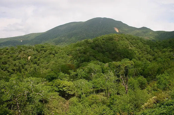
Mount Orofure is a 1,230.8 m volcano on the border between Shiraoi Town and Sōbetsu Town in Hokkaido, set within Shikotsu-Tōya National Park. Its name derives from the Ainu words "u-oro-fure-pet," meaning "the river whose waters are red." From the Orofure Pass trailhead at about 930 m, the route climbs past Rakan Rock to the summit in roughly 1 hour 30 minutes, with around 300 m of elevation gain — a family-friendly outing. Iwahige, chinguruma, and miyama-odamaki line the path, and on clear days the summit looks out to Mount Yōtei, Lake Tōya, Funka Bay, and the Pacific Ocean. The peak features in Shin Hana no Hyakumeizan and Hokkaidō Hyakumeizan.
Mount Orofure at a glance
- Weather: The most settled day in the next 7 days is Thu, November 5: clear, gusts up to 7 m/s. Wed, Nov 4, Fri, Nov 6, Sat, Nov 7, Sun, Nov 8: strong wind (gusts up to 22 m/s).
- Route: The shortest is Mount Orofure Return from the Former Orofure Pass Lookout: about 3 h 15 min, 5.2 km, about 450 m of climbing.
Mount Orofure weather (hourly, 14 days)
Sunrise today 06:11, sunset 16:28
| Tue, 11/3 | Wed, 11/4 | Thu, 11/5 | Fri, 11/6 | Sat, 11/7 | Sun, 11/8 | Mon, 11/9 | Tue, 11/10 | Wed, 11/11 | Thu, 11/12 | Fri, 11/13 | Sat, 11/14 | Sun, 11/15 | Mon, 11/16 | Tue, 11/17 | |||||||||||||||||||||||||||||||||||||||||||||||||||||||||||||||||||||||
|---|---|---|---|---|---|---|---|---|---|---|---|---|---|---|---|---|---|---|---|---|---|---|---|---|---|---|---|---|---|---|---|---|---|---|---|---|---|---|---|---|---|---|---|---|---|---|---|---|---|---|---|---|---|---|---|---|---|---|---|---|---|---|---|---|---|---|---|---|---|---|---|---|---|---|---|---|---|---|---|---|---|---|---|---|---|
| Japan time | 15 | 17 | 19 | 21 | 23 | 1 | 3 | 5 | 7 | 9 | 11 | 13 | 15 | 18 | 21 | 0 | 3 | 6 | 9 | 12 | 15 | 18 | 21 | 0 | 3 | 6 | 9 | 12 | 15 | 18 | 21 | 0 | 3 | 6 | 9 | 12 | 15 | 18 | 21 | 0 | 3 | 6 | 9 | 12 | 15 | 18 | 21 | 0 | 3 | 6 | 9 | 15 | 21 | 3 | 9 | 15 | 21 | 3 | 9 | 15 | 21 | 3 | 9 | 15 | 21 | 3 | 9 | 15 | 21 | 3 | 9 | 15 | 21 | 3 | 9 | 15 | 21 | 3 | 9 | 15 | 21 | 3 | 9 | 15 | |
 |   | | |   |   |   |  |   | | | | |  | | | | |   | | | |   | | | |   |   | |   |   |   | | |   |   | |   | | | | | | | | | |   | | |   | | | | | | | | | | | | |   | | | | | | | | | | | | | | | |   | |  | | | ||
| Temperature | °C | -1° | -3° | -3° | -5° | -4° | -3° | -3° | -2° | -2° | -1° | 1° | 2° | 1° | -4° | -5° | -4° | -3° | -2° | 4° | 7° | 7° | 2° | 3° | 4° | 4° | 4° | 6° | 8° | 4° | 0° | -3° | -5° | -6° | -7° | -5° | -5° | -5° | -6° | -6° | -7° | -7° | -7° | -5° | -4° | -5° | -6° | -6° | -6° | -6° | -7° | -5° | -5° | -8° | -8° | -5° | -4° | -6° | -6° | -4° | -1° | -9° | -8° | -2° | -3° | -7° | -8° | -7° | -6° | -7° | -10° | -3° | -1° | -6° | -2° | 1° | 1° | 0° | 0° | -2° | -3° | -7° | -7° | -3° | -3° |
| Precipitation | mm | 4.8 | 1.5 | 0.3 | 4.7 | 4.8 | 2.3 | 0.3 | 0.1 | 1.1 | 0.2 | 0.2 | 0.6 | 0.5 | 0.5 | 0.5 | 0.7 | 0.5 | 0.6 | 0.7 | 0.5 | 0.4 | 0.3 | 0.3 | 0.3 | 0.3 | 2.3 | 1.2 | 0.3 | 0.7 | 0.6 | 1.2 | 1.4 | 3.7 | 1.4 | 1.1 | |||||||||||||||||||||||||||||||||||||||||||||||||
| New snow | cm | 3.9 | 1.2 | 0.6 | 0.5 | 0.5 | 0.5 | 0.7 | 0.5 | 0.6 | 0.7 | 0.5 | 0.4 | 0.3 | 0.3 | 0.3 | 0.3 | <.1 | 2.3 | 1.2 | 0.2 | 0.5 | <.1 | 0.4 | |||||||||||||||||||||||||||||||||||||||||||||||||||||||||||||
| Snow depth | cm | 0 | 0 | 0 | 0 | 0 | 2 | 3 | 3 | 3 | 2 | 2 | 2 | 1 | 1 | 1 | 1 | 1 | 1 | 1 | <1 | <1 | 0 | 0 | 0 | 0 | 0 | 0 | 0 | 0 | 0 | 0 | 0 | <1 | <1 | <1 | 2 | 2 | 2 | 2 | 3 | 3 | 3 | 3 | 3 | 3 | 3 | 3 | 3 | 3 | 3 | 3 | 3 | 3 | 3 | 3 | 2 | 2 | 4 | 5 | 5 | 4 | 4 | 4 | 5 | 4 | 4 | 4 | 4 | 4 | 4 | 4 | 4 | 4 | 4 | 3 | 2 | 1 | 1 | <1 | 1 | <1 | <1 | <1 | <1 |
| Wind | m/s | 5 | 3 | 3 | 1 | 3 | 3 | 3 | 6 | 5 | 5 | 3 | 2 | 2 | 0 | 0 | 0 | 1 | 1 | 1 | 2 | 1 | 1 | 1 | 1 | 0 | 0 | 3 | 5 | 6 | 7 | 7 | 7 | 6 | 5 | 7 | 8 | 8 | 8 | 7 | 7 | 7 | 7 | 8 | 8 | 7 | 7 | 5 | 4 | 3 | 3 | 4 | 4 | 2 | 1 | 1 | 1 | 2 | 2 | 1 | 1 | 1 | 1 | 3 | 4 | 2 | 1 | 5 | 4 | 2 | 1 | 1 | 1 | 1 | 1 | 2 | 2 | 1 | 0 | 2 | 5 | 4 | 3 | 2 | 3 |
| Wind gusts | m/s | 15 | 14 | 10 | 10 | 10 | 15 | 12 | 16 | 16 | 15 | 14 | 9 | 7 | 6 | 4 | 4 | 5 | 4 | 5 | 7 | 6 | 4 | 5 | 6 | 6 | 4 | 10 | 13 | 17 | 19 | 21 | 20 | 20 | 17 | 19 | 21 | 22 | 23 | 22 | 21 | 21 | 21 | 22 | 22 | 22 | 19 | 18 | 14 | 11 | 10 | 13 | 12 | 11 | 7 | 5 | 7 | 8 | 9 | 7 | 6 | 6 | 5 | 9 | 14 | 12 | 8 | 14 | 14 | 11 | 7 | 5 | 7 | 6 | 7 | 8 | 9 | 7 | 5 | 7 | 13 | 15 | 12 | 9 | 10 |
| Wind dir. | ↓ | ↓ | ↓ | ↓ | ↓ | ↓ | ↓ | ↓ | ↓ | ↓ | ↓ | ↓ | ↓ | ↓ | ↓ | ↓ | ↓ | ↓ | ↓ | ↓ | ↓ | ↓ | ↓ | ↓ | ↓ | ↓ | ↓ | ↓ | ↓ | ↓ | ↓ | ↓ | ↓ | ↓ | ↓ | ↓ | ↓ | ↓ | ↓ | ↓ | ↓ | ↓ | ↓ | ↓ | ↓ | ↓ | ↓ | ↓ | ↓ | ↓ | ↓ | ↓ | ↓ | ↓ | ↓ | ↓ | ↓ | ↓ | ↓ | ↓ | ↓ | ↓ | ↓ | ↓ | ↓ | ↓ | ↓ | ↓ | ↓ | ↓ | ↓ | ↓ | ↓ | ↓ | ↓ | ↓ | ↓ | ↓ | ↓ | ↓ | ↓ | ↓ | ↓ | ↓ | |
Mount Orofure hiking routes
Hiking times are estimates calculated from the terrain.
Lists that include Mount Orofure
New 100 Famous Flower Mountains · Hokkaido 100 Famous Mountains
Mount Orofure facts
- Elevation
- 1,231 m
- Location
- Shiraoi, Hokkaido
42.565985, 141.087064 - National Park
- 支笏洞爺国立公園
- Website
- www.iburi.pref.hokkaido.lg.jp
- Wikipedia
- ja.wikipedia.org