
Mount Oputateshike
オプタテシケ山
Shintoku, Hokkaido · Elevation 2,012 m
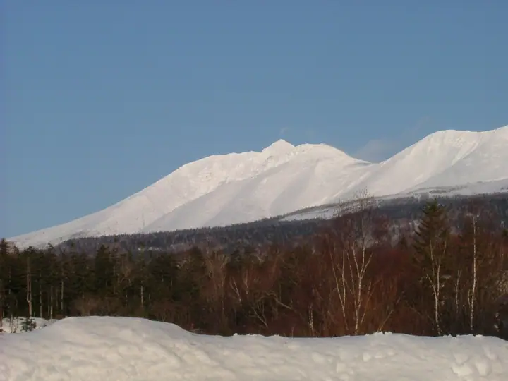
Mount Oputateshike is a 2,012 m peak straddling Biei and Shintoku towns in Kamikawa District, Hokkaido, sitting at the northern end of the Tokachi volcanic chain within Daisetsuzan National Park. Its sharp, spear-shaped silhouette gave it its Ainu name — "O-Putate-Shike," meaning "the place where a spear is thrust" — and it is listed in the Nihon Sanbyaku Meizan and the Hokkaidō Hyakumeizan. The mountain stands at the junction of the Tokachi main ridge and the long traverse to Tomuraushi-yama, with extensive haimatsu and alpine flower fields along the connecting crest. The standard ascent climbs from the Biei-Fuji trailhead at Shirogane Onsen, with a night at Biei-Fuji emergency shelter (about four hours from the trailhead) before the three-hour ridge to Bebetsu-dake and the summit. The peak is a key way-point on the celebrated Hokkaidō traverse linking Tokachi-dake, Oputateshike, Tomuraushi, and Kawunodake.
Mount Oputateshike at a glance
- Weather: The most settled day in the next 7 days is Thu, November 5: cloudy, gusts up to 9 m/s. Wed, Nov 4, Sat, Nov 7, Sun, Nov 8: strong wind (gusts up to 22 m/s).
- Route: The shortest is Mount Optateshike in the Tokachi Range, Return via the Biei-Fuji Hut and Ishigakiyama: about 11 h 45 min, 19.4 km, about 1,560 m of climbing.
Mount Oputateshike weather (hourly, 14 days)
Sunrise today 06:06, sunset 16:19
| Tue, 11/3 | Wed, 11/4 | Thu, 11/5 | Fri, 11/6 | Sat, 11/7 | Sun, 11/8 | Mon, 11/9 | Tue, 11/10 | Wed, 11/11 | Thu, 11/12 | Fri, 11/13 | Sat, 11/14 | Sun, 11/15 | Mon, 11/16 | Tue, 11/17 | |||||||||||||||||||||||||||||||||||||||||||||||||||||||||||||||||||||||
|---|---|---|---|---|---|---|---|---|---|---|---|---|---|---|---|---|---|---|---|---|---|---|---|---|---|---|---|---|---|---|---|---|---|---|---|---|---|---|---|---|---|---|---|---|---|---|---|---|---|---|---|---|---|---|---|---|---|---|---|---|---|---|---|---|---|---|---|---|---|---|---|---|---|---|---|---|---|---|---|---|---|---|---|---|---|
| Japan time | 15 | 17 | 19 | 21 | 23 | 1 | 3 | 5 | 7 | 9 | 11 | 13 | 15 | 18 | 21 | 0 | 3 | 6 | 9 | 12 | 15 | 18 | 21 | 0 | 3 | 6 | 9 | 12 | 15 | 18 | 21 | 0 | 3 | 6 | 9 | 12 | 15 | 18 | 21 | 0 | 3 | 6 | 9 | 12 | 15 | 18 | 21 | 0 | 3 | 6 | 9 | 15 | 21 | 3 | 9 | 15 | 21 | 3 | 9 | 15 | 21 | 3 | 9 | 15 | 21 | 3 | 9 | 15 | 21 | 3 | 9 | 15 | 21 | 3 | 9 | 15 | 21 | 3 | 9 | 15 | 21 | 3 | 9 | 15 | |
  |   | |   | | | | |   | | |   |  |   |  | | | |   | | | | |   | | |   | |   | |   | | | | | | | | | | | | | | | | | | | | | |   | |   | |   | | | | | | | | | | | |   |  | | | | | | | | |   | | | | |   | ||
| Temperature | °C | -8° | -10° | -11° | -11° | -11° | -11° | -10° | -9° | -9° | -8° | -7° | -7° | -7° | -14° | -12° | -11° | -11° | -10° | -2° | 1° | 0° | -4° | -4° | -3° | -3° | -3° | -1° | 1° | 0° | -3° | -7° | -10° | -12° | -12° | -12° | -12° | -12° | -13° | -13° | -13° | -14° | -14° | -12° | -11° | -12° | -12° | -12° | -12° | -13° | -13° | -12° | -12° | -17° | -15° | -11° | -11° | -16° | -13° | -9° | -8° | -17° | -16° | -9° | -9° | -13° | -14° | -14° | -12° | -13° | -17° | -9° | -8° | -12° | -10° | -2° | -3° | -3° | -4° | -4° | -8° | -12° | -12° | -11° | -10° |
| Precipitation | mm | 0.3 | 0.3 | 2.9 | 0.3 | 0.3 | 0.3 | 0.2 | 1.1 | 2.3 | 2.3 | 6 | 1.9 | 1.2 | 1.9 | 0.5 | 1.4 | 0.1 | 0.2 | 0.6 | 2.0 | 2.1 | 0.8 | 0.9 | 0.8 | 1.3 | 0.9 | 1.6 | 1.3 | 1.3 | 0.8 | 0.3 | 0.3 | 0.2 | 0.5 | 0.1 | 0.4 | 1.1 | 2.0 | 0.2 | 1.5 | 0.1 | 1.0 | 1.4 | 0.8 | 1.8 | 0.3 | 1.3 | 1.7 | 2.0 | 2.4 | 3.1 | 1.0 | 0.3 | |||||||||||||||||||||||||||||||
| New snow | cm | 0.3 | <.1 | 0.3 | 2.9 | 0.3 | 0.3 | 0.3 | 0.2 | <.1 | 0.1 | 1.3 | 0.1 | 0.2 | 0.6 | 2.0 | 2.1 | 0.8 | 0.9 | 0.8 | 1.3 | 0.9 | 1.6 | 1.3 | 1.3 | 0.7 | 0.3 | 0.3 | 0.2 | 0.1 | <.1 | 0.5 | 0.1 | 0.4 | <.1 | 1.1 | 2.0 | 0.2 | 1.5 | 0.1 | 0.8 | 1.4 | 0.8 | 1.8 | 0.2 | 2.4 | 3.1 | 0.9 | 0.3 | ||||||||||||||||||||||||||||||||||||
| Snow depth | cm | 10 | 10 | 10 | 10 | 10 | 10 | 13 | 13 | 13 | 13 | 13 | 13 | 13 | 12 | 12 | 12 | 12 | 12 | 12 | 11 | 10 | 9 | 9 | 9 | 8 | 8 | 7 | 6 | 5 | 4 | 4 | 5 | 5 | 5 | 6 | 7 | 9 | 9 | 10 | 10 | 11 | 12 | 14 | 14 | 15 | 15 | 15 | 16 | 15 | 15 | 15 | 15 | 15 | 15 | 15 | 14 | 14 | 15 | 17 | 16 | 16 | 16 | 16 | 16 | 16 | 17 | 18 | 18 | 20 | 19 | 19 | 19 | 18 | 18 | 18 | 16 | 15 | 14 | 13 | 15 | 17 | 18 | 18 | 18 |
| Wind | m/s | 4 | 2 | 1 | 2 | 1 | 0 | 2 | 3 | 5 | 5 | 5 | 4 | 2 | 1 | 0 | 0 | 0 | 0 | 1 | 2 | 1 | 1 | 1 | 1 | 1 | 1 | 1 | 1 | 3 | 4 | 5 | 6 | 4 | 4 | 5 | 5 | 5 | 6 | 6 | 6 | 6 | 6 | 5 | 6 | 5 | 4 | 4 | 3 | 3 | 2 | 2 | 3 | 1 | 1 | 1 | 1 | 1 | 2 | 2 | 0 | 1 | 1 | 2 | 3 | 2 | 3 | 5 | 4 | 3 | 2 | 2 | 1 | 1 | 1 | 2 | 2 | 2 | 1 | 1 | 3 | 3 | 4 | 3 | 1 |
| Wind gusts | m/s | 15 | 13 | 8 | 9 | 9 | 9 | 12 | 14 | 17 | 18 | 17 | 15 | 13 | 9 | 7 | 7 | 7 | 8 | 9 | 9 | 9 | 6 | 6 | 6 | 5 | 6 | 8 | 9 | 13 | 15 | 16 | 20 | 20 | 18 | 21 | 21 | 22 | 22 | 23 | 22 | 22 | 22 | 20 | 21 | 20 | 17 | 15 | 13 | 11 | 10 | 8 | 10 | 9 | 7 | 6 | 7 | 5 | 6 | 7 | 6 | 4 | 5 | 8 | 11 | 12 | 11 | 15 | 17 | 17 | 14 | 11 | 8 | 6 | 7 | 10 | 11 | 12 | 11 | 8 | 10 | 12 | 14 | 14 | 10 |
| Wind dir. | ↓ | ↓ | ↓ | ↓ | ↓ | ↓ | ↓ | ↓ | ↓ | ↓ | ↓ | ↓ | ↓ | ↓ | ↓ | ↓ | ↓ | ↓ | ↓ | ↓ | ↓ | ↓ | ↓ | ↓ | ↓ | ↓ | ↓ | ↓ | ↓ | ↓ | ↓ | ↓ | ↓ | ↓ | ↓ | ↓ | ↓ | ↓ | ↓ | ↓ | ↓ | ↓ | ↓ | ↓ | ↓ | ↓ | ↓ | ↓ | ↓ | ↓ | ↓ | ↓ | ↓ | ↓ | ↓ | ↓ | ↓ | ↓ | ↓ | ↓ | ↓ | ↓ | ↓ | ↓ | ↓ | ↓ | ↓ | ↓ | ↓ | ↓ | ↓ | ↓ | ↓ | ↓ | ↓ | ↓ | ↓ | ↓ | ↓ | ↓ | ↓ | ↓ | ↓ | ↓ | |
Mount Oputateshike hiking routes
Hiking times are estimates calculated from the terrain.
Huts, campsites and lodging near Mount Oputateshike
Mountain huts
Campsites
- Mt. Bieifuji Campground
Lists that include Mount Oputateshike
Japan's 300 Famous Mountains · Hokkaido 100 Famous Mountains · Elevations of 1003 Mountains of Japan · 1000 Mountains of Japan
Mount Oputateshike facts
- Also known as
- オプタテ
- Elevation
- 2,012 m
- Location
- Shintoku, Hokkaido
43.470261, 142.751541 - National Park
- 大雪山国立公園
- Website
- www.daisetsuzan.or.jp
- Trail Map
- hokkaido.env.go.jp (PDF)
- Wikipedia
- ja.wikipedia.org