
Mount Tomuraushi
トムラウシ山
Shintoku, Hokkaido · Elevation 2,141 m
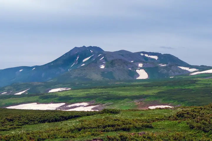
Mount Tomuraushi is a 2,141 m peak at the heart of the Daisetsuzan range and is often called the "inner sanctuary of Daisetsu." It is the only mountain in the Hyakumeizan list whose name is written in katakana, derived from Ainu and traditionally interpreted as "a place of many flowers." Approaches from Shintoku Town (the Tomuraushi Onsen and Tanshuku trailheads) and from Tenninkyō, as well as multi-day traverses across the Tokachi range, are all long routes that typically require overnight stays in emergency huts or tents. The summit plateau is famous for its rock gardens and alpine flora, and after the 2009 hypothermia incident, careful weather judgment and proper gear are emphasized.
Mount Tomuraushi at a glance
- Weather: The most settled day in the next 7 days is Thu, November 5: cloudy, gusts up to 10 m/s. Wed, Nov 4, Sat, Nov 7, Sun, Nov 8: strong wind (gusts up to 25 m/s).
- Route: The shortest is Mount Tomuraushi Return from the Short Course Trailhead: about 11 h 8 min, 18.2 km, about 1,510 m of climbing.
Mount Tomuraushi weather (hourly, 14 days)
Sunrise today 06:06, sunset 16:19
| Tue, 11/3 | Wed, 11/4 | Thu, 11/5 | Fri, 11/6 | Sat, 11/7 | Sun, 11/8 | Mon, 11/9 | Tue, 11/10 | Wed, 11/11 | Thu, 11/12 | Fri, 11/13 | Sat, 11/14 | Sun, 11/15 | Mon, 11/16 | Tue, 11/17 | |||||||||||||||||||||||||||||||||||||||||||||||||||||||||||||||||||||||
|---|---|---|---|---|---|---|---|---|---|---|---|---|---|---|---|---|---|---|---|---|---|---|---|---|---|---|---|---|---|---|---|---|---|---|---|---|---|---|---|---|---|---|---|---|---|---|---|---|---|---|---|---|---|---|---|---|---|---|---|---|---|---|---|---|---|---|---|---|---|---|---|---|---|---|---|---|---|---|---|---|---|---|---|---|---|
| Japan time | 15 | 17 | 19 | 21 | 23 | 1 | 3 | 5 | 7 | 9 | 11 | 13 | 15 | 18 | 21 | 0 | 3 | 6 | 9 | 12 | 15 | 18 | 21 | 0 | 3 | 6 | 9 | 12 | 15 | 18 | 21 | 0 | 3 | 6 | 9 | 12 | 15 | 18 | 21 | 0 | 3 | 6 | 9 | 12 | 15 | 18 | 21 | 0 | 3 | 6 | 9 | 15 | 21 | 3 | 9 | 15 | 21 | 3 | 9 | 15 | 21 | 3 | 9 | 15 | 21 | 3 | 9 | 15 | 21 | 3 | 9 | 15 | 21 | 3 | 9 | 15 | 21 | 3 | 9 | 15 | 21 | 3 | 9 | 15 | |
  |   | |   | | | | | | | | |   |  | |   | | | | |   | | |   | | |   | |   |   | | | | | | | | | | | | | | | | | | | | | | | | |   |  |   | | | | | | | | | | | |   |  | | | | | | | | |   | | | | | | ||
| Temperature | °C | -9° | -11° | -11° | -12° | -11° | -11° | -10° | -10° | -10° | -9° | -8° | -8° | -7° | -14° | -12° | -12° | -11° | -10° | -2° | 1° | 0° | -2° | -1° | -1° | -1° | -1° | 0° | 0° | 0° | -3° | -6° | -9° | -12° | -13° | -12° | -13° | -13° | -13° | -13° | -13° | -14° | -14° | -12° | -12° | -12° | -12° | -12° | -13° | -13° | -13° | -13° | -12° | -18° | -15° | -12° | -11° | -16° | -14° | -9° | -8° | -17° | -17° | -10° | -9° | -13° | -14° | -15° | -13° | -14° | -18° | -10° | -8° | -12° | -12° | -2° | -2° | -2° | -3° | -3° | -7° | -12° | -12° | -11° | -10° |
| Precipitation | mm | 0.2 | 0.5 | 0.3 | 1.9 | 0.7 | 0.6 | 0.5 | 0.4 | 0.9 | 2.2 | 2.4 | 4.6 | 1.7 | 0.6 | 2.5 | 1.5 | 1.5 | 0.2 | 0.2 | 1.1 | 3.1 | 1.6 | 0.5 | 0.5 | 0.6 | 1.3 | 1.3 | 3.0 | 2.9 | 2.4 | 1.9 | 0.6 | 0.4 | 0.2 | 0.1 | 0.6 | 0.5 | 0.6 | 0.1 | 1.0 | 1.8 | 0.1 | 1.3 | 0.2 | 1.2 | 1.9 | 1.4 | 1.8 | 0.2 | 0.2 | 1.4 | 1.8 | 2.4 | 2.6 | 3.6 | 1.3 | 0.2 | |||||||||||||||||||||||||||
| New snow | cm | 0.2 | 0.5 | <.1 | 0.3 | 1.9 | 0.7 | 0.6 | 0.5 | 0.4 | <.1 | 0.4 | 1.1 | 1.5 | 0.2 | 0.2 | 1.1 | 3.1 | 1.6 | 0.5 | 0.5 | 0.6 | 1.3 | 1.2 | 3.0 | 2.9 | 2.4 | 1.8 | 0.6 | 0.4 | 0.2 | 0.1 | <.1 | 0.6 | 0.4 | 0.5 | 0.1 | 1.0 | 1.8 | 0.1 | 1.3 | 0.2 | 1.1 | 1.9 | 1.4 | 1.8 | 0.3 | 1.4 | 2.6 | 3.6 | 1.1 | 0.2 | |||||||||||||||||||||||||||||||||
| Snow depth | cm | 27 | 27 | 27 | 27 | 27 | 28 | 29 | 30 | 30 | 31 | 31 | 30 | 30 | 30 | 30 | 30 | 30 | 29 | 29 | 28 | 27 | 26 | 26 | 26 | 26 | 25 | 24 | 23 | 21 | 21 | 21 | 22 | 23 | 23 | 24 | 27 | 28 | 28 | 28 | 29 | 30 | 31 | 34 | 36 | 38 | 39 | 40 | 39 | 39 | 39 | 38 | 38 | 38 | 38 | 37 | 37 | 36 | 37 | 39 | 38 | 37 | 37 | 37 | 37 | 37 | 38 | 40 | 41 | 42 | 41 | 41 | 40 | 40 | 39 | 39 | 37 | 36 | 35 | 36 | 37 | 40 | 41 | 41 | 40 |
| Wind | m/s | 3 | 2 | 2 | 1 | 1 | 1 | 3 | 4 | 5 | 5 | 4 | 4 | 2 | 1 | 1 | 1 | 1 | 0 | 1 | 2 | 1 | 1 | 1 | 1 | 1 | 1 | 1 | 1 | 2 | 4 | 5 | 6 | 6 | 5 | 5 | 6 | 7 | 9 | 8 | 7 | 7 | 6 | 6 | 6 | 5 | 4 | 4 | 3 | 3 | 2 | 1 | 2 | 1 | 1 | 1 | 0 | 1 | 2 | 2 | 1 | 1 | 1 | 1 | 3 | 1 | 2 | 5 | 4 | 3 | 2 | 1 | 1 | 1 | 1 | 3 | 3 | 3 | 1 | 1 | 2 | 3 | 4 | 2 | 1 |
| Wind gusts | m/s | 15 | 12 | 8 | 9 | 9 | 9 | 13 | 16 | 19 | 18 | 16 | 14 | 13 | 9 | 8 | 8 | 8 | 8 | 7 | 9 | 10 | 6 | 5 | 5 | 4 | 6 | 8 | 9 | 11 | 16 | 18 | 21 | 22 | 21 | 20 | 21 | 25 | 27 | 28 | 26 | 24 | 24 | 21 | 22 | 21 | 17 | 14 | 13 | 10 | 10 | 7 | 8 | 8 | 6 | 5 | 6 | 4 | 5 | 7 | 6 | 4 | 5 | 6 | 10 | 12 | 10 | 15 | 17 | 17 | 13 | 9 | 7 | 6 | 6 | 11 | 13 | 13 | 11 | 8 | 8 | 11 | 13 | 13 | 8 |
| Wind dir. | ↓ | ↓ | ↓ | ↓ | ↓ | ↓ | ↓ | ↓ | ↓ | ↓ | ↓ | ↓ | ↓ | ↓ | ↓ | ↓ | ↓ | ↓ | ↓ | ↓ | ↓ | ↓ | ↓ | ↓ | ↓ | ↓ | ↓ | ↓ | ↓ | ↓ | ↓ | ↓ | ↓ | ↓ | ↓ | ↓ | ↓ | ↓ | ↓ | ↓ | ↓ | ↓ | ↓ | ↓ | ↓ | ↓ | ↓ | ↓ | ↓ | ↓ | ↓ | ↓ | ↓ | ↓ | ↓ | ↓ | ↓ | ↓ | ↓ | ↓ | ↓ | ↓ | ↓ | ↓ | ↓ | ↓ | ↓ | ↓ | ↓ | ↓ | ↓ | ↓ | ↓ | ↓ | ↓ | ↓ | ↓ | ↓ | ↓ | ↓ | ↓ | ↓ | ↓ | ↓ | |
Mount Tomuraushi hiking routes
Hiking times are estimates calculated from the terrain.
Huts, campsites and lodging near Mount Tomuraushi
Mountain huts
Lists that include Mount Tomuraushi
100 Famous Japanese Mountains · Japan 200 Famous Mountains · Japan's 300 Famous Mountains · 100 Famous Mountains with First-order Triangulation Points · 100 Famous Hot Spring Mountains · Hokkaido 100 Famous Mountains · Elevations of 1003 Mountains of Japan · 1000 Mountains of Japan
Mount Tomuraushi facts
- Elevation
- 2,141 m
- Location
- Shintoku, Hokkaido
43.527140, 142.848793 - National Park
- 大雪山国立公園
- Website
- shintoku-town.net
- Trail Map
- www.env.go.jp (PDF)
- Access Information
- shintoku-town.net
- Wikipedia
- en.wikipedia.org