
Mount Nikko-Shirane
日光白根山
Katashina, Gunma · Elevation 2,578 m
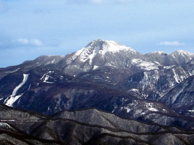
Okushirane is the main summit of Mount Nikkō-Shirane, a 2,578 m peak on the border of Nikkō in Tochigi and Katashina in Gunma. An active volcano at the northwestern end of the Nikkō volcanic group, it is the highest mountain from northern Kantō northward. Several model routes start from the upper station of the Marunuma Kōgen ropeway.
Mount Nikko-Shirane at a glance
- Weather: The most settled day in the next 7 days is Wed, November 4: clear, gusts up to 9 m/s. Sat, Nov 7: strong wind (gusts up to 22 m/s).
- Route: The shortest is Mount Nikko-Shirane Ropeway Summit Station Loop: about 4 h 15 min, 6.6 km, about 620 m of climbing.
Mount Nikko-Shirane weather (hourly, 14 days)
Sunrise today 06:07, sunset 16:45
| Tue, 11/3 | Wed, 11/4 | Thu, 11/5 | Fri, 11/6 | Sat, 11/7 | Sun, 11/8 | Mon, 11/9 | Tue, 11/10 | Wed, 11/11 | Thu, 11/12 | Fri, 11/13 | Sat, 11/14 | Sun, 11/15 | Mon, 11/16 | Tue, 11/17 | |||||||||||||||||||||||||||||||||||||||||||||||||||||||||||||||||||||||
|---|---|---|---|---|---|---|---|---|---|---|---|---|---|---|---|---|---|---|---|---|---|---|---|---|---|---|---|---|---|---|---|---|---|---|---|---|---|---|---|---|---|---|---|---|---|---|---|---|---|---|---|---|---|---|---|---|---|---|---|---|---|---|---|---|---|---|---|---|---|---|---|---|---|---|---|---|---|---|---|---|---|---|---|---|---|
| Japan time | 15 | 17 | 19 | 21 | 23 | 1 | 3 | 5 | 7 | 9 | 11 | 13 | 15 | 18 | 21 | 0 | 3 | 6 | 9 | 12 | 15 | 18 | 21 | 0 | 3 | 6 | 9 | 12 | 15 | 18 | 21 | 0 | 3 | 6 | 9 | 12 | 15 | 18 | 21 | 0 | 3 | 6 | 9 | 12 | 15 | 18 | 21 | 0 | 3 | 6 | 9 | 15 | 21 | 3 | 9 | 15 | 21 | 3 | 9 | 15 | 21 | 3 | 9 | 15 | 21 | 3 | 9 | 15 | 21 | 3 | 9 | 15 | 21 | 3 | 9 | 15 | 21 | 3 | 9 | 15 | 21 | 3 | 9 | 15 | |
 |  |   | | | | | | |   | | |   |   |   | | | |   | | |   | | | | | | | | | | | |   |   | | | | | | | | | | | | | | |   | |   | | | | | | | | | | | | | | |   | | | | | |  | | | | |   | |   |   | | | | ||
| Temperature | °C | 0° | -4° | -6° | -6° | -6° | -6° | -6° | -6° | -4° | 1° | 3° | 4° | 2° | -2° | -2° | -2° | -1° | 0° | 3° | 5° | 5° | 1° | 1° | 1° | 1° | -1° | 3° | 6° | 3° | 0° | -2° | -4° | -6° | -7° | -6° | -6° | -7° | -8° | -9° | -9° | -9° | -9° | -5° | -2° | -3° | -7° | -7° | -6° | -6° | -6° | -2° | -1° | -5° | -6° | -3° | -3° | -5° | -6° | -7° | -6° | -8° | -8° | -3° | -2° | -7° | -6° | -4° | -7° | -9° | -10° | -1° | 0° | -7° | -5° | 1° | 2° | -1° | 0° | 5° | 0° | -7° | -9° | -2° | -2° |
| Precipitation | mm | 0.4 | 0.9 | 8 | 8 | 1.7 | 0.2 | 0.1 | 0.2 | 0.4 | 0.5 | 0.3 | 0.1 | 0.4 | 2.5 | 3.0 | 0.4 | 0.8 | 4.6 | 8 | 0.4 | 1.3 | |||||||||||||||||||||||||||||||||||||||||||||||||||||||||||||||
| New snow | cm | <.1 | 0.2 | 0.4 | 0.5 | 0.3 | 0.1 | <.1 | <.1 | <.1 | 0.4 | 2.5 | 2.9 | 0.3 | 0.7 | <.1 | 0.4 | ||||||||||||||||||||||||||||||||||||||||||||||||||||||||||||||||||||
| Snow depth | cm | 0 | 0 | 0 | 0 | 0 | 0 | 0 | 0 | 0 | 0 | 0 | 0 | 0 | 0 | 0 | 0 | 0 | 0 | 0 | 0 | 0 | 0 | 0 | 0 | 0 | 0 | 0 | 0 | 0 | 0 | 0 | 0 | 0 | 0 | 0 | <1 | <1 | <1 | <1 | <1 | <1 | <1 | <1 | <1 | <1 | <1 | <1 | <1 | <1 | <1 | <1 | <1 | <1 | <1 | <1 | 0 | 0 | <1 | 2 | 3 | 3 | 3 | 3 | 3 | 2 | 2 | 3 | 3 | 2 | 2 | 2 | 2 | 2 | 2 | 2 | <1 | <1 | <1 | <1 | 0 | <1 | <1 | <1 | <1 |
| Wind | m/s | 1 | 1 | 1 | 0 | 0 | 1 | 1 | 1 | 0 | 1 | 2 | 3 | 2 | 1 | 1 | 1 | 1 | 2 | 1 | 1 | 1 | 1 | 0 | 0 | 1 | 2 | 4 | 4 | 3 | 2 | 3 | 4 | 4 | 4 | 6 | 7 | 7 | 5 | 4 | 3 | 3 | 3 | 2 | 2 | 1 | 1 | 1 | 0 | 1 | 0 | 1 | 1 | 0 | 1 | 1 | 2 | 2 | 3 | 6 | 7 | 3 | 2 | 1 | 1 | 1 | 1 | 4 | 5 | 3 | 2 | 1 | 1 | 1 | 1 | 1 | 2 | 1 | 2 | 1 | 6 | 5 | 3 | 1 | 2 |
| Wind gusts | m/s | 8 | 6 | 4 | 4 | 4 | 4 | 4 | 4 | 3 | 5 | 7 | 8 | 9 | 7 | 7 | 8 | 6 | 7 | 7 | 6 | 6 | 6 | 4 | 5 | 5 | 6 | 12 | 13 | 12 | 9 | 9 | 13 | 15 | 16 | 18 | 22 | 22 | 20 | 16 | 15 | 13 | 12 | 11 | 10 | 9 | 6 | 6 | 6 | 6 | 7 | 7 | 8 | 5 | 4 | 5 | 8 | 9 | 10 | 22 | 25 | 23 | 10 | 7 | 7 | 5 | 6 | 12 | 16 | 15 | 10 | 8 | 6 | 6 | 4 | 6 | 9 | 7 | 9 | 9 | 20 | 18 | 16 | 8 | 7 |
| Wind dir. | ↓ | ↓ | ↓ | ↓ | ↓ | ↓ | ↓ | ↓ | ↓ | ↓ | ↓ | ↓ | ↓ | ↓ | ↓ | ↓ | ↓ | ↓ | ↓ | ↓ | ↓ | ↓ | ↓ | ↓ | ↓ | ↓ | ↓ | ↓ | ↓ | ↓ | ↓ | ↓ | ↓ | ↓ | ↓ | ↓ | ↓ | ↓ | ↓ | ↓ | ↓ | ↓ | ↓ | ↓ | ↓ | ↓ | ↓ | ↓ | ↓ | ↓ | ↓ | ↓ | ↓ | ↓ | ↓ | ↓ | ↓ | ↓ | ↓ | ↓ | ↓ | ↓ | ↓ | ↓ | ↓ | ↓ | ↓ | ↓ | ↓ | ↓ | ↓ | ↓ | ↓ | ↓ | ↓ | ↓ | ↓ | ↓ | ↓ | ↓ | ↓ | ↓ | ↓ | ↓ | |
Mount Nikko-Shirane live cameras
Mount Nikko-Shirane hiking routes
- Mount Nikko-Shirane Ropeway Summit Station Loop 6.6 km · Ascent 622 m 日光白根山ロープウェイ 山頂駅 (Aerialway station)
- Mount Nikko-Shirane Loop via Goshikinuma and Midagahike 8.9 km · Ascent 754 m 日光白根山ロープウェイ 山頂駅 (Aerialway station)
- Mount Nikko-Shirane and Goshiki Pond Loop from Sugenuma 9.1 km · Ascent 936 m 菅沼登山口有料駐車場
- Mount Nikko-Shirane Circuit from Konsei Pass via Mount Konsei and Mount Mae-Shirane 10.9 km · Ascent 1,344 m 金精峠登山口
Hiking times are estimates calculated from the terrain.
Huts, campsites and lodging near Mount Nikko-Shirane
Mountain huts
Campsites
- Suganuma Camp Village
- 丸沼高原オートキャンプ場
- 湯元キャンプ場
Lodging
- 湯の森
- かつら荘
- 実のや
- 樹林
- Kyukamura Nikko Yumoto
Lists that include Mount Nikko-Shirane
100 Famous Japanese Mountains · Japan 200 Famous Mountains · Japan's 300 Famous Mountains · New 100 Famous Flower Mountains · Highest Peaks by Prefecture · 100 Famous Hot Spring Mountains · Kanto 100 Famous Mountains · Gunma 100 Famous Mountains · Tochigi 100 Famous Mountains · Tochigi's Top 5 Mountains · Elevations of 1003 Mountains of Japan · 1000 Mountains of Japan
Mount Nikko-Shirane facts
- Also known as
- Mount Okushirane
- Elevation
- 2,578 m
- Location
- Katashina, Gunma
36.798615, 139.375922 - Volcano
- Active volcano (日光白根山)
- Website
- www.marunuma.jp
- Access Information
- www.marunuma.jp
- Wikipedia
- ja.wikipedia.org