
Mount Nanashigure (South Peak)
七時雨山 南峰
Hachimantai, Iwate · Elevation 1,063 m
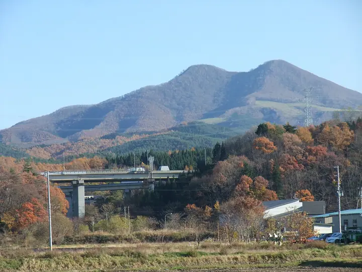
The South Peak of Mount Nanashigure is the 1,063-meter twin to the 1,060-meter North Peak (the location of the first-order triangulation point) in Hachimantai City, Iwate Prefecture. The peak is a lava dome of the roughly one-million-year-old Nanashigure volcano, overlooking the broad Tashiroidaira caldera grassland; its summit shrine holds a stone lion-head Gongen figure paired with the one on Mount Iwate. An annual opening ceremony hosted by Hachimantai City is held on the fourth Sunday of May, and the mountain features on the Tōhoku Hyakumeizan and Shin-Nihon Hyakumeizan lists.
Mount Nanashigure (South Peak) at a glance
- Weather: The most settled day in the next 7 days is Wed, November 4: clear, gusts up to 9 m/s. Sat, Nov 7, Sun, Nov 8: strong wind (gusts up to 22 m/s).
Mount Nanashigure (South Peak) weather (hourly, 14 days)
Sunrise today 06:06, sunset 16:32
| Tue, 11/3 | Wed, 11/4 | Thu, 11/5 | Fri, 11/6 | Sat, 11/7 | Sun, 11/8 | Mon, 11/9 | Tue, 11/10 | Wed, 11/11 | Thu, 11/12 | Fri, 11/13 | Sat, 11/14 | Sun, 11/15 | Mon, 11/16 | Tue, 11/17 | |||||||||||||||||||||||||||||||||||||||||||||||||||||||||||||||||||||||
|---|---|---|---|---|---|---|---|---|---|---|---|---|---|---|---|---|---|---|---|---|---|---|---|---|---|---|---|---|---|---|---|---|---|---|---|---|---|---|---|---|---|---|---|---|---|---|---|---|---|---|---|---|---|---|---|---|---|---|---|---|---|---|---|---|---|---|---|---|---|---|---|---|---|---|---|---|---|---|---|---|---|---|---|---|---|
| Japan time | 15 | 17 | 19 | 21 | 23 | 1 | 3 | 5 | 7 | 9 | 11 | 13 | 15 | 18 | 21 | 0 | 3 | 6 | 9 | 12 | 15 | 18 | 21 | 0 | 3 | 6 | 9 | 12 | 15 | 18 | 21 | 0 | 3 | 6 | 9 | 12 | 15 | 18 | 21 | 0 | 3 | 6 | 9 | 12 | 15 | 18 | 21 | 0 | 3 | 6 | 9 | 15 | 21 | 3 | 9 | 15 | 21 | 3 | 9 | 15 | 21 | 3 | 9 | 15 | 21 | 3 | 9 | 15 | 21 | 3 | 9 | 15 | 21 | 3 | 9 | 15 | 21 | 3 | 9 | 15 | 21 | 3 | 9 | 15 | |
  |  | | | | |   | | |  | | | | | | | |   |   | | |   | | |   | |   | | | | | | |   |   | |   |   |   | | |   |   |   | |   | | | |   | | | | | | | | | | |   | | |   | | | | | | | | |  | | | | | | | | | | | | ||
| Temperature | °C | 5° | 2° | 2° | 1° | 0° | -2° | -1° | 0° | 2° | 7° | 9° | 10° | 9° | 2° | 0° | 1° | 3° | 5° | 6° | 7° | 7° | 7° | 6° | 7° | 6° | 6° | 9° | 11° | 10° | 5° | 2° | 1° | 0° | -1° | 0° | 1° | -1° | -2° | -2° | -2° | -2° | -2° | 0° | 2° | 1° | 0° | 0° | 0° | 0° | -2° | 1° | 1° | -3° | -3° | 0° | 4° | 0° | 0° | -2° | -1° | -3° | -4° | 1° | 3° | -2° | 0° | 0° | 1° | -3° | -5° | 1° | 5° | -4° | -6° | 3° | 7° | 2° | 2° | 4° | 1° | -3° | -3° | 1° | 2° |
| Precipitation | mm | 3.0 | 3.9 | 1.7 | 3.0 | 1.1 | 1.6 | 1.0 | 1.4 | 0.6 | 0.3 | 0.7 | 0.5 | 0.4 | 0.7 | 0.9 | 1.1 | 1.4 | 0.7 | 0.4 | 1.2 | 1.2 | 0.3 | 0.1 | 0.3 | 7 | 12 | 6 | 0.2 | 0.2 | 0.1 | 2.6 | 0.3 | 0.8 | 0.6 | 1.8 | 2.6 | ||||||||||||||||||||||||||||||||||||||||||||||||
| New snow | cm | <.1 | <.1 | 0.4 | 0.7 | 1.1 | 0.6 | 0.4 | 1.1 | 1.1 | 0.3 | <.1 | <.1 | 0.2 | 0.6 | 3.6 | 3.0 | <.1 | 0.2 | ||||||||||||||||||||||||||||||||||||||||||||||||||||||||||||||||||
| Snow depth | cm | 0 | 0 | 0 | 0 | 0 | 0 | 0 | 0 | 0 | 0 | 0 | 0 | 0 | 0 | 0 | 0 | 0 | 0 | 0 | 0 | 0 | 0 | 0 | 0 | 0 | 0 | 0 | 0 | 0 | 0 | 0 | 0 | 0 | 0 | <1 | <1 | <1 | <1 | <1 | 1 | 1 | 1 | <1 | <1 | <1 | <1 | <1 | 0 | 0 | 0 | 0 | 0 | 0 | 0 | 0 | 0 | 0 | <1 | 2 | 2 | 1 | 1 | 1 | <1 | <1 | <1 | <1 | 0 | 0 | 0 | 0 | 0 | 0 | 0 | 0 | 0 | 0 | 0 | 0 | 0 | <1 | <1 | <1 | 0 |
| Wind | m/s | 6 | 4 | 3 | 3 | 1 | 2 | 2 | 2 | 2 | 3 | 3 | 4 | 2 | 0 | 0 | 2 | 3 | 4 | 3 | 2 | 1 | 1 | 0 | 1 | 1 | 1 | 2 | 2 | 4 | 7 | 7 | 6 | 6 | 5 | 6 | 8 | 5 | 5 | 5 | 5 | 5 | 5 | 8 | 10 | 8 | 5 | 3 | 3 | 3 | 1 | 5 | 4 | 2 | 1 | 1 | 1 | 3 | 2 | 6 | 4 | 1 | 1 | 1 | 3 | 1 | 1 | 5 | 5 | 3 | 1 | 1 | 3 | 0 | 0 | 1 | 3 | 2 | 1 | 1 | 5 | 4 | 3 | 4 | 3 |
| Wind gusts | m/s | 15 | 13 | 9 | 7 | 6 | 5 | 5 | 7 | 6 | 7 | 9 | 9 | 9 | 4 | 2 | 5 | 7 | 10 | 11 | 9 | 5 | 2 | 2 | 4 | 3 | 2 | 5 | 11 | 11 | 15 | 16 | 17 | 15 | 13 | 16 | 20 | 18 | 15 | 13 | 13 | 13 | 13 | 17 | 22 | 22 | 18 | 12 | 8 | 8 | 8 | 11 | 11 | 9 | 5 | 4 | 7 | 11 | 9 | 14 | 14 | 9 | 3 | 4 | 10 | 7 | 4 | 12 | 13 | 12 | 7 | 4 | 8 | 6 | 2 | 4 | 8 | 6 | 6 | 4 | 13 | 12 | 10 | 8 | 11 |
| Wind dir. | ↓ | ↓ | ↓ | ↓ | ↓ | ↓ | ↓ | ↓ | ↓ | ↓ | ↓ | ↓ | ↓ | ↓ | ↓ | ↓ | ↓ | ↓ | ↓ | ↓ | ↓ | ↓ | ↓ | ↓ | ↓ | ↓ | ↓ | ↓ | ↓ | ↓ | ↓ | ↓ | ↓ | ↓ | ↓ | ↓ | ↓ | ↓ | ↓ | ↓ | ↓ | ↓ | ↓ | ↓ | ↓ | ↓ | ↓ | ↓ | ↓ | ↓ | ↓ | ↓ | ↓ | ↓ | ↓ | ↓ | ↓ | ↓ | ↓ | ↓ | ↓ | ↓ | ↓ | ↓ | ↓ | ↓ | ↓ | ↓ | ↓ | ↓ | ↓ | ↓ | ↓ | ↓ | ↓ | ↓ | ↓ | ↓ | ↓ | ↓ | ↓ | ↓ | ↓ | ↓ | |
Huts, campsites and lodging near Mount Nanashigure (South Peak)
Mountain huts
Lists that include Mount Nanashigure (South Peak)
Mount Nanashigure (South Peak) facts
- Elevation
- 1,063 m
- Location
- Hachimantai, Iwate
40.069254, 141.105668 - Website
- www.hachimantai.or.jp
- Trail Map
- www.hachimantai.or.jp (PDF)
- Access Information
- www.tohokukanko.jp
- Wikipedia
- ja.wikipedia.org