
Mount Memuro
芽室岳
Memuro, Hokkaido · Elevation 1,753 m
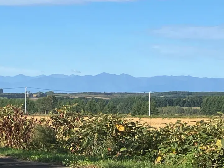
Mount Memuro is a 1,753.5 m peak at the meeting point of Shimizu, Memuro, and Hidaka towns in southern Hokkaido — a prominent summit of the northern Hidaka Range. The summit carries a first-class triangulation point and its symmetrical pyramid is conspicuous from the northern Tokachi plain. The trail from the Omabetsu Forest Road was closed for years after typhoon damage in 2016 and reopened in 2022 through the efforts of local alpine clubs and authorities. The mountain lies within Hidaka-Sanmyaku-Erimo-Tokachi National Park, newly designated in 2024, and is counted among the 100 Famous Mountains of Hokkaido.
Mount Memuro at a glance
- Weather: The most settled day in the next 7 days is Thu, November 5: cloudy, gusts up to 9 m/s. Wed, Nov 4, Sat, Nov 7, Sun, Nov 8, Mon, Nov 9: strong wind (gusts up to 26 m/s).
- Route: The shortest is Mount Memuro North Ridge: about 6 h 24 min, 9.0 km, about 1,160 m of climbing.
Mount Memuro weather (hourly, 14 days)
Sunrise today 06:05, sunset 16:20
| Tue, 11/3 | Wed, 11/4 | Thu, 11/5 | Fri, 11/6 | Sat, 11/7 | Sun, 11/8 | Mon, 11/9 | Tue, 11/10 | Wed, 11/11 | Thu, 11/12 | Fri, 11/13 | Sat, 11/14 | Sun, 11/15 | Mon, 11/16 | Tue, 11/17 | |||||||||||||||||||||||||||||||||||||||||||||||||||||||||||||||||||||||
|---|---|---|---|---|---|---|---|---|---|---|---|---|---|---|---|---|---|---|---|---|---|---|---|---|---|---|---|---|---|---|---|---|---|---|---|---|---|---|---|---|---|---|---|---|---|---|---|---|---|---|---|---|---|---|---|---|---|---|---|---|---|---|---|---|---|---|---|---|---|---|---|---|---|---|---|---|---|---|---|---|---|---|---|---|---|
| Japan time | 15 | 17 | 19 | 21 | 23 | 1 | 3 | 5 | 7 | 9 | 11 | 13 | 15 | 18 | 21 | 0 | 3 | 6 | 9 | 12 | 15 | 18 | 21 | 0 | 3 | 6 | 9 | 12 | 15 | 18 | 21 | 0 | 3 | 6 | 9 | 12 | 15 | 18 | 21 | 0 | 3 | 6 | 9 | 12 | 15 | 18 | 21 | 0 | 3 | 6 | 9 | 15 | 21 | 3 | 9 | 15 | 21 | 3 | 9 | 15 | 21 | 3 | 9 | 15 | 21 | 3 | 9 | 15 | 21 | 3 | 9 | 15 | 21 | 3 | 9 | 15 | 21 | 3 | 9 | 15 | 21 | 3 | 9 | 15 | |
  |   |   | |   |   | | |   | | |  | |  | | | | |   |   | | |   | | | | | |   | |   | |   | | | | | | | | | | | | | | | | | |   | | | |   | | | | | | | | | | | | | | | | | |  | | | | | | |   | | |   | | ||
| Temperature | °C | -5° | -8° | -9° | -8° | -9° | -7° | -6° | -6° | -6° | -6° | -5° | -3° | -4° | -9° | -7° | -7° | -6° | -5° | 2° | 2° | 2° | 0° | 0° | 0° | 0° | 0° | 2° | 4° | 2° | 0° | -4° | -7° | -10° | -10° | -9° | -8° | -9° | -10° | -10° | -11° | -11° | -11° | -10° | -9° | -9° | -10° | -10° | -11° | -12° | -11° | -9° | -9° | -13° | -12° | -9° | -6° | -9° | -10° | -8° | -5° | -10° | -11° | -7° | -6° | -10° | -10° | -11° | -10° | -10° | -12° | -6° | -4° | -8° | -7° | -1° | -1° | -1° | -2° | -1° | -5° | -10° | -10° | -7° | -6° |
| Precipitation | mm | 0.2 | 2.7 | 0.2 | 0.2 | 0.1 | 0.2 | 1.0 | 3.4 | 1.6 | 1.6 | 3.6 | 1.2 | 0.7 | 1.3 | 0.3 | 0.1 | 0.2 | 0.2 | 1.2 | 1.0 | 0.1 | 0.4 | 0.4 | 0.3 | 0.4 | 0.4 | 0.4 | 0.4 | 0.5 | 0.3 | 0.1 | 0.1 | 2.8 | 3.3 | 0.4 | 0.1 | 0.9 | 0.2 | 0.1 | 0.2 | 0.2 | 0.1 | 0.1 | 0.3 | 6 | 1.6 | 0.7 | 2.2 | 0.3 | |||||||||||||||||||||||||||||||||||
| New snow | cm | <.1 | 0.2 | 2.7 | 0.2 | <.1 | 0.2 | <.1 | <.1 | 0.1 | 0.1 | 0.2 | 1.2 | 1.0 | 0.1 | 0.4 | 0.4 | 0.3 | 0.4 | 0.4 | 0.4 | 0.5 | 0.5 | 0.3 | 0.1 | <.1 | 0.1 | <.1 | 2.8 | 3.3 | 0.4 | 0.1 | 0.9 | 0.2 | <.1 | 0.2 | 0.2 | <.1 | <.1 | 1.7 | 0.3 | <.1 | |||||||||||||||||||||||||||||||||||||||||||
| Snow depth | cm | 2 | 2 | 2 | 2 | 2 | 2 | 5 | 5 | 5 | 5 | 5 | 5 | 4 | 4 | 4 | 4 | 4 | 4 | 4 | 3 | 2 | 2 | 2 | 1 | 1 | <1 | <1 | <1 | 0 | 0 | 0 | 0 | 0 | <1 | <1 | 1 | 2 | 2 | 2 | 3 | 3 | 3 | 3 | 3 | 4 | 4 | 4 | 4 | 4 | 4 | 4 | 4 | 4 | 4 | 4 | 3 | 3 | 6 | 8 | 8 | 8 | 8 | 7 | 8 | 8 | 8 | 8 | 7 | 7 | 7 | 7 | 7 | 7 | 7 | 6 | 5 | 4 | 4 | 3 | 4 | 4 | 4 | 4 | 4 |
| Wind | m/s | 6 | 4 | 3 | 4 | 3 | 4 | 4 | 5 | 6 | 6 | 5 | 4 | 1 | 2 | 2 | 2 | 3 | 2 | 2 | 1 | 1 | 1 | 1 | 1 | 1 | 1 | 1 | 2 | 4 | 7 | 10 | 9 | 8 | 6 | 7 | 8 | 9 | 9 | 8 | 8 | 8 | 8 | 8 | 8 | 8 | 7 | 5 | 4 | 3 | 3 | 3 | 5 | 2 | 2 | 1 | 1 | 1 | 3 | 2 | 0 | 1 | 1 | 2 | 3 | 3 | 2 | 6 | 5 | 3 | 2 | 1 | 1 | 1 | 2 | 2 | 3 | 2 | 2 | 1 | 3 | 3 | 3 | 1 | 1 |
| Wind gusts | m/s | 18 | 18 | 13 | 14 | 14 | 14 | 16 | 16 | 20 | 20 | 19 | 16 | 14 | 8 | 9 | 11 | 11 | 11 | 9 | 9 | 7 | 6 | 5 | 4 | 4 | 5 | 7 | 12 | 14 | 22 | 27 | 29 | 27 | 24 | 22 | 24 | 26 | 30 | 28 | 27 | 26 | 26 | 26 | 25 | 24 | 25 | 22 | 17 | 14 | 11 | 11 | 15 | 15 | 9 | 7 | 7 | 5 | 9 | 8 | 6 | 4 | 6 | 8 | 11 | 11 | 11 | 17 | 17 | 16 | 13 | 9 | 6 | 6 | 8 | 11 | 12 | 12 | 10 | 7 | 9 | 12 | 11 | 10 | 6 |
| Wind dir. | ↓ | ↓ | ↓ | ↓ | ↓ | ↓ | ↓ | ↓ | ↓ | ↓ | ↓ | ↓ | ↓ | ↓ | ↓ | ↓ | ↓ | ↓ | ↓ | ↓ | ↓ | ↓ | ↓ | ↓ | ↓ | ↓ | ↓ | ↓ | ↓ | ↓ | ↓ | ↓ | ↓ | ↓ | ↓ | ↓ | ↓ | ↓ | ↓ | ↓ | ↓ | ↓ | ↓ | ↓ | ↓ | ↓ | ↓ | ↓ | ↓ | ↓ | ↓ | ↓ | ↓ | ↓ | ↓ | ↓ | ↓ | ↓ | ↓ | ↓ | ↓ | ↓ | ↓ | ↓ | ↓ | ↓ | ↓ | ↓ | ↓ | ↓ | ↓ | ↓ | ↓ | ↓ | ↓ | ↓ | ↓ | ↓ | ↓ | ↓ | ↓ | ↓ | ↓ | ↓ | |
Mount Memuro hiking routes
Hiking times are estimates calculated from the terrain.
Lists that include Mount Memuro
Hokkaido 100 Famous Mountains · Elevations of 1003 Mountains of Japan · 1000 Mountains of Japan
Mount Memuro facts
- Elevation
- 1,753 m
- Location
- Memuro, Hokkaido
42.868836, 142.785417 - National Park
- 日高山脈襟裳十勝国立公園
- Website
- tokachibare.jp
- Wikipedia
- ja.wikipedia.org