
Mount Kurogane
黒金山
Yamanashi, Yamanashi · Elevation 2,232 m
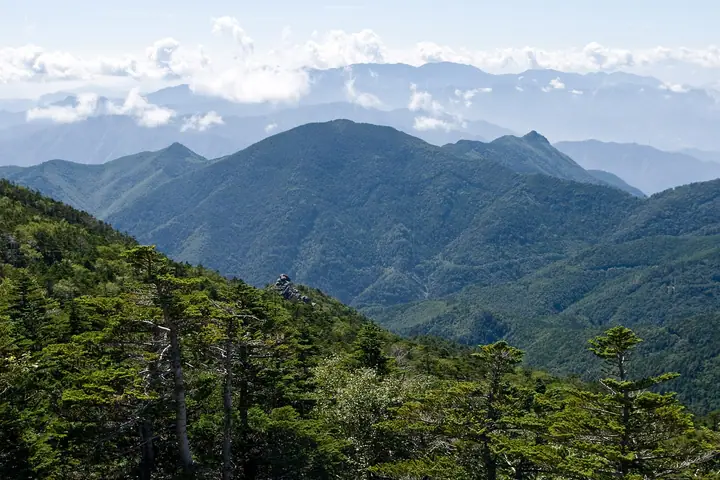
Mount Kurogane is a 2,232 m peak in Yamanashi City, Yamanashi, set south of the main ridge of the Okuchichibu massif within Chichibu-Tama-Kai National Park. Its pyramidal silhouette rises just north of Mount Kentoku, and the summit opens onto a sweeping view of the Okuchichibu peaks, Mount Fuji, and the Southern Alps. The classic routes climb from above the Nanatsu-gama Godan Falls in the Nishizawa Gorge or via Mount Kentoku; more recently, a forest road extending north from the Ōdaira Plateau toward Aosasa lets drivers reach a saddle and finish in about 1 hour 40 minutes. It is quieter and less visited than neighbouring Kentoku.
Mount Kurogane at a glance
- Weather: The most settled day in the next 7 days is Sun, November 8: clear, gusts up to 7 m/s. Sat, Nov 7: strong wind (gusts up to 16 m/s).
Mount Kurogane weather (hourly, 14 days)
Sunrise today 06:09, sunset 16:49
| Tue, 11/3 | Wed, 11/4 | Thu, 11/5 | Fri, 11/6 | Sat, 11/7 | Sun, 11/8 | Mon, 11/9 | Tue, 11/10 | Wed, 11/11 | Thu, 11/12 | Fri, 11/13 | Sat, 11/14 | Sun, 11/15 | Mon, 11/16 | Tue, 11/17 | |||||||||||||||||||||||||||||||||||||||||||||||||||||||||||||||||||||
|---|---|---|---|---|---|---|---|---|---|---|---|---|---|---|---|---|---|---|---|---|---|---|---|---|---|---|---|---|---|---|---|---|---|---|---|---|---|---|---|---|---|---|---|---|---|---|---|---|---|---|---|---|---|---|---|---|---|---|---|---|---|---|---|---|---|---|---|---|---|---|---|---|---|---|---|---|---|---|---|---|---|---|---|
| Japan time | 21 | 23 | 1 | 3 | 5 | 7 | 9 | 11 | 13 | 15 | 17 | 19 | 21 | 0 | 3 | 6 | 9 | 12 | 15 | 18 | 21 | 0 | 3 | 6 | 9 | 12 | 15 | 18 | 21 | 0 | 3 | 6 | 9 | 12 | 15 | 18 | 21 | 0 | 3 | 6 | 9 | 12 | 15 | 18 | 21 | 0 | 3 | 6 | 9 | 15 | 21 | 3 | 9 | 15 | 21 | 3 | 9 | 15 | 21 | 3 | 9 | 15 | 21 | 3 | 9 | 15 | 21 | 3 | 9 | 15 | 21 | 3 | 9 | 15 | 21 | 3 | 9 | 15 | 21 | 3 | 9 | 15 | |
  | | |   | |   | | | |   |   | | | | | |   |   |   |   |   |  | | |  | | | | | | | | | | | | | | | | | | |   | | | | | | | | |   |   | | |   | |   |  | | | | | | | | | | | | | | | | | | | | | | | ||
| Temperature | °C | -1° | -1° | 0° | 0° | 0° | 0° | 1° | 4° | 4° | 2° | 1° | 1° | 0° | 1° | 1° | 2° | 6° | 10° | 7° | 4° | 3° | 2° | 2° | 2° | 7° | 11° | 10° | 2° | -1° | -3° | -4° | -5° | 1° | 2° | 2° | -4° | -6° | -5° | -5° | -5° | 1° | 5° | 3° | -3° | -2° | -2° | -2° | -2° | 1° | 0° | -4° | -5° | -4° | 0° | -3° | -7° | -4° | -3° | -9° | -6° | 0° | 1° | -4° | -7° | 0° | 2° | -6° | -6° | 1° | 3° | -4° | -4° | 2° | 3° | 2° | 1° | 7° | 7° | -4° | -1° | 0° | 1° |
| Precipitation | mm | 0.6 | 0.4 | 0.3 | 0.3 | 0.6 | 1.0 | 2.9 | 8 | 10 | 6 | 0.8 | 0.5 | 0.1 | 0.9 | 2.6 | 6 | 2.2 | 0.2 | 0.3 | 11 | 13 | 0.2 | 0.1 | |||||||||||||||||||||||||||||||||||||||||||||||||||||||||||
| New snow | cm | – | – | 0.6 | 3.8 | 1.3 | <.1 | <.1 | |||||||||||||||||||||||||||||||||||||||||||||||||||||||||||||||||||||||||||
| Snow depth | cm | 0 | 0 | 0 | 0 | 0 | 0 | 0 | 0 | 0 | 0 | 0 | 0 | 0 | 0 | 0 | 0 | 0 | 0 | 0 | 0 | 0 | 0 | 0 | 0 | 0 | 0 | 0 | 0 | 0 | 0 | 0 | 0 | 0 | 0 | 0 | 0 | 0 | 0 | 0 | 0 | 0 | 0 | 0 | 0 | 0 | 0 | 0 | 0 | 0 | 0 | <1 | 4 | 4 | 2 | 2 | 2 | 2 | 2 | 2 | 2 | 1 | 1 | 1 | 1 | 1 | 1 | 1 | 1 | 1 | <1 | <1 | <1 | <1 | <1 | <1 | 0 | 0 | 0 | 0 | 0 | 0 | 0 |
| Wind | m/s | 0 | 0 | 1 | 0 | 0 | 0 | 0 | 1 | 2 | 1 | 1 | 1 | 1 | 1 | 1 | 1 | 1 | 1 | 1 | 1 | 1 | 1 | 1 | 1 | 2 | 3 | 2 | 1 | 1 | 1 | 1 | 2 | 3 | 4 | 2 | 0 | 1 | 1 | 1 | 1 | 1 | 2 | 0 | 0 | 2 | 1 | 1 | 1 | 1 | 1 | 2 | 1 | 0 | 2 | 2 | 2 | 6 | 4 | 1 | 1 | 2 | 2 | 0 | 1 | 2 | 1 | 1 | 1 | 1 | 1 | 2 | 1 | 3 | 2 | 3 | 3 | 2 | 3 | 2 | 2 | 2 | 2 |
| Wind gusts | m/s | 4 | 4 | 5 | 5 | 5 | 4 | 5 | 7 | 7 | 7 | 6 | 6 | 7 | 8 | 8 | 6 | 5 | 7 | 7 | 9 | 7 | 7 | 8 | 8 | 9 | 11 | 12 | 9 | 7 | 8 | 10 | 12 | 14 | 16 | 15 | 11 | 7 | 7 | 8 | 7 | 7 | 7 | 7 | 5 | 8 | 8 | 8 | 8 | 7 | 8 | 5 | 5 | 5 | 10 | 8 | 12 | 21 | 22 | 16 | 7 | 8 | 9 | 7 | 6 | 10 | 12 | 5 | 5 | 5 | 7 | 7 | 7 | 9 | 13 | 14 | 14 | 13 | 12 | 13 | 8 | 7 | 8 |
| Wind dir. | ↓ | ↓ | ↓ | ↓ | ↓ | ↓ | ↓ | ↓ | ↓ | ↓ | ↓ | ↓ | ↓ | ↓ | ↓ | ↓ | ↓ | ↓ | ↓ | ↓ | ↓ | ↓ | ↓ | ↓ | ↓ | ↓ | ↓ | ↓ | ↓ | ↓ | ↓ | ↓ | ↓ | ↓ | ↓ | ↓ | ↓ | ↓ | ↓ | ↓ | ↓ | ↓ | ↓ | ↓ | ↓ | ↓ | ↓ | ↓ | ↓ | ↓ | ↓ | ↓ | ↓ | ↓ | ↓ | ↓ | ↓ | ↓ | ↓ | ↓ | ↓ | ↓ | ↓ | ↓ | ↓ | ↓ | ↓ | ↓ | ↓ | ↓ | ↓ | ↓ | ↓ | ↓ | ↓ | ↓ | ↓ | ↓ | ↓ | ↓ | ↓ | ↓ | |
Huts, campsites and lodging near Mount Kurogane
Mountain huts
Campsites
- 7inchCAMP ミチノエキ・ミトミ DOGBASE
- 笛吹小屋キャンプ場
Lists that include Mount Kurogane
Mount Kurogane facts
- Also known as
- Kuroganeyama
- Elevation
- 2,232 m
- Location
- Yamanashi, Yamanashi
35.841299, 138.709812 - National Park
- 秩父多摩甲斐国立公園
- Website
- www.city.yamanashi.yamanashi.jp
- Trail Map
- www.pref.yamanashi.jp (PDF)
- Wikipedia
- ja.wikipedia.org